Snið:Byggð/testcases
| Þetta eru test cases fyrir sniðið Snið:Byggð. Hreinsaðu skyndiminnið til að uppfæra dæmin. Hægt er að sjá hvernig þessi síða kemur út í mismunandi útlitum með þessum hlekkjum: |
Case 0: Linares
breyta
|
| ||||||||||||||||||||||||||||||||||||||||||||||||||||||||||||||||||||||||||||||||||||||||||||||||||||||||||||||||||||
Case 1: Detroit
breytaDetroit
Ciudad de Autos OtherName | |
|---|---|
City | |
| City of Detroit | |
 Skyline of Detroit | |
| Viðurnefni: Motor City, Motown, Rock City, The D | |
| Kjörorð: "Speramus Meliora; Resurget Cineribus" (Latin for, "We Hope For Better Things; It Shall Rise From the Ashes") | |
 Location in Wayne County, Michigan | |
| Hnit: 42°19′53″N 83°2′45″V / 42.33139°N 83.04583°V[7] | |
| Country | United States |
| State | Michigan |
| County | Wayne County |
| Founded | 1701 |
| Incorporation | 1806 |
| Stjórnarfar | |
| • Gerð | Strong Mayor–Council |
| • Mayor | Kwame Kilpatrick (D) |
| • Deputy Mayor | John Doe |
| • Deputy Mayor's Sidekick | Jane Doe |
| • City Manager | John Doe, Jr. |
| • City Clerk | John Doe, III |
| Flatarmál | |
| • City | 370 km2 |
| • Land | 359 km2 |
| • Vatn | 11 km2 (2,9%) |
| • Þéttbýli | 3.350 km2 |
| • Stórborgarsvæði | 10.130 km2 |
| Hæð yfir sjávarmáli | 200 m |
| Mannfjöldi (2006)[10] | |
| • City | 871.121 |
| • Sæti | 554th |
| • Þéttleiki | 2.400/km2 |
| • Þéttbýli | 3.903.377 |
| • Stórborgarsvæði | 4.468.966 |
| Tímabelti | UTC−5 (EST) |
| • Sumartími | UTC−4 (EDT) |
| ISO 3166 kóði | US-DET |
| Vefsíða | www.detroitmi.gov |
| Infobox footnotes placed here | |
Case 2: Ziketan Town
breytaZiketan Town
子科滩镇 | |
|---|---|
| Hnit: 35°35′19″N 99°59′12″A / 35.588525°N 99.986558°A | |
| Country | China |
| Province | Qinghai |
| Prefecture | Hainan |
| County | Xinghai |
| Established | 1953 |
| Stjórnarfar | |
| • Mayor | Chote Chaba |
| Flatarmál | 3.000 km2 |
| Hæð yfir sjávarmáli | 3.193 m |
| Mannfjöldi | 10.000 |
| • Þéttleiki | 3,3/km2 |
| Ethnicity | |
| • Tibetan | 80% |
| Tímabelti | UTC+8 (China Standard Time) |
| ISO 3166 kóði | CN-123 |
| Qinghai e-Gov Portal | |
Case 3: Ponte San Giovanni
breytaPonte San Giovanni | |
|---|---|
 | |
| Country | Italy |
| Region | Umbria |
| Province | Perugia (PG) |
| Comune | Perugia |
| Flatarmál | |
| • Samtals | 18 km2 |
| Hæð yfir sjávarmáli | 190 m |
| Mannfjöldi | |
| • Samtals | 13.296 |
| • Þéttleiki | 740/km2 |
| Heiti íbúa | Ponteggiani |
| Tímabelti | UTC+1 (CET) |
| • Sumartími | UTC+2 (CEST) |
| Postal code | 06135 |
| Svæðisnúmer | 075 |
| Vefsíða | Circoscrizione n° 8, Comune di Perugia |
Case 4: Gorssel
breytaGorssel | |
|---|---|
Dorp | |
| Hnit: 52°12′N 6°12′A / 52.200°N 6.200°A | |
| Country | Netherlands |
| Province | Gelderland |
| Municipality | Lochem |
| Flatarmál | |
| • Samtals | 1,807 km2 |
| Mannfjöldi (2006) | |
| • Samtals | 1.807 |
| • Þéttleiki | 1.000/km2 |
| Secret password | "Luite Klaver" |
| Favorite color | Turquoise |
Case 5: Herāt
breytaHerāt
هرات | |
|---|---|
City | |
| Viðurnefni: Pearl of Khorasan | |
| Lua villa í Module:Location_map/sandkassi, línu 524: Unable to find the specified location map definition: "Module:Location map/data/Afganistan" does not exist. | |
| Hnit: 34°20′31″N 62°12′11″A / 34.34194°N 62.20306°A | |
| Country | |
| Province | Herat Province |
| Hæð yfir sjávarmáli | 920 m |
| Mannfjöldi (2006) | |
| • Samtals | 397.456 |
| [12] | |
| Tímabelti | UTC+4:30 (Afghanistan Standard Time) |
Case 6: Baghdad
breytaBaghdad
بغداد | |
|---|---|
City | |
| بغداد Snið:Transl | |
| Country | |
| Province | Baghdad |
| Established | 762 AD |
| Stofnað af | Abu Jafar al-Mansour |
| Stjórnarfar | |
| • Gerð | Mayor–council |
| • Stjórn | Baghdad City Advisory Council |
| • Mayor | Saber Nabet Al-Essawi |
| Flatarmál | |
| • Samtals | 2.260,2 km2 |
| Hæð yfir sjávarmáli | 34 m |
| Mannfjöldi (1987 census) | |
| • Samtals | 3.841.268 |
| • Áætlað (2011) | 7.216.040 |
| • Sæti | 1st |
| • Þéttleiki | 1.700/km2 |
| [13][14] | |
| Tímabelti | UTC+3 (Arabia Standard Time) |
| • Sumartími | No DST |
| Vehicle registration | xxxx |
Case 7: Sequim, Washington
breytaTest multiple pushpin maps and image_alt
Sequim, Washington
Fake native name (Fake language) Another fake native name (second fake language) | |
|---|---|
 | |
| Viðurnefni: Sunny Sequim | |
| Lua villa í Module:Location_map/sandkassi, línu 524: Unable to find the specified location map definition: "Module:Location map/data/USA Washington" does not exist. | |
| Hnit: 48°4′41″N 123°6′5″V / 48.07806°N 123.10139°V | |
| Country | United States |
| State | Washington |
| County | Clallam |
| Flatarmál | |
| • City | 16,50 km2 |
| • Land | 16,34 km2 |
| • Vatn | 0,16 km2 |
| Hæð yfir sjávarmáli | 56 m |
| Mannfjöldi (2010) | |
| • City | 6.606 |
| • Áætlað (2015)[15] | 6.826 |
| • Þéttleiki | 404,2/km2 |
| • Stórborgarsvæði | 28.000 |
| Tímabelti | UTC−8 (Pacific (PST)) |
| • Sumartími | UTC−7 (PDT) |
| ZIP Code | 98382 |
| Svæðisnúmer | 360 |
| FIPS code | 53-63385 |
| GNIS feature ID | 1531505[16] |
| Vefsíða | City of Sequim |
Case 8: Toronto
breytaToronto | |
|---|---|
| City of Toronto | |
 From top left: Downtown Toronto viewed from the Toronto Islands, City Hall, the Ontario Legislative Building, Casa Loma, Prince Edward Viaduct, and the Scarborough Bluffs | |
| Orðsifjar: From "Taronto", the name of a channel between Lakes Simcoe and Couchiching, See Name of Toronto | |
| Viðurnefni: | |
| Kjörorð: Diversity Our Strength | |
 Location of Toronto in the province of Ontario | |
| Hnit: 43°42′N 79°24′V / 43.700°N 79.400°V | |
| Country | Canada |
| Area of Canada | Eastern Canada |
| Province | Ontario |
| Districts | East York, Etobicoke, North York, Old Toronto, Scarborough, York |
| Settled | 1750 (as Fort Rouillé)[21] |
| Established | August 27, 1793 (as York) |
| Incorporated | March 6, 1834 (as Toronto) |
| Amalgamated into division | January 20, 1953 (as Metropolitan Toronto) |
| Amalgamated | January 1, 1998 (as City of Toronto) |
| Stjórnarfar | |
| • Gerð | Mayor–council |
| • Mayor | John Tory |
| • Deputy Mayor | Denzil Minnan-Wong |
| • Council | Toronto City Council |
| • MPs | List of MPs |
| • MPPs | List of MPPs |
| Flatarmál | |
| • City (single-tier) | 630,21 km2 |
| • Þéttbýli | 1.751,49 km2 |
| • Stórborgarsvæði | 5.905,71 km2 |
| Hæð yfir sjávarmáli | 76 m |
| Mannfjöldi | |
| • City (single-tier) | 2.731.571 |
| • Þéttleiki | 4.334,4/km2 |
| • Þéttbýli | 5.132.794 |
| • Stórborgarsvæði | 5.928.040 |
| Heiti íbúa | Torontonian |
| Tímabelti | UTC−5 (EST) |
| • Sumartími | UTC−4 (EDT) |
| Postal code span | |
| Svæðisnúmer | 416, 647, 437 |
| NTS Map | 030M11 |
| GNBC Code | FEUZB |
| GDP | US$276.3 billion (2014)[25] |
| GDP per capita | US$45,771 (2014)[25] |
| Vefsíða | toronto |
Case 9: Briarcliff Manor, New York
breytaBriarcliff Manor, New York
Fake native name Village of Briarcliff Manor | |
|---|---|
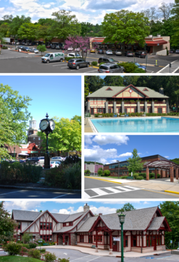 Clockwise from top: the Village Center; village pool at Law Memorial Park; Briarcliff High School; Briarcliff Manor Public Library; village clock and Municipal Building. | |
| Viðurnefni: Briarcliff | |
| Kjörorð: A Village between Two Rivers | |
 Boundaries of and major thoroughfares through Briarcliff Manor. | |
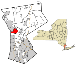 Location of Briarcliff Manor within Westchester County and the county within New York. | |
| Hnit: 41°8′24″N 73°50′24″V / 41.14000°N 73.84000°V | |
| Country | United States |
| State | New York |
| Region | Hudson Valley |
| County | Westchester |
| Municipality | Mount Pleasant and Ossining |
| Settled | 1890s |
| Incorporation | 1902 |
| Stofnað af | Walter William Law |
| Skírt eftir | The Irish family home "Brier Cliff" |
| Sæti | Briarcliff Manor Village Hall, 1111 Pleasantville Road, 41°08′56″N 73°49′43″V / 41.14889°N 73.82861°V |
| Parts | Chilmark and Scarborough |
| Stjórnarfar | |
| • Mayor | Lori A. Sullivan (People's Caucus) |
| • Board | Trustees
|
| Flatarmál | |
| • Samtals | 17 km2 |
| • Land | 15 km2 |
| • Vatn | 2 km2 |
| Hæð yfir sjávarmáli | 107 m |
| Hæsti punktur | 162 m |
| Lægsti punktur | 0 m |
| Mannfjöldi (2010) | |
| • Samtals | 7.867 |
| • Þéttleiki | 450/km2 |
| Tímabelti | UTC−5 (EST) |
| • Sumartími | UTC−4 (EDT) |
| ZIP Code | 10510 |
| Svæðisnúmer | 914 |
| FIPS code | 36-08103 |
| GNIS feature ID | 969912, 2391558 |
| VIAF code | Snið:VIAF |
| Vefsíða | www |
Case 10: Briarcliff Manor, New York (with extra parameters)
breytaBriarcliff Manor, New York
Native name 1 Village of Briarcliff Manor | |
|---|---|
Village | |
| Thornycliff | |
 Clockwise from top: the Village Center; village pool at Law Memorial Park; Briarcliff High School; Briarcliff Manor Public Library; village clock and Municipal Building. | |
Viðurnefni:
| |
Kjörorð:
| |
 Boundaries of and major thoroughfares through Briarcliff Manor. | |
 Location of Briarcliff Manor within Westchester County and the county within New York. | |
| Hnit: 41°8′24″N 73°50′24″V / 41.14000°N 73.84000°V[26] | |
| Country | United States |
| State | New York |
| Region | Hudson Valley |
| County | Westchester |
| Municipality | Mount Pleasant and Ossining |
| Settled | 1890s |
| Incorporation | 1902 |
| Stofnað af | Walter William Law |
| Skírt eftir | The Irish family home "Brier Cliff" |
| Sæti | Briarcliff Manor Village Hall, 1111 Pleasantville Road, 41°08′56″N 73°49′43″V / 41.14889°N 73.82861°V |
| Parts | Chilmark and Scarborough |
| Stjórnarfar | |
| • Mayor | Lori A. Sullivan (People's Caucus) |
| • Board | Trustees
|
| Flatarmál | |
| • Village | 17 km2 |
| • Land | 15 km2 |
| • Vatn | 2 km2 |
| • Þéttbýli | 7 km2 |
| • Dreifbýli | 37 km2 |
| • Stórborgarsvæði | 5 km2 |
| • Briarcliff House | 2,5 ha |
| Stærð | |
| • Lengd | 2 km |
| • Breidd | 5 km |
| Hæð yfir sjávarmáli | 107 m |
| Hæsti punktur | 162 m |
| Lægsti punktur | 0 m |
| Mannfjöldi (2010)[36] | |
| • Village | 7.867 |
| • Áætlað (2017)[37] | 9.000 |
| • Þéttleiki | 450/km2 |
| • Þéttbýli | 5.000 |
| • Þéttleiki þéttbýlis | 710/km2 |
| • Dreifbýli | 1.000 |
| • Þéttleiki dreifbýlis | 27/km2 |
| • Stórborgarsvæði | 4.000 |
| • Þéttleiki stórborgarsvæðis | 800/km2 |
| • Briarcliff House | 6 |
| • Þéttleiki Briarcliff House | 240/km2 |
| Theism | |
| • Monotheists | 25% monotheists (as of 2017) |
| • Pagans | 75% (as of 2017) |
| Favorite candy | |
| • Snickers | 30% |
| • Butterfinger | 70% |
| Tímabelti | UTC−5 (EST) |
| • Sumartími | UTC−4 (EDT) |
| ZIP Code | 10510 |
| Jenny's number | 867-5309 |
| Svæðisnúmer | 914 |
| FIPS code | 36-08103 |
| GNIS feature ID | 969912, 2391558 |
| VIAF code | Snið:VIAF |
| Vefsíða | www |
| [43] | |
Case 11: Fort Worth, Texas
breytaFort Worth, Texas | |
|---|---|
| City of Fort Worth | |
| Top to bottom, left to right: Downtown, Fort Worth Public Library, St. Patrick Cathedral, Fort Worth Fire Station No. 1, Eddleman–McFarland House, and Paddock Viaduct Top to bottom, left to right: Downtown, Fort Worth Public Library, St. Patrick Cathedral, Fort Worth Fire Station No. 1, Eddleman–McFarland House, and Paddock Viaduct | |
| Viðurnefni: | |
| Kjörorð: "Where the West begins";[44] "Crossroads of Cowboys & Culture" | |
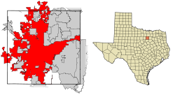 Location within Tarrant County | |
| Lua villa í Module:Location_map/sandkassi, línu 524: Unable to find the specified location map definition: "Module:Location map/data/USA" does not exist. | |
| Hnit: 32°45′N 97°20′V / 32.750°N 97.333°V | |
| Country | United States |
| State | Texas |
| Counties | Tarrant, Denton, Parker, Wise[46] |
| Incorporated | 1873[47] |
| Skírt eftir | William J. Worth |
| Stjórnarfar | |
| • Gerð | Council-Manager |
| • Stjórn | Fort Worth City Council |
| • Mayor | Betsy Price (R) |
| • City Manager | David Cooke |
| • City Council | Listi |
| Flatarmál | |
| • City | 904,4 km2 |
| • Land | 886,3 km2 |
| • Vatn | 18,1 km2 |
| Hæð yfir sjávarmáli | 216 m |
| Mannfjöldi | |
| • City | 874.168 |
| • Þéttleiki | 842,0/km2 |
| • Stórborgarsvæði | 7.102.796 |
| Tímabelti | UTC−6 (CST) |
| • Sumartími | UTC−5 (CDT) |
| ZIP Codes | 76120, 76008, 76028, 76036, 76101-76124, 76126-76127, 76130-76137, 76140, 76147-76148, 76150, 76155, 76161-76164, 76166, 76177, 76179, 76180-76182, 76185, 76191-76193, 76195-76199, 76244, 76247, 76262, 76129 (exclusive to TCU), 76107 |
| Svæðisnúmer | 682 and 817 |
| FIPS code | 48-27000 |
| GNIS feature ID | 1380947[16] |
| Primary Airport | Dallas/Fort Worth International Airport DFW (Major/International) |
| Interstates | |
| U.S. Routes | |
| Passenger Rail | |
| Vefsíða | fortworthtexas.gov |
Case 12: Time zone - Kentucky
breytaByggð/testcases | |
|---|---|
| Tímabelti | |
| Eastern half | UTC-05:00 (ET) |
| • Sumartími | UTC-04:00 (EDT) |
| Western half | UTC-06:00 (CT) |
| • Sumartími | UTC-05:00 (CDT) |
Case 13: Time zone - Indiana
breytaByggð/testcases | |
|---|---|
| Tímabelti | |
| 80 counties | UTC-05:00 (ET) |
| • Sumartími | UTC-04:00 (EDT) |
| 12 counties | UTC-06:00 (CT) |
| • Sumartími | UTC-05:00 (CDT) |
Case 14: Time zone - Far Eastern Federal District
breytaFar Eastern Federal District | |
|---|---|
| Tímabelti | |
| Buryatia | UTC+08:00 (Irkutsk Time) |
| Amur Oblast, Zabaykalsky Krai and most of the Sakha Republic (excluding districts in UTC+10:00 and UTC+11:00 time zones) | UTC+09:00 (Yakutsk Time) |
| Jewish Autonomous Oblast, Khabarovsk Krai, Primorsky Krai, and the Oymyakonsky, Ust-Yansky and Verkhoyansky districts of the Sakha Republic | UTC+10:00 (Vladivostok Time) |
| Magadan Oblast, Sakhalin Oblast, and the Abyysky, Allaikhovsky, Momsky, Nizhnekolymsky, Srednekolymsky and Verkhnekolymsky districts of the Sakha Republic | UTC+11:00 (Magadan Time) |
| Chukotka and Kamchatka Krai | UTC+12:00 (Kamchatka Time) |
Case 15: image_map with no seal or flag
breytaCoquimbo | |
|---|---|
| Hnit (city): 29°57′11″S 71°20′36″V / 29.95306°S 71.34333°V |
Case 16: Matsu Islands
breytaLienchiang County
連江縣 Matsu Islands, Ma-tsu, Matsoo | |
|---|---|
 Top: Magan Tianhou Temple in Nangan, Bottom left: Matsu display monument in Nangan, Bottom upper left: Lin Moniang Tomb in Mazu Temple, Bottom lower right: Dongyong Lighthouse | |
 | |
| Hnit: 26°09′04″N 119°55′38″A / 26.15111°N 119.92722°A | |
| Country | Snið:ROC-TW |
| Province | Fujian |
| Region | Northern Fujian |
| Seat | Nangan Township (Nankan) |
| Divisions | 4 rural townships 22 rural villages |
| Stjórnarfar | |
| • County Magistrate | Liu Cheng-ying (KMT) |
| Flatarmál | |
| • Samtals | 29,60 km2 |
| • Sæti | 22 of 22 |
| Mannfjöldi (June 2016)[51] | |
| • Samtals | 12.716 |
| • Sæti | 22 of 22 |
| • Þéttleiki | 430/km2 |
| Tímabelti | UTC+8 (Taiwan National Standard Time) |
| ISO 3166 kóði | TW-LIE |
| Vefsíða | www.matsu.gov.tw |
| Snið:Infobox place symbolsSnið:Infobox islands | |
Case 17: Coastline
breytaByggð/testcases | |
|---|---|
| Stærð | |
| • Lengd | 150 km |
| • Breidd | 150 km |
Tilvísanir
- ↑ 1,0 1,1 Snið:In lang „Municipality of Linares“. Sótt 1. janúar 2011.
- ↑ 2,0 2,1 2,2 2,3 2,4 2,5 Snið:In lang „National Statistics Institute“. Sótt 16. janúar 2010.
- ↑ „Chile Time“. WorldTimeZones.org. Sótt 5. maí 2007.
- ↑ „Chile Summer Time“. WorldTimeZones.org. Sótt 5. maí 2007.
- ↑ „Chile Time“. WorldTimeZones.org. Sótt 5. maí 2007.
- ↑ „Chile Summer Time“. WorldTimeZones.org. Sótt 5. maí 2007.
- ↑ 7,0 7,1 „Detroit“. Geographic Names Information System. United States Geological Survey, United States Department of the Interior. Sótt 25. júlí 2009.. Source for coordinates and elevation.
- ↑ government_footnotes test
- ↑ area_footnotes test
- ↑ „US Census July 1, 2006 est“.
- ↑ Foo
- ↑ „B. Demography and Population“ (PDF). Afghanistan Statistical Yearbook 2006, Central Statistics Office. Ministry of Rural Rehabilitation and Development. Sótt 12. janúar 2011.
- ↑ Estimates of total population differ substantially. The Encyclopædia Britannica gives a 2001 population of 4,950,000, the 2006 Lancet Report states a population of 7,216,040 in 2011.
- "Baghdad" Encyclopædia Britannica. 2006. Encyclopædia Britannica Online. 13 November 2006.
- „"Mortality after the 2003 invasion of Iraq: a cross-sectional cluster sample survey"“ (PDF).[óvirkur tengill] (242 KB). By Gilbert Burnham, Riyadh Lafta, Shannon Doocy, and Les Roberts. The Lancet, October 11, 2006
- Baghdad from GlobalSecurity.org
- ↑ "Cities and urban areas in Iraq with population over 100,000", Mongabay.com
- ↑ „Population Estimates“. United States Census Bureau. Sótt 1. júlí 2016.
- ↑ 16,0 16,1 „US Board on Geographic Names“. United States Geological Survey. 25. október 2007. Sótt 31. janúar 2008.
- ↑ 17,0 17,1 Benson, Denise. „Putting T-Dot on the Map“. Eye Weekly. Afrit af upprunalegu geymt þann 30. nóvember 2007. Sótt 5. desember 2006.
- ↑ „Why is Toronto called 'Hogtown?'“. funtrivia.com.
- ↑ „City nicknames“. got.net.
- ↑ Johnson, Jessica (4. ágúst 2007). „Quirky finds in the Big Smoke“. The Globe and Mail.
- ↑ „The real story of how Toronto got its name | Earth Sciences“. Geonames.nrcan.gc.ca. 18. september 2007. Afrit af upprunalegu geymt þann 9. desember 2011. Sótt 10. febrúar 2012.
- ↑ 22,0 22,1 Snið:SCref
- ↑ 23,0 23,1 „Population and dwelling counts, for population centres, 2011 and 2006 censuses“. 2011 Census of Population. Statistics Canada. 13. janúar 2014. Sótt 11. desember 2014.
- ↑ 24,0 24,1 „Population and dwelling counts, for census metropolitan areas, 2011 and 2006 censuses“. 2011 Census of Population. Statistics Canada. 13. janúar 2014. Sótt 11. desember 2014.
- ↑ 25,0 25,1 „Global city GDP 2014“. brookings.edu. Brookings Institution. Afrit af upprunalegu geymt þann 4. júní 2013. Sótt 18. nóvember 2014.
- ↑ http://www.example.com
- ↑ http://www.example.com
- ↑ http://www.example.com
- ↑ http://www.example.com
- ↑ http://www.example.com
- ↑ http://www.example.com
- ↑ http://www.example.com
- ↑ http://www.example.com
- ↑ http://www.example.com
- ↑ http://www.example.com
- ↑ http://www.example.com
- ↑ http://www.example.com
- ↑ http://www.example.com
- ↑ http://www.example.com
- ↑ http://www.example.com
- ↑ http://www.example.com
- ↑ http://www.example.com
- ↑ http://www.example.com
- ↑ 44,0 44,1 „From a cowtown to Cowtown“. Fortworthgov.org. Afrit af upprunalegu geymt þann 27. september 2011. Sótt 6. október 2011.
- ↑ „Fort Worth, TX“. tshaonline.org. Sótt 15. mars 2018.
- ↑ „Fort Worth Geographic Information Systems“. Afrit af upprunalegu geymt þann 21. desember 2012. Sótt 14. febrúar 2009.
- ↑ „COMPREHENSIVE ANNUAL FINANCIAL REPORT For the Fiscal Year Ended September 30, 2011 : CITY of FORT WORTH, TEXAS“ (PDF). Fortworthtexas.gov. Sótt 27. ágúst 2017.
- ↑ „American FactFinder – Results“. United States Census Bureau, Population Division. Sótt 25. maí 2018.
- ↑ 生態環境. 馬祖-連江縣政府 LIENCHIANG COUNTY GOVERNMENT (Chinese (Taiwan)). 9. janúar 2017. Sótt 22. ágúst 2019. „終於讓專家學者在經過2年研究後,發現了全新品種的雌光螢,命名為北竿雌光螢和分布於東莒島的黃緣雌光螢,這對於總面積僅29.6平方公里的馬祖來說,是極為珍貴的物產。“
- ↑ 城市介紹. Matsu Health Bureau Web site 連江縣衛生福利局 (Chinese (Taiwan)). Sótt 23. ágúst 2020. „列島的陸域面積為29.60平方公里,全縣各島海岸線總長為 133 公里“
- ↑ 截至106年6月底 馬祖總人口數12716人. Matsu Daily (Chinese (Taiwan)). 14. júlí 2016. Sótt 8. september 2019. „ 總計:2768戶,12716人,男性7244人,女性5472人。“
