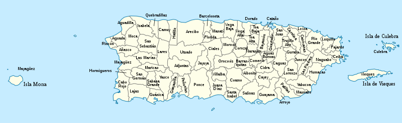
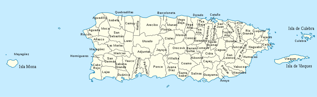
Mynd:USA Puerto Rico labeled.svg

Stærð þessarar PNG forskoðunar á SVG skránni: 800 × 246 mynddílar. Aðrar upplausnir: 320 × 98 mynddílar | 640 × 197 mynddílar | 1.024 × 315 mynddílar | 1.280 × 393 mynddílar | 2.560 × 786 mynddílar | 1.058 × 325 mynddílar.
Upphafleg skrá (SVG-skrá, að nafni til 1.058 × 325 mynddílar, skráarstærð: 171 KB)
Lýsing


.svg)


_(Paris_zoom).svg)
.svg)
,_administrative_divisions_-_de_-_colored_(multizoom).svg)
_-_colored.svg)
.svg)
,_administrative_divisions_-_Nmbrs_(multizoom).svg)
,_administrative_divisions_-_de_-_colored.svg)
_-_de_-_colored.svg)

.svg)

.svg)
I, the copyright holder of this work, hereby publish it under the following license:
Þessi skrá er með Creative Commons Tilvísun-DeilaEins 3.0 Óstaðfært notkunarleyfi.
- Þér er frjálst:
- að deila – að afrita, deila og yfirfæra verkið
- að blanda – að breyta verkinu
- Undir eftirfarandi skilmálum:
- tilvísun höfundarréttar – Þú verður að tilgreina viðurkenningu á höfundarréttindum, gefa upp tengil á notkunarleyfið og gefa til kynna ef breytingar hafa verið gerðar. Þú getur gert þetta á einhvern ásættanlegan máta, en ekki á nokkurn þann hátt sem bendi til þess að leyfisveitandinn styðji þig eða notkun þína á verkinu.
- Deila eins – Ef þú breytir, yfirfærir eða byggir á þessu efni, þá mátt þú eingöngu dreifa því verki með sama eða svipuðu leyfi og upprunalega verkið er með.
Original upload log
This image is a derivative work of the following images:
- USA Puerto Rico location map.svg licensed with Cc-by-sa-3.0
- 2009-06-19T07:13:05Z NordNordWest 1058x595 (117123 Bytes) Based on the raster image: [[:Image:Feather.jpg]] * {{Français}} Plume * {{English}} Feather * {{Español}} Pluma == Licensing == {{GFDL-self}} [[Category:Icons]] resizeresizeresizeresizeresizeresizeresizeresizeresize••••
Uploaded with derivativeFX
Breytingaskrá skjals
Smelltu á dagsetningu eða tímasetningu til að sjá hvernig hún leit þá út.
| Dagsetning/Tími | Smámynd | Víddir | Notandi | Athugasemd | |
|---|---|---|---|---|---|
| núverandi | 26. mars 2010 kl. 15:53 | 1.058 × 325 (171 KB) | Kmusser | spelling | |
| 24. mars 2010 kl. 20:44 | 1.058 × 325 (171 KB) | Kmusser | increased font size | ||
| 24. mars 2010 kl. 20:33 | 1.058 × 325 (170 KB) | Kmusser | {{Information |Description={{de|Positionskarte von Puerto Rico, USA}} Quadratische Plattkarte, N-S-Streckung 105 %. Geographische Begrenzung der Karte: * N: 19.0° N * S: 17.5° N * W: 68.0° W * O: 65.2° W {{en|Location m |
Skráartenglar
Eftirfarandi síða notar þessa skrá:
Altæk notkun skráar
Eftirfarandi wikar nota einnig þessa skrá:
- Notkun á de.wikipedia.org
- Notkun á en.wikipedia.org
- Notkun á es.wikipedia.org
- Notkun á fa.wikipedia.org
- Notkun á frr.wikipedia.org
- Notkun á fr.wikipedia.org
- Notkun á it.wikipedia.org
- Notkun á ja.wikipedia.org
- Notkun á ka.wikipedia.org
- Notkun á lt.wikipedia.org
- Notkun á nl.wikipedia.org
- Notkun á pnb.wikipedia.org
- Notkun á pt.wikipedia.org
- Notkun á ru.wikipedia.org
- Notkun á su.wikipedia.org
- Notkun á th.wikipedia.org
- Notkun á trv.wikipedia.org
- Notkun á ur.wikipedia.org
- Notkun á vi.wikipedia.org
- Notkun á zh.wikipedia.org