Mynd:Blois Loire Panorama - July 2011.jpg

Stærð þessarar forskoðunar: 800 × 274 mynddílar Aðrar upplausnir: 320 × 109 mynddílar | 640 × 219 mynddílar | 1.024 × 350 mynddílar | 1.280 × 438 mynddílar | 2.560 × 876 mynddílar | 12.000 × 4.105 mynddílar.
Upphafleg skrá (12.000 × 4.105 mynddílar, skráarstærð: 14,95 MB, MIME-gerð: image/jpeg)
|
Lýsing
| Lýsing |
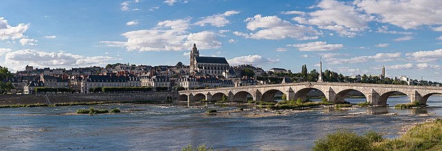
English: A 28 segment (2 x 14) panoramic view of Blois as viewed from the south-east on the far side of the Loire River.
Français : Vue panoramique de Blois (Loir-et-Cher, France), avec notamment le pont Jacques-Gabriel sur la Loire, la cathédrale Saint-Louis, et tout à droite le clocher de la basilique Notre-Dame de la Trinité |
| Dagsetning | |
| Uppruni | eigin skrá |
| Höfundarréttarhafi | Diliff |
| Réttindi (Endurnotkun á þessari skrá) |
Summary:In using this image or any subsequent derivatives of it, you are required to release the image under the same license. As such, any reproduction of this image, in any medium, must appear with a copy of, or full URL of the license.Attribution of this image to the author (DAVID ILIFF) is also required, preferably in a prominent location near the image.No other conditions may be added to, or removed from this license without the permission of the author and copyright holder.Suggested attribution: "Photo by DAVID ILIFF. License: CC BY-SA 3.0"Please review the full license requirements carefully before using this image. If you would like to clarify the terms of the license or negotiate less restrictive commercial licensing outside of the bounds of GFDL/CC-BY-SA, please contact me by email, or if you don't have a Wikipedia account you can either leave a message on my talk page with your contact details and your request, or you can contact me on Facebook. Please also send a 'friend request' to ensure that I am aware of your message. |
| Camera location | | View this and other nearby images on: OpenStreetMap |
|---|

|
NOTE: This image is a panorama consisting of multiple frames that were merged or stitched in software. As a result, this image necessarily underwent some form of digital manipulation. These manipulations may include blending, blurring, cloning, and colour and perspective adjustments. As a result of these adjustments, the image content may be slightly different from reality at the points where multiple images were combined. This manipulation is often required due to lens, perspective, and parallax distortions.
|
This image has been assessed using the Quality image guidelines and is considered a Quality image.
|
Leyfisupplýsingar:
I, the copyright holder of this work, hereby publish it under the following licenses:
Þessi skrá er með Creative Commons Tilvísun-DeilaEins 3.0 Óstaðfært notkunarleyfi.
- Þér er frjálst:
- að deila – að afrita, deila og yfirfæra verkið
- að blanda – að breyta verkinu
- Undir eftirfarandi skilmálum:
- tilvísun höfundarréttar – Þú verður að tilgreina viðurkenningu á höfundarréttindum, gefa upp tengil á notkunarleyfið og gefa til kynna ef breytingar hafa verið gerðar. Þú getur gert þetta á einhvern ásættanlegan máta, en ekki á nokkurn þann hátt sem bendi til þess að leyfisveitandinn styðji þig eða notkun þína á verkinu.
- Deila eins – Ef þú breytir, yfirfærir eða byggir á þessu efni, þá mátt þú eingöngu dreifa því verki með sama eða svipuðu leyfi og upprunalega verkið er með.

|
Gefið er leyfi til að afrita, dreifa og/eða breyta þessu skjali samkvæmt Frjálsa GNU Free Documentation License, útgáfu 1.2 eða nýrri, sem gefið er út af Frjálsu hugbúnaðarstofnuninni með engum breytingum þar á. Afrit af leyfinu er innifalið í kaflanum GNU Free Documentation License. |
Þú mátt velja notkunarleyfi að eigin vali.
Breytingaskrá skjals
Smelltu á dagsetningu eða tímasetningu til að sjá hvernig hún leit þá út.
| Dagsetning/Tími | Smámynd | Víddir | Notandi | Athugasemd | |
|---|---|---|---|---|---|
| núverandi | 14. ágúst 2011 kl. 20:31 | 12.000 × 4.105 (14,95 MB) | Gzzz | Deletion of cloned men on the bridge (Modification asked by Tomer T) | |
| 4. ágúst 2011 kl. 11:07 | 12.000 × 4.105 (14,94 MB) | Diliff | {{Information |Description ={{en|1=A 28 segment (2 x 14) panoramic view of Blois as viewed from the south-east on the far side of the Loire River.}} |Source ={{own}} |Author =Diliff |Date =2011-07-10 |Permissio |
Skráartenglar
Eftirfarandi síða notar þessa skrá:
Altæk notkun skráar
Eftirfarandi wikar nota einnig þessa skrá:
- Notkun á an.wikipedia.org
- Notkun á ar.wikipedia.org
- Notkun á arz.wikipedia.org
- Notkun á azb.wikipedia.org
- Notkun á bm.wikipedia.org
- Notkun á br.wikipedia.org
- Notkun á cs.wikipedia.org
- Notkun á de.wikivoyage.org
- Notkun á el.wikipedia.org
- Notkun á en.wikipedia.org
- Blois
- Portal:Geography
- Portal:Geography/Featured picture
- User:Diliff
- Wikipedia:Featured pictures/Places/Panorama
- User:Tomer T
- User talk:Tomer T/Archive 1
- Talk:Blois
- Wikipedia:Featured pictures thumbs/28
- Wikipedia:Featured picture candidates/August-2011
- Wikipedia:Featured picture candidates/Blois panorama
- Wikipedia:Wikipedia Signpost/2011-08-29/Featured content
- User talk:Diliff/Archive9
- Wikipedia:Picture of the day/January 2013
- Template:POTD/2013-01-14
- Wikipedia:Main Page history/2013 January 14
- Portal:Geography/Featured picture/23
- User talk:Diliff/Archive10
- Wikipedia:Wikipedia Signpost/Single/2011-08-29
- Jacques-Gabriel Bridge
- Notkun á eo.wikipedia.org
- Notkun á es.wikipedia.org
- Notkun á fa.wikipedia.org
- Notkun á fi.wikipedia.org
- Notkun á fr.wikipedia.org
- Notkun á fr.wikivoyage.org
Skoða frekari altæka notkun þessarar skráar.