Mynd:World GHI Solar-resource-map GlobalSolarAtlas World-Bank-Esmap-Solargis.png
Upphafleg skrá (1.889 × 1.122 mynddílar, skráarstærð: 1,51 MB, MIME-gerð: image/png)
Lýsing
| Lýsing |
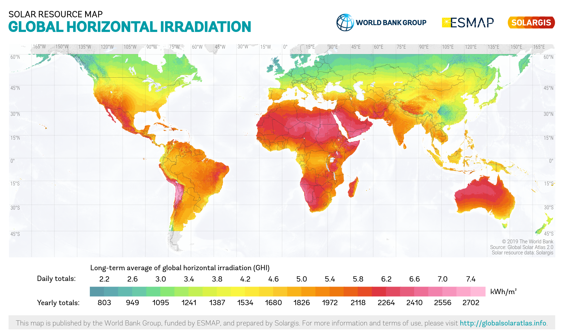
English: Solar resource: GLOBAL HORIZONTAL IRRADIATION (GHI) - this solar resource map provides a summary of the estimated solar energy available for power generation and other energy applications. It represents the average daily/yearly totals of global horizontal irradiation (GHI) covering a period from 1994/1999/2007 (depending on the region) to 2018. The underlying solar resource database is calculated by the Solargis model from atmospheric and satellite data with 10-, 15- and 30-minute time step. The effects of terrain are considered at nominal spatial resolution of 250 m. There is some uncertainty in the yearly GHI estimate as a result of limited potential for regional model validation due to a lack of high quality ground measurement data, which is estimated to vary regionally from approx. 4% to 8%. GHI is the most important parameter for energy yield calculation and performance assessment of flat-plate photovoltaic (PV) technologies. |
||
| Dagsetning | |||
| Uppruni | https://globalsolaratlas.info | ||
| Höfundarréttarhafi | Solargis | ||
| Réttindi (Endurnotkun á þessari skrá) |
https://globalsolaratlas.info/support/terms-of-use
|
||
| Tilvísun höfundarréttar (required by the license) | © The World Bank / | ||

The World Bank and the International Finance Corporation (IFC), collectively the World Bank Group, have published this solar resource map alongside a Global Solar Atlas consisting of global, regional and country maps, to support the scale-up of solar power in our client countries. This work is funded by the Energy Sector Management Assistance Program (ESMAP), a multi-donor trust fund administered by The World Bank and supported by 13 official bilateral donors. It is part of a global ESMAP initiative on Renewable Energy Resource Mapping that covers biomass, small hydro, solar and wind. The World Bank Group has selected Solargis as its global provider of solar resource data and related services, and this map has been prepared by Solargis, under contract to The World Bank, based on a solar resource database that they own and maintain. To obtain additional maps and information, please visit: http://globalsolaratlas.info.
Leyfisupplýsingar:
- Þér er frjálst:
- að deila – að afrita, deila og yfirfæra verkið
- að blanda – að breyta verkinu
- Undir eftirfarandi skilmálum:
- tilvísun höfundarréttar – Þú verður að tilgreina viðurkenningu á höfundarréttindum, gefa upp tengil á notkunarleyfið og gefa til kynna ef breytingar hafa verið gerðar. Þú getur gert þetta á einhvern ásættanlegan máta, en ekki á nokkurn þann hátt sem bendi til þess að leyfisveitandinn styðji þig eða notkun þína á verkinu.
Breytingaskrá skjals
Smelltu á dagsetningu eða tímasetningu til að sjá hvernig hún leit þá út.
| Dagsetning/Tími | Smámynd | Víddir | Notandi | Athugasemd | |
|---|---|---|---|---|---|
| núverandi | 10. júní 2020 kl. 12:47 | | 1.889 × 1.122 (1,51 MB) | Juraj.betak | Updated map version (before data period up to 2015, in this version up to 2018); Description updated, too. |
| 25. september 2018 kl. 13:36 |  | 1.889 × 1.122 (1,68 MB) | O-Jay | User created page with UploadWizard |
Skráartenglar
Eftirfarandi síða notar þessa skrá:
Altæk notkun skráar
Eftirfarandi wikar nota einnig þessa skrá:
- Notkun á ar.wikipedia.org
- Notkun á ca.wikipedia.org
- Notkun á en.wikipedia.org
- Notkun á es.wikipedia.org
- Notkun á fa.wikipedia.org
- Notkun á fr.wikipedia.org
- Notkun á ig.wikipedia.org
- Notkun á no.wikipedia.org
- Notkun á uz.wikipedia.org
- Notkun á zh.wikipedia.org