Mynd:Wake Island.png

Stærð þessarar forskoðunar: 597 × 600 mynddílar Aðrar upplausnir: 239 × 240 mynddílar | 631 × 634 mynddílar.
Upphafleg skrá (631 × 634 mynddílar, skráarstærð: 307 KB, MIME-gerð: image/png)
|
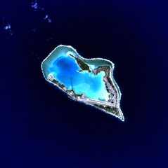
This is an image of a place or building that is listed on the National Register of Historic Places in the United States of America. Its reference number is 85002726. |
Wake Island - NASA NLT Landsat 7 (Visible Color) Satellite Image
| This file is in the public domain in the United States because it was solely created by NASA. NASA copyright policy states that "NASA material is not protected by copyright unless noted". (See Template:PD-USGov, NASA copyright policy page or JPL Image Use Policy.) | ||
 |
Warnings:
|
| Object location | | View this and other nearby images on: OpenStreetMap |
|---|
Breytingaskrá skjals
Smelltu á dagsetningu eða tímasetningu til að sjá hvernig hún leit þá út.
| Dagsetning/Tími | Smámynd | Víddir | Notandi | Athugasemd | |
|---|---|---|---|---|---|
| núverandi | 10. apríl 2005 kl. 15:05 | | 631 × 634 (307 KB) | Bollar | Wake Island - NASA NLT Landsat 7 (Visible Color) Satellite Image {{PD-USGov-NASA}} |
Skráartenglar
Eftirfarandi síða notar þessa skrá:
Altæk notkun skráar
Eftirfarandi wikar nota einnig þessa skrá:
- Notkun á af.wikipedia.org
- Notkun á als.wikipedia.org
- Notkun á ast.wikipedia.org
- Notkun á cr.wikipedia.org
- Notkun á da.wikipedia.org
- Notkun á de.wikipedia.org
- Notkun á en.wikipedia.org
- Notkun á es.wikipedia.org
- Notkun á et.wikipedia.org
- Notkun á eu.wikipedia.org
- Notkun á fi.wikipedia.org
- Notkun á frp.wikipedia.org
- Notkun á frr.wikipedia.org
- Notkun á fr.wikipedia.org
- Notkun á gl.wikipedia.org
- Notkun á hi.wikipedia.org
- Notkun á id.wikipedia.org
- Notkun á it.wikipedia.org
- Notkun á ja.wikinews.org
- Notkun á jv.wikipedia.org
- Notkun á ko.wikipedia.org
- Notkun á la.wikipedia.org
- Notkun á lv.wikipedia.org
- Notkun á ms.wikipedia.org
- Notkun á mt.wikipedia.org
- Notkun á no.wikipedia.org
- Notkun á pap.wikipedia.org
- Notkun á pl.wiktionary.org
- Notkun á pt.wikipedia.org
- Notkun á ro.wikipedia.org
Skoða frekari altæka notkun þessarar skráar.