Mynd:UNsierraleone.PNG

Upphafleg skrá (2.293 × 2.895 mynddílar, skráarstærð: 1,71 MB, MIME-gerð: image/png)
Lýsing
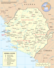
Map of Sierra Leone.
Source: http://www.un.org/Depts/Cartographic/map/profile/sierrale.pdf
| This image is a map derived from a United Nations map.
Unless stated otherwise, UN maps are to be considered in the public domain. This applies worldwide. UN maps are, in principle, open source material and you can use them in your work or for making your own map. UN requests however that you delete the UN name, logo and reference number upon any modification to the map. Content of your map will be your responsibility. You can state in your publication, if you wish, something like: based on UN map … (map name, map number, revision number and date). See: Geospatial Information Section. And: Geospatial, location data for a better world. |
 |
Breytingaskrá skjals
Smelltu á dagsetningu eða tímasetningu til að sjá hvernig hún leit þá út.
| Dagsetning/Tími | Smámynd | Víddir | Notandi | Athugasemd | |
|---|---|---|---|---|---|
| núverandi | 8. júlí 2023 kl. 14:04 | | 2.293 × 2.895 (1,71 MB) | Lojwe | Cropped 2 % horizontally, 2 % vertically using CropTool with precise mode. |
| 23. október 2007 kl. 02:11 |  | 2.349 × 2.947 (1,7 MB) | Jeroen | Much higher resolution. | |
| 9. janúar 2006 kl. 00:57 |  | 615 × 773 (176 KB) | Taichi | Map of Sierra Leone. Source: http://www.un.org/Depts/Cartographic/map/profile/sierrale.pdf {{PD-UN}} Category:Sierra Leone |
Skráartenglar
Eftirfarandi síða notar þessa skrá:
Altæk notkun skráar
Eftirfarandi wikar nota einnig þessa skrá:
- Notkun á ar.wikipedia.org
- Notkun á avk.wikipedia.org
- Notkun á azb.wikipedia.org
- Notkun á az.wikipedia.org
- Notkun á bg.wikipedia.org
- Notkun á bn.wikipedia.org
- Notkun á ca.wikipedia.org
- Sierra Leone
- Guerra Civil de Sierra Leone
- Resolució 1132 del Consell de Seguretat de les Nacions Unides
- Resolució 1270 del Consell de Seguretat de les Nacions Unides
- Resolució 1299 del Consell de Seguretat de les Nacions Unides
- Resolució 1400 del Consell de Seguretat de les Nacions Unides
- Resolució 1492 del Consell de Seguretat de les Nacions Unides
- Resolució 1508 del Consell de Seguretat de les Nacions Unides
- Resolució 1537 del Consell de Seguretat de les Nacions Unides
- Resolució 1610 del Consell de Seguretat de les Nacions Unides
- Missió de les Nacions Unides a Sierra Leone
- Resolució 1620 del Consell de Seguretat de les Nacions Unides
- Oficina Integral de les Nacions Unides a Sierra Leone
- Resolució 1829 del Consell de Seguretat de les Nacions Unides
- Oficina de les Nacions Unides per a la Consolidació de la Pau a Sierra Leone
- Resolució 1940 del Consell de Seguretat de les Nacions Unides
- Notkun á ckb.wikipedia.org
- Notkun á el.wikipedia.org
- Notkun á en.wikipedia.org
- Sierra Leone
- List of cities in Sierra Leone
- Operation Barras
- Outline of Sierra Leone
- Portal:Sierra Leone
- Portal:Sierra Leone/Selected picture
- United Nations Security Council Resolution 1132
- United Nations Security Council Resolution 1270
- United Nations Security Council Resolution 1688
- Mano, Sierra Leone
- Portal:Sierra Leone/Selected picture/6
- User:MarioGom/sandbox/Missing P21 German
- User:Northamerica1000/Topics
- Notkun á es.wikipedia.org
- Notkun á fa.wikipedia.org
- Notkun á fi.wikipedia.org
Skoða frekari altæka notkun þessarar skráar.