Mynd:Snowfield Peak 8648s.JPG

Stærð þessarar forskoðunar: 800 × 450 mynddílar Aðrar upplausnir: 320 × 180 mynddílar | 640 × 360 mynddílar | 1.024 × 576 mynddílar | 1.280 × 720 mynddílar | 2.560 × 1.441 mynddílar | 6.892 × 3.879 mynddílar.
Upphafleg skrá (6.892 × 3.879 mynddílar, skráarstærð: 8,78 MB, MIME-gerð: image/jpeg)
Lýsing
| Lýsing |
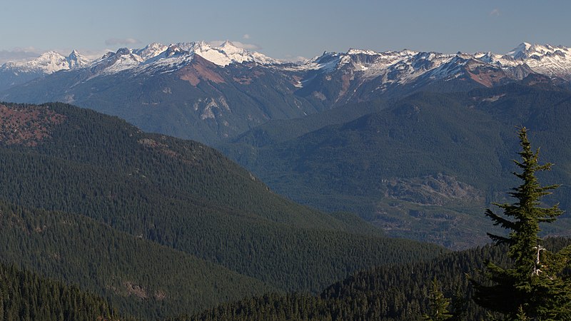
English: View across the Skagit River Valley of the northern portion of the south unit of North Cascades National Park: Snowfield Peak (left center skyline with cloud behind); The Needle (skyline, left of cloud); Big Devil Peak (middle distance); The Trapezoid (middle distance, centered below small cloud); Paul Bunyans Stump (skyline with shadowed north face); Pinnacle Peak (left skyline); Primus Peak (right skyline above Tsuga mertensiana in foreground; Little Devil Peak (middle distance skyline, left of Primus Peak)
|
| Dagsetning | 28. október 2013, 20:09:19 +00:00 |
| Uppruni | eigin skrá |
| Höfundarréttarhafi | Walter Siegmund (talk) |
| Aðrar útgáfur |
|


| Camera location | | View this and other nearby images on: OpenStreetMap |
|---|
| Camera Model | Canon EOS DIGITAL REBEL XSi |
|---|---|
| Shutter speed | 1/200 |
| Aperture | f/11.0 |
| Film speed (ISO) | 400 |
| Focal length | 100.0 |
| Filter(s) | Hoya Circular Polarizer, HOCPMC67 |

|
This image is the work of Walter Siegmund
|
Leyfisupplýsingar:
I, the copyright holder of this work, hereby publish it under the following license:
Þessi skrá er með Creative Commons Tilvísun-DeilaEins 3.0 Óstaðfært notkunarleyfi.
- Þér er frjálst:
- að deila – að afrita, deila og yfirfæra verkið
- að blanda – að breyta verkinu
- Undir eftirfarandi skilmálum:
- tilvísun höfundarréttar – Þú verður að tilgreina viðurkenningu á höfundarréttindum, gefa upp tengil á notkunarleyfið og gefa til kynna ef breytingar hafa verið gerðar. Þú getur gert þetta á einhvern ásættanlegan máta, en ekki á nokkurn þann hátt sem bendi til þess að leyfisveitandinn styðji þig eða notkun þína á verkinu.
- Deila eins – Ef þú breytir, yfirfærir eða byggir á þessu efni, þá mátt þú eingöngu dreifa því verki með sama eða svipuðu leyfi og upprunalega verkið er með.
Breytingaskrá skjals
Smelltu á dagsetningu eða tímasetningu til að sjá hvernig hún leit þá út.
| Dagsetning/Tími | Smámynd | Víddir | Notandi | Athugasemd | |
|---|---|---|---|---|---|
| núverandi | 14. janúar 2015 kl. 22:03 | | 6.892 × 3.879 (8,78 MB) | Wsiegmund |
Skráartenglar
Eftirfarandi síða notar þessa skrá:
Altæk notkun skráar
Eftirfarandi wikar nota einnig þessa skrá: