Mynd:Salt ponds, South Bay, SF.jpg
Stærð þessarar forskoðunar: 521 × 600 mynddílar Aðrar upplausnir: 208 × 240 mynddílar | 417 × 480 mynddílar | 667 × 768 mynddílar | 889 × 1.024 mynddílar | 2.376 × 2.736 mynddílar.
Upphafleg skrá (2.376 × 2.736 mynddílar, skráarstærð: 4,52 MB, MIME-gerð: image/jpeg)
Lýsing
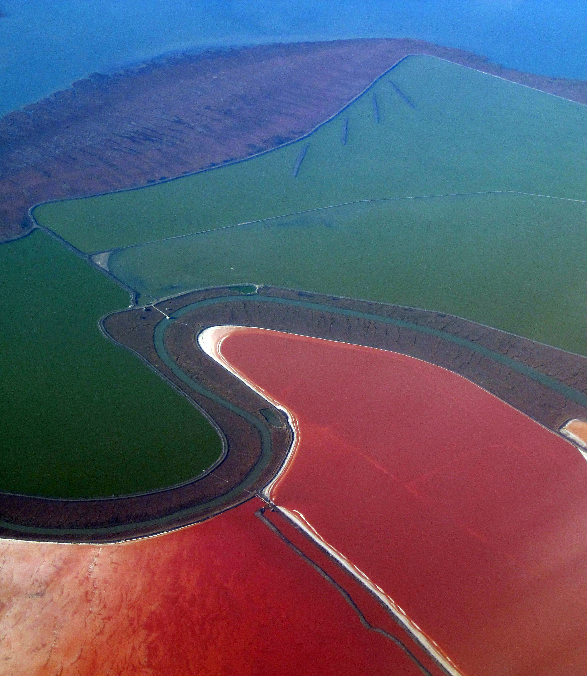
| Lýsing | High power electrical supply towers and lines cross salt ponds of the South Bay. Salt evaporation ponds formed by salt water impounded within levees in former tidelands on the shores of San Francisco Bay. There are many of these ponds surrounding the South Bay. As the water evaporates, micro-organisms of several kinds come to predominate and change the color of the water. First come green algae, then darkening as orange brine shrimp predominate. Finally red predominates as dunaliella salina, a micro-algae containing high amounts of beta-carotene (itself with high commercial value), predominates. Other organisms can also change the hue of each pond. Colors include red, green, orange and yellow, brown and blue. Finally, when the water is evaporated, the white of salt alone remains. This is harvested with machines, and the process repeats. |
| Dagsetning | |
| Uppruni |
|
| Höfundarréttarhafi | Doc Searls from Santa Barbara, USA |
| Object location | | View this and other nearby images on: OpenStreetMap |
|---|
Leyfisupplýsingar:
This file is licensed under the Creative Commons Attribution-Share Alike 2.0 Generic license.
- Þér er frjálst:
- að deila – að afrita, deila og yfirfæra verkið
- að blanda – að breyta verkinu
- Undir eftirfarandi skilmálum:
- tilvísun höfundarréttar – Þú verður að tilgreina viðurkenningu á höfundarréttindum, gefa upp tengil á notkunarleyfið og gefa til kynna ef breytingar hafa verið gerðar. Þú getur gert þetta á einhvern ásættanlegan máta, en ekki á nokkurn þann hátt sem bendi til þess að leyfisveitandinn styðji þig eða notkun þína á verkinu.
- Deila eins – Ef þú breytir, yfirfærir eða byggir á þessu efni, þá mátt þú eingöngu dreifa því verki með sama eða svipuðu leyfi og upprunalega verkið er með.
| This image, originally posted to Flickr, was reviewed on January 22, 2010 by the administrator or reviewer File Upload Bot (Magnus Manske), who confirmed that it was available on Flickr under the stated license on that date. |
Breytingaskrá skjals
Smelltu á dagsetningu eða tímasetningu til að sjá hvernig hún leit þá út.
| Dagsetning/Tími | Smámynd | Víddir | Notandi | Athugasemd | |
|---|---|---|---|---|---|
| núverandi | 22. janúar 2010 kl. 21:00 | | 2.376 × 2.736 (4,52 MB) | File Upload Bot (Magnus Manske) | {{Information |Description=High power electrical supply towers and lines crosss salt ponds of the South Bay. Salt evaporation ponds formed by salt water impounded within levees in former tidelands on the shores of San Francisco Bay. There are many of thes |
Skráartenglar
Eftirfarandi síða notar þessa skrá:
Altæk notkun skráar
Eftirfarandi wikar nota einnig þessa skrá:
- Notkun á de.wikipedia.org
- Notkun á en.wikipedia.org
- Notkun á it.wikipedia.org
- Notkun á oc.wikipedia.org
- Notkun á ru.wikipedia.org
- Notkun á uk.wikipedia.org
- Notkun á vi.wikipedia.org
- Notkun á zh.wikipedia.org