Mynd:Italy 1000 AD.svg

Stærð þessarar PNG forskoðunar á SVG skránni: 418 × 600 mynddílar. Aðrar upplausnir: 167 × 240 mynddílar | 334 × 480 mynddílar | 535 × 768 mynddílar | 713 × 1.024 mynddílar | 1.427 × 2.048 mynddílar | 565 × 811 mynddílar.
Upphafleg skrá (SVG-skrá, að nafni til 565 × 811 mynddílar, skráarstærð: 861 KB)
Lýsing
| Lýsing |
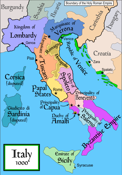
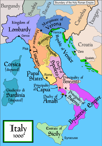
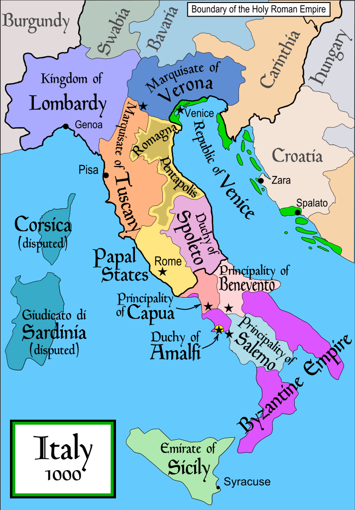
English: Political map of Italy in 1000 AD (CE). Created by MapMaster.
Part of a series of maps on the history of Italy:
|
| Dagsetning | 17. nóvember 2006 (original upload date) |
| Uppruni | No machine-readable source provided. Own work assumed (based on copyright claims). |
| Höfundarréttarhafi | No machine-readable author provided. MapMaster assumed (based on copyright claims). |
| Aðrar útgáfur |
[]
SVG:
PNG:
|


|
This SVG file contains embedded text that can be translated into your language, using any capable SVG editor, text editor or the SVG Translate tool. For more information see: About translating SVG files. |
References
- Bjorklund, Oddvar; Holmboe, Haakon; Rohr, Anders (1970) Historical Atlas of the World, Barnes & Noble, NY, SBN: 389-00253-4.
- This map from Allyn & Bacon, Longman, textbook publishers.
- This map of the w:en:Holy Roman Empire
- A map from Attilios
- This map of 1050 AD Italy, from the 1923 The Historical Atlas by William R. Shepherd
- This map of 1000 AD Italy from Fordham University, adapted from Muir's Historical Atlas, (1911).
In addition, a number of other sources were consulted in an effort to determine the following matters:
- The extent of Venetian control over the cities of Dalmatia such as Zara and Spalato. Although the Venetians had been pushed off the mainland earlier, in the period around the year 1000, the Venetians made an effort to recover these cities.
- The extent of Saracen control over Corsica and Sardinia. Information is sparse. The apparent situation is that the Muslims had several bases on the coasts of these islands, but did not control the countryside (such as they did in Sicily).
- Whether or not the principalities of Capua and Benevento were separate states in the year 1000. Based on lists of their rulers (various Pandulfs and Landulfs), the answer seems to be "yes".
- Who controlled the Balkans on the southeastern border of the Kingdom of Croatia. Candidates include Bulgaria, the Byzantine Empire, Croatia, and Serbia.
As noted, there is significant disagreement among sources on these questions.
This map was commissioned by Attilios, and there is also a discussion to be found on MapMaster's English talk page.
Leyfisupplýsingar:
I, the copyright holder of this work, hereby publish it under the following license:

|
Gefið er leyfi til að afrita, dreifa og/eða breyta þessu skjali samkvæmt Frjálsa GNU Free Documentation License, útgáfu 1.2 eða nýrri, sem gefið er út af Frjálsu hugbúnaðarstofnuninni með engum breytingum þar á. Afrit af leyfinu er innifalið í kaflanum GNU Free Documentation License. |
| Þessi skrá er með Creative Commons Tilvísun-DeilaEins 3.0 Óstaðfært notkunarleyfi. | ||
| ||
| This licensing tag was added to this file as part of the GFDL licensing update. |
derivative works
Derivative works of this file: Italya MS 1000.svg
Breytingaskrá skjals
Smelltu á dagsetningu eða tímasetningu til að sjá hvernig hún leit þá út.
| Dagsetning/Tími | Smámynd | Víddir | Notandi | Athugasemd | |
|---|---|---|---|---|---|
| núverandi | 17. apríl 2007 kl. 19:50 | | 565 × 811 (861 KB) | MapMaster | Some further changes |
| 19. febrúar 2007 kl. 05:10 |  | 565 × 811 (824 KB) | MapMaster | changes to ensure consistency with my other Italy maps | |
| 25. nóvember 2006 kl. 05:39 |  | 565 × 811 (823 KB) | MapMaster | Improved map. | |
| 18. nóvember 2006 kl. 14:44 |  | 565 × 811 (827 KB) | MapMaster | Improved (I hope) version based on recommendations from Attilios. | |
| 17. nóvember 2006 kl. 21:50 |  | 565 × 811 (768 KB) | MapMaster | Political map of Italy in 1000 AD (CE). |
Skráartenglar
Eftirfarandi síða notar þessa skrá:
Altæk notkun skráar
Eftirfarandi wikar nota einnig þessa skrá:
- Notkun á an.wikipedia.org
- Notkun á ar.wikipedia.org
- Notkun á ast.wikipedia.org
- Notkun á azb.wikipedia.org
- Notkun á az.wikipedia.org
- Notkun á bg.wikipedia.org
- Notkun á bn.wikipedia.org
- Notkun á bs.wikipedia.org
- Notkun á ckb.wikipedia.org
- Notkun á cs.wikipedia.org
- Notkun á da.wikipedia.org
- Notkun á de.wikipedia.org
- Notkun á el.wikipedia.org
- Notkun á en.wikipedia.org
- Lombards
- Pope Stephen IX
- Otto III, Holy Roman Emperor
- Otto II, Holy Roman Emperor
- Salerno
- Benevento
- Emirate
- Italian city-states
- List of historical states of Italy
- List of state leaders in the 10th century
- Duchy of Spoleto
- Duchy of Benevento
- Kalbids
- Guaimar IV of Salerno
- Rainulf Drengot
- Duchy of Amalfi
- Emirate of Sicily
- Sergius IV of Naples
Skoða frekari altæka notkun þessarar skráar.