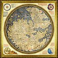
Mynd:FraMauroDetailedMap.jpg

Stærð þessarar forskoðunar: 600 × 600 mynddílar Aðrar upplausnir: 240 × 240 mynddílar | 480 × 480 mynddílar | 768 × 768 mynddílar | 1.024 × 1.024 mynddílar | 2.048 × 2.048 mynddílar | 5.000 × 5.000 mynddílar.
Upphafleg skrá (5.000 × 5.000 mynddílar, skráarstærð: 13,22 MB, MIME-gerð: image/jpeg)
Breytingaskrá skjals
Smelltu á dagsetningu eða tímasetningu til að sjá hvernig hún leit þá út.
| Dagsetning/Tími | Smámynd | Víddir | Notandi | Athugasemd | |
|---|---|---|---|---|---|
| núverandi | 22. ágúst 2022 kl. 12:49 |  | 5.000 × 5.000 (13,22 MB) | Mike Krüger | higher resolution |
| 1. september 2017 kl. 16:45 |  | 2.255 × 2.245 (10,61 MB) | Amphioxi | Reverted to version as of 10:02, 1 May 2007 (UTC), due to incorrect rotation. | |
| 13. júní 2017 kl. 21:12 |  | 2.248 × 2.240 (10,57 MB) | SteinsplitterBot | Bot: Image rotated by 180° | |
| 1. maí 2007 kl. 10:02 |  | 2.255 × 2.245 (10,61 MB) | World Imaging | {{Information |Description=Fra Mauro map (1460) |Source="The Fra Mauro map" |Date=2006 |Author=Piero Falchetta }} |
Skráartenglar
Það eru engar síður sem nota þessa skrá.
Altæk notkun skráar
Eftirfarandi wikar nota einnig þessa skrá:
- Notkun á ca.wikipedia.org
- Notkun á de.wikipedia.org
- Notkun á en.wikipedia.org
- Notkun á es.wikipedia.org
- Notkun á fa.wikipedia.org
- Notkun á fr.wikipedia.org
- Notkun á hr.wikipedia.org
- Notkun á hu.wikipedia.org
- Notkun á id.wikipedia.org
- Notkun á nl.wikipedia.org
- Notkun á pnb.wikipedia.org
- Notkun á pt.wikipedia.org
- Notkun á ru.wikipedia.org
- Notkun á sh.wikipedia.org
- Notkun á sv.wikipedia.org
- Notkun á tr.wikipedia.org
- Notkun á uk.wikipedia.org
- Notkun á ur.wikipedia.org
- Notkun á www.wikidata.org

