Mynd:Duchy of Prussia.svg

Stærð þessarar PNG forskoðunar á SVG skránni: 610 × 588 mynddílar. Aðrar upplausnir: 249 × 240 mynddílar | 498 × 480 mynddílar | 797 × 768 mynddílar | 1.062 × 1.024 mynddílar | 2.125 × 2.048 mynddílar.
Upphafleg skrá (SVG-skrá, að nafni til 610 × 588 mynddílar, skráarstærð: 55 KB)
Lýsing
| Lýsing |
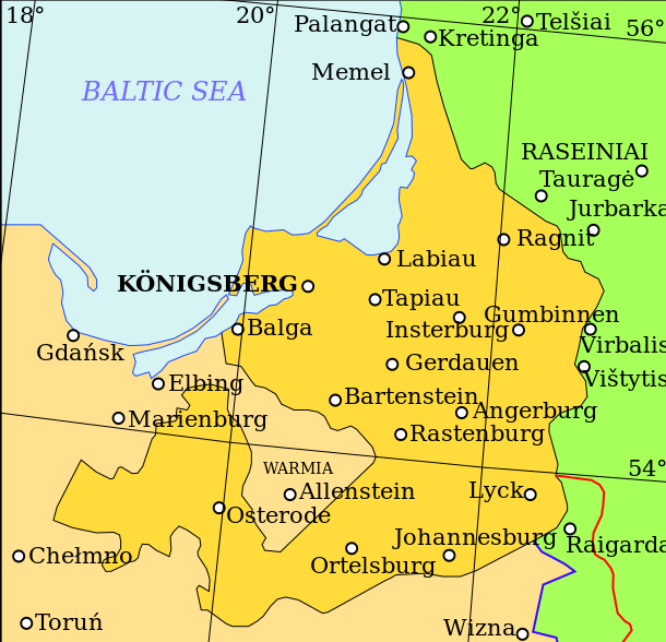
English: Map showing the Duchy of Prussia, at an indeterminable date. Place names inside the Duchy are given in German, as are Elbing and Marienburg. Other names are modern.
Territory of the Duchy of Prussia Territory of the Kingdom of Poland before the Union of Lublin Territory of the Grand Duchy of Lithuania before the Union of Lublin Polish-Lithuanian border before the Union of Lublin Polish-Lithuanian border after the Union of Lublin |
| Dagsetning | |
| Uppruni | Own work based on: (litháíska) (2001) Lietuvos istorijos atlasas, Vilníus: Vaga, pp. 16—17 |
| Höfundarréttarhafi | Grandiose |
| Aðrar útgáfur |
|
| SVG genesis |

| File | Type | Details |
|---|---|---|
| File:Polish-Lithuania map (1450-1600).svg | Large SVG | Map showing conflicts and territorial changes on the Polish-Lithuanian—Russian border, 1450–1600 |
| File:Duchy of Prussia.svg | Small SVG | Map of the Duchy of Prussia |
| File:Livonian war map (1558-1560).svg | Small SVG | Map showing campaigns in Livonia, 1558–1560. |
| File:Map of Poland and Lithuania after the Union of Lublin (1569).svg | Large SVG | Map of the w:Polish-Lithuanian Commonwealth after the Union of Lublin in 1569. |
| File:Livonian war map (1570-1577).svg | Small SVG | Map showing areas of Russian and Polish-Lithuanian forces, 1570–1577. |
| File:Campaigns of Stefan Batory.svg | Small SVG | Map of the campaign of Stefan Batory in Livonia (1575–1580). |
| File:Map of Poland and Lithuania in 1600.svg | Small SVG | Map of Livonia in 1600 |
| See also: User:Halibutt/maps, by Halibutt (spjall · framlög). | ||
.svg)
.svg)
.svg)
.svg)
Leyfisupplýsingar:
I, the copyright holder of this work, hereby publish it under the following license:
Þessi skrá er með Creative Commons Tilvísun-DeilaEins 3.0 Óstaðfært notkunarleyfi.
- Þér er frjálst:
- að deila – að afrita, deila og yfirfæra verkið
- að blanda – að breyta verkinu
- Undir eftirfarandi skilmálum:
- tilvísun höfundarréttar – Þú verður að tilgreina viðurkenningu á höfundarréttindum, gefa upp tengil á notkunarleyfið og gefa til kynna ef breytingar hafa verið gerðar. Þú getur gert þetta á einhvern ásættanlegan máta, en ekki á nokkurn þann hátt sem bendi til þess að leyfisveitandinn styðji þig eða notkun þína á verkinu.
- Deila eins – Ef þú breytir, yfirfærir eða byggir á þessu efni, þá mátt þú eingöngu dreifa því verki með sama eða svipuðu leyfi og upprunalega verkið er með.
Breytingaskrá skjals
Smelltu á dagsetningu eða tímasetningu til að sjá hvernig hún leit þá út.
| Dagsetning/Tími | Smámynd | Víddir | Notandi | Athugasemd | |
|---|---|---|---|---|---|
| núverandi | 20. apríl 2011 kl. 10:07 | | 610 × 588 (55 KB) | Grandiose | Correct spelling |
| 19. apríl 2011 kl. 12:44 |  | 610 × 588 (54 KB) | Grandiose | Lines on longitude and latitude; other important fixes. | |
| 19. apríl 2011 kl. 12:36 |  | 610 × 588 (1,1 MB) | Grandiose | Fix text locations | |
| 19. apríl 2011 kl. 12:33 |  | 610 × 588 (1,1 MB) | Grandiose |
Skráartenglar
Eftirfarandi síða notar þessa skrá:
Altæk notkun skráar
Eftirfarandi wikar nota einnig þessa skrá:
- Notkun á ar.wikipedia.org
- Notkun á ast.wikipedia.org
- Notkun á br.wikipedia.org
- Notkun á ca.wikipedia.org
- Notkun á cs.wikipedia.org
- Notkun á de.wikipedia.org
- Notkun á el.wikipedia.org
- Notkun á en.wikipedia.org
- Notkun á eu.wikipedia.org
- Notkun á fa.wikipedia.org
- Notkun á fi.wikipedia.org
- Notkun á gl.wikipedia.org
- Notkun á he.wikipedia.org
- Notkun á hr.wikipedia.org
- Notkun á hu.wikipedia.org
- Notkun á it.wikipedia.org
- Notkun á ja.wikipedia.org
- Notkun á ko.wikipedia.org
- Notkun á lt.wikipedia.org
- Notkun á mk.wikipedia.org
- Notkun á rue.wikipedia.org
- Notkun á ru.wikipedia.org
- Notkun á sc.wikipedia.org
- Notkun á sh.wikipedia.org
- Notkun á sv.wikipedia.org
- Notkun á th.wikipedia.org
- Notkun á tr.wikipedia.org
- Notkun á uk.wikipedia.org
- Notkun á vi.wikipedia.org
- Notkun á www.wikidata.org
- Notkun á zh.wikipedia.org