Mynd:Colonizationoftheamericas.png

Stærð þessarar forskoðunar: 463 × 599 mynddílar Aðrar upplausnir: 185 × 240 mynddílar | 470 × 608 mynddílar.
Upphafleg skrá (470 × 608 mynddílar, skráarstærð: 19 KB, MIME-gerð: image/png)
Lýsing
| Lýsing |
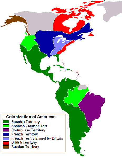
Map of European colonization of the Americas in 1750 Source file: Based upon en:Image:Spanish colonization of the Americas.png by Satesclop |
| Dagsetning | 5. nóvember 2006 (original upload date) |
| Uppruni | Transferred from en.wikipedia to Commons. |
| Höfundarréttarhafi | 24630 at enska Wikipedia |
| Aðrar útgáfur | Blank version : Image:Colonizationoftheamericas-blank.png, Arabic |

|
This historical map image could be re-created using vector graphics as an SVG file. This has several advantages; see Commons:Media for cleanup for more information. If an SVG form of this image is available, please upload it and afterwards replace this template with
{{vector version available|new image name}}.
It is recommended to name the SVG file “Colonizationoftheamericas.svg”—then the template Vector version available (or Vva) does not need the new image name parameter. |
Leyfisupplýsingar:
| This work has been released into the public domain by its author, 24630 at enska Wikipedia. This applies worldwide. In some countries this may not be legally possible; if so: 24630 grants anyone the right to use this work for any purpose, without any conditions, unless such conditions are required by law. |
Original upload log
The original description page was here. All following user names refer to en.wikipedia.
- 2006-11-05 21:59 24630 470×608×8 (19328 bytes) Map of European colonization of the Americas in 1750 '''Source file''': Based upon [[:Image:Spanish colonization of the Americas.png]] by [[User:Satesclop|Satesclop]]
Breytingaskrá skjals
Smelltu á dagsetningu eða tímasetningu til að sjá hvernig hún leit þá út.
| Dagsetning/Tími | Smámynd | Víddir | Notandi | Athugasemd | |
|---|---|---|---|---|---|
| núverandi | 30. mars 2007 kl. 13:26 | | 470 × 608 (19 KB) | Liftarn | {{Information |Description=Map of European colonization of the Americas in 1750 '''Source file''': Based upon en::Image:Spanish colonization of the Americas.png by Satesclop |Source=Originally from [http://en.wikipedia.org en. |
Skráartenglar
Eftirfarandi síða notar þessa skrá:
Altæk notkun skráar
Eftirfarandi wikar nota einnig þessa skrá:
- Notkun á ar.wikipedia.org
- Notkun á az.wikipedia.org
- Xristofor Kolumb
- Ernan Kortes
- Fernan Magellan
- Frensis Dreyk
- Jak Kartye
- Ceyms Kuk
- Kürən Erik
- Leyf Eriksson
- Ameriqo Vespuççi
- Henri Hudzon
- Qriqori Şelixov
- Martin Frobişer
- Xuan Ponse de Leon
- Pedro de Valdivia
- Dieqo de Almaqro
- Fransisko Pizarro
- Sebastian de Belalcazar
- Vasko Nunyes de Balboa
- Vitus Berinq
- Pedro Alvarez Kabral
- Con Franklin
- Hernando de Soto
- Çarlz Vilks
- Con Smit
- Samuel de Şamplen
- Con Deyvis (səyyah)
- Şablon:Amerikanı kəşf edənlər
- Notkun á be.wikipedia.org
- Хрыстафор Калумб
- Вялікія геаграфічныя адкрыцці
- Джэймс Кук
- Эрнан Картэс
- Фернан Магелан
- Жак Карцье
- Лейф Эрыксан
- Амерыга Веспучы
- Фрэнсіс Дрэйк
- Эйрык Рыжы
- Вітус Берынг
- Гунб’ёрн Ульфсан
- Франсіска Пісара
- Джон Франклін
- Дыега дэ Альмагра
- Генры Гудзон
- Сямён Іванавіч Дзяжнёў
- Педра дэ Вальдывія
- Уільям Бафін
- Шаблон:Даследчыкі Амерыкі
- Эрнанда дэ Сота
- Джордж Ванкувер
Skoða frekari altæka notkun þessarar skráar.