Mynd:Carpetright store after Tottenham riots.jpg
Upphafleg skrá (4.000 × 3.000 mynddílar, skráarstærð: 1,95 MB, MIME-gerð: image/jpeg)
Lýsing
| Lýsing |
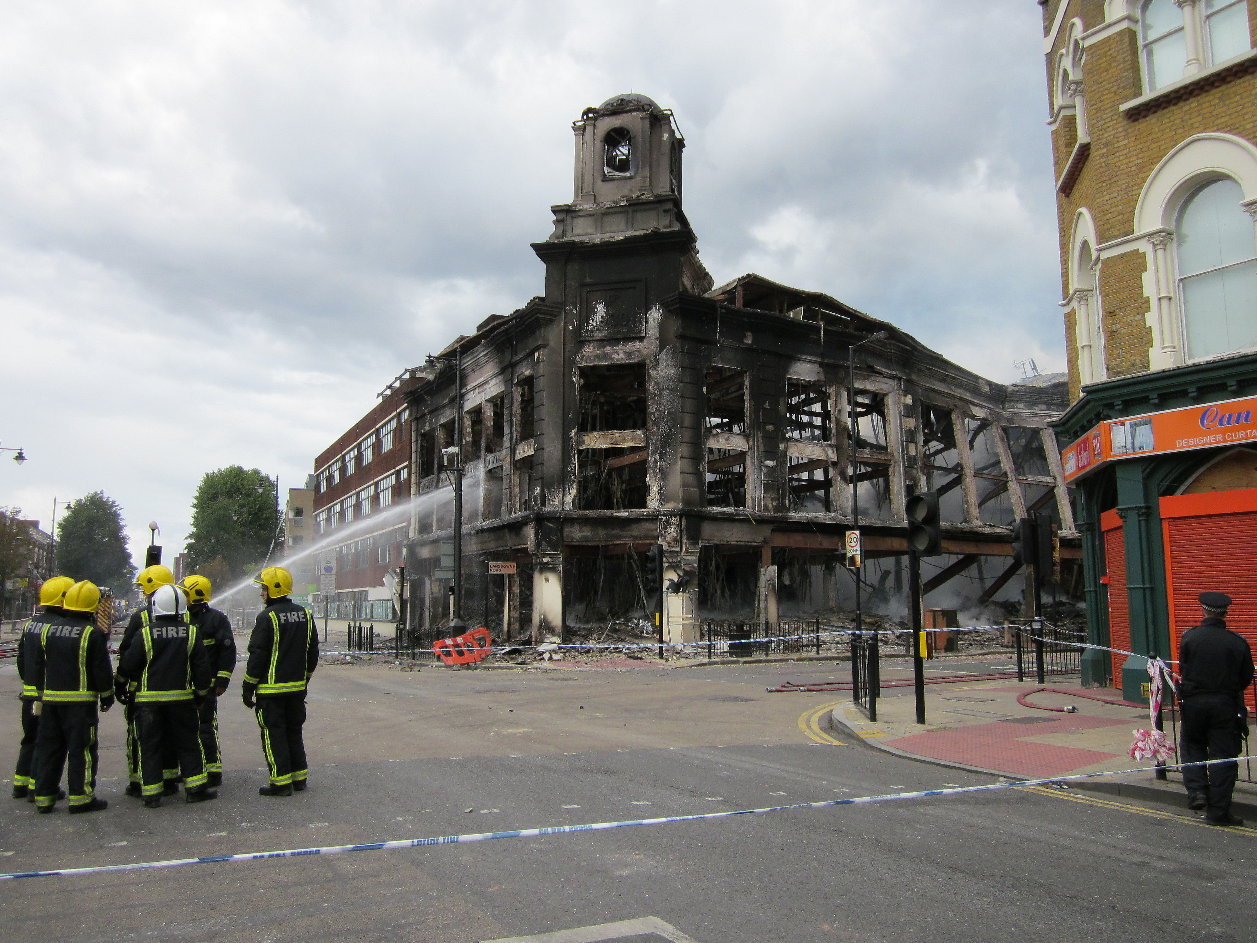
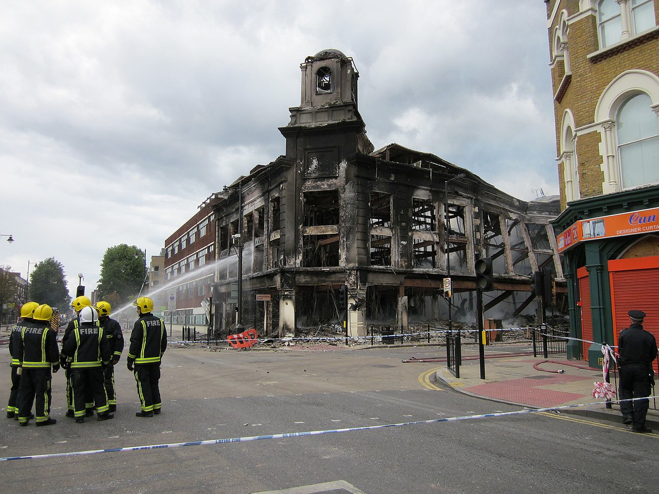
7 August 2011. 2:07 pm. Zena and I walked to the High Road to see the dreadful damage. And spoke to some of the other residents who'd come out. Much of the High Road was taped off by the Police. We weren't allowed near the former Co-op and Carpet Right building which was still smouldering and looked unsafe. ______________________________________ Links § Click for a few seconds of video. § Aerial view of where this photo was taken. § Liz Ixer's photo of the building only a few months before in February 2011. § Gareth Bedford's set of photos - 7 August. |
| Dagsetning | |
| Uppruni | Firefighters - High Road Tottenham & Lansdowne Road |
| Höfundarréttarhafi | Alan Stanton |
| Camera location | | View this and other nearby images on: OpenStreetMap |
|---|
Leyfisupplýsingar:
- Þér er frjálst:
- að deila – að afrita, deila og yfirfæra verkið
- að blanda – að breyta verkinu
- Undir eftirfarandi skilmálum:
- tilvísun höfundarréttar – Þú verður að tilgreina viðurkenningu á höfundarréttindum, gefa upp tengil á notkunarleyfið og gefa til kynna ef breytingar hafa verið gerðar. Þú getur gert þetta á einhvern ásættanlegan máta, en ekki á nokkurn þann hátt sem bendi til þess að leyfisveitandinn styðji þig eða notkun þína á verkinu.
- Deila eins – Ef þú breytir, yfirfærir eða byggir á þessu efni, þá mátt þú eingöngu dreifa því verki með sama eða svipuðu leyfi og upprunalega verkið er með.
| This image, originally posted to Flickr, was reviewed on 9 August 2011 by the administrator or reviewer Warfieldian, who confirmed that it was available on Flickr under the stated license on that date. |
Breytingaskrá skjals
Smelltu á dagsetningu eða tímasetningu til að sjá hvernig hún leit þá út.
| Dagsetning/Tími | Smámynd | Víddir | Notandi | Athugasemd | |
|---|---|---|---|---|---|
| núverandi | 8. ágúst 2011 kl. 20:02 | | 4.000 × 3.000 (1,95 MB) | Yohan euan o4 | {{Information |Description='''7 August 2011. 2:07 pm.''' Zena and I walked to the High Road to see the dreadful damage. And spoke to some of the other residents who'd come out. Much of the High Road was taped off by the Police. We weren't allowed near |
Skráartenglar
Eftirfarandi síða notar þessa skrá:
Altæk notkun skráar
Eftirfarandi wikar nota einnig þessa skrá:
- Notkun á ar.wikipedia.org
- Notkun á bg.wikipedia.org
- Notkun á ca.wikipedia.org
- Notkun á cs.wikipedia.org
- Notkun á cy.wikipedia.org
- Notkun á de.wikipedia.org
- Notkun á en.wikipedia.org
- Notkun á es.wikipedia.org
- Notkun á et.wikipedia.org
- Notkun á fa.wikipedia.org
- Notkun á fi.wikipedia.org
- Notkun á fr.wikipedia.org
- Notkun á ga.wikipedia.org
- Notkun á gl.wikipedia.org
- Notkun á he.wikipedia.org
- Notkun á id.wikipedia.org
- Notkun á it.wikipedia.org
- Notkun á ja.wikipedia.org
- Notkun á jv.wikipedia.org
- Notkun á ko.wikipedia.org
- Notkun á lt.wikipedia.org
- Notkun á mk.wikipedia.org
- Notkun á ms.wikipedia.org
- Notkun á nl.wikipedia.org
- Notkun á no.wikipedia.org
- Notkun á pl.wikipedia.org
- Notkun á pt.wikipedia.org
- Notkun á ro.wikipedia.org
- Notkun á ru.wikipedia.org
- Notkun á simple.wikipedia.org
- Notkun á sv.wikipedia.org
Skoða frekari altæka notkun þessarar skráar.