Mynd:British Isles.svg

Stærð þessarar PNG forskoðunar á SVG skránni: 361 × 600 mynddílar. Aðrar upplausnir: 144 × 240 mynddílar | 289 × 480 mynddílar | 462 × 768 mynddílar | 616 × 1.024 mynddílar | 1.232 × 2.048 mynddílar | 1.300 × 2.160 mynddílar.
Upphafleg skrá (SVG-skrá, að nafni til 1.300 × 2.160 mynddílar, skráarstærð: 154 KB)
Lýsing
| Lýsing |
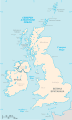
An SVG map of the British Isles, with the largest islands and archipelagos labelled. Always considered part of the British Isles
Sometimes considered part of the British Isles
Other lands |
| Uppruni | eigin skrá |
| Höfundarréttarhafi | Smurrayinchester |
| SVG genesis | This W3C-invalid map was created with unknown tool. This map is translated using SVG switch elements: all translations are stored in the same file. |
}
Leyfisupplýsingar:
I, the copyright holder of this work, hereby publish it under the following license:

|
Gefið er leyfi til að afrita, dreifa og/eða breyta þessu skjali samkvæmt Frjálsa GNU Free Documentation License, útgáfu 1.2 eða nýrri, sem gefið er út af Frjálsu hugbúnaðarstofnuninni með engum breytingum þar á. Afrit af leyfinu er innifalið í kaflanum GNU Free Documentation License. |
| Þessi skrá er með Creative Commons Tilvísun-DeilaEins 3.0 Óstaðfært notkunarleyfi. | ||
| ||
| This licensing tag was added to this file as part of the GFDL licensing update. |
Derivative works
-
 македонски
 -
 Flag map (1801–1922)


derivative works
Derivative works of this file: British Isles mk.svg
Breytingaskrá skjals
Smelltu á dagsetningu eða tímasetningu til að sjá hvernig hún leit þá út.
| Dagsetning/Tími | Smámynd | Víddir | Notandi | Athugasemd | |
|---|---|---|---|---|---|
| núverandi | 10. febrúar 2019 kl. 15:33 | | 1.300 × 2.160 (154 KB) | MSG17 | Uploaded from SVG Translate. |
| 13. október 2018 kl. 14:56 |  | 1.300 × 2.160 (141 KB) | Seb35 | small bug: translations have to be before the default text else the PNG rendering selects the default text | |
| 13. október 2018 kl. 14:51 |  | 1.300 × 2.160 (141 KB) | Seb35 | added French translation | |
| 20. maí 2014 kl. 14:50 |  | 1.300 × 2.160 (135 KB) | NikNaks | More cleaning. File could still be a lot smaller than it currently is | |
| 20. maí 2014 kl. 03:02 |  | 1.300 × 2.160 (152 KB) | NikNaks | Malay translation | |
| 20. maí 2014 kl. 02:36 |  | 1.300 × 2.160 (148 KB) | NikNaks | Cleaning unfortunately lost detail. Will have to return to later | |
| 20. maí 2014 kl. 02:22 |  | 1.297 × 2.160 (37 KB) | NikNaks | Attempting to clean up the file before translation | |
| 20. ágúst 2006 kl. 12:37 |  | 1.297 × 2.160 (196 KB) | Smurrayinchester | An SVG map of the British Isles, with the largest islands and archipelagos labeled. {{legend|#fff0de|Always considered part of the British Isles|border=#ffffff}} {{legend|#ffb380|Sometimes considered part of the British Isles|border=#ffffff}} {{legend|#e |
Skráartenglar
Það eru engar síður sem nota þessa skrá.
Altæk notkun skráar
Eftirfarandi wikar nota einnig þessa skrá:
- Notkun á ar.wikipedia.org
- Notkun á az.wikipedia.org
- Notkun á be.wikipedia.org
- Notkun á bs.wikipedia.org
- Notkun á ceb.wikipedia.org
- Notkun á ckb.wikipedia.org
- Notkun á da.wikipedia.org
- Notkun á en.wikipedia.org
- Geography of the Isle of Man
- Burhou
- Talk:International Football Association Board
- Module:Location map/data/British Isles/doc
- List of offshore wind farms in the Irish Sea
- Siege of St Andrews Castle
- User:Malpass93/sandbox
- Module:Location map/data/British Isles
- 2014 Senior Open Championship
- 2017 Senior Open Championship
- 2018 Eisenhower Trophy
- User:Grover cleveland/History of the laws of the game/List of IFAB meetings
- User:Grover cleveland/English managers
- 2018 Espirito Santo Trophy
- 1965 European Amateur Team Championship
- 1975 European Amateur Team Championship
- 1981 European Amateur Team Championship
- 1989 European Amateur Team Championship
- 1997 European Amateur Team Championship
- 2005 European Amateur Team Championship
- 2007 European Amateur Team Championship
- 2009 European Amateur Team Championship
- 1971 European Ladies' Team Championship
- 1979 European Ladies' Team Championship
- 1987 European Ladies' Team Championship
- 1991 European Ladies' Team Championship
- 2013 European Ladies' Team Championship
- 2021 European Ladies' Team Championship
- 2022 European Amateur Team Championship
- 2022 European Ladies' Team Championship
- 2013 Senior Open Championship
- 2012 Senior Open Championship
- 2011 Senior Open Championship
- 2008 Senior Open Championship
- 2006 Senior Open Championship
- 2002 Senior British Open
- 2001 Senior British Open
- 2000 Senior British Open
- 2022 Senior Open Championship
- User:Erik Sergeant/sandbox 2
- 2023 Senior Open Championship
- Module:Location map/data/British Isles/sandbox
- Draft:2024 Monoposto Championship
Skoða frekari altæka notkun þessarar skráar.