Mynd:Yokohama Landsat.jpg

Stærð þessarar forskoðunar: 428 × 599 mynddílar Aðrar upplausnir: 171 × 240 mynddílar | 343 × 480 mynddílar | 548 × 768 mynddílar | 731 × 1.024 mynddílar | 1.500 × 2.100 mynddílar.
Upphafleg skrá (1.500 × 2.100 mynddílar, skráarstærð: 803 KB, MIME-gerð: image/jpeg)
Lýsing
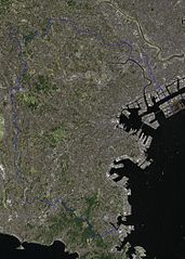
| The Landsat satellite pictures are used for this image. The data came from Global Land Cover Facility (GLCF), and are processed with Kashmir 3D. |
Leyfisupplýsingar:
| I, the copyright holder of this work, release this work into the public domain. This applies worldwide. In some countries this may not be legally possible; if so: I grant anyone the right to use this work for any purpose, without any conditions, unless such conditions are required by law. |
Breytingaskrá skjals
Smelltu á dagsetningu eða tímasetningu til að sjá hvernig hún leit þá út.
| Dagsetning/Tími | Smámynd | Víddir | Notandi | Athugasemd | |
|---|---|---|---|---|---|
| núverandi | 19. apríl 2007 kl. 20:28 | | 1.500 × 2.100 (803 KB) | Pqks758 | |
| 1. apríl 2007 kl. 07:24 |  | 600 × 605 (99 KB) | Pqks758 | {{Landsat}} |
Skráartenglar
Eftirfarandi síða notar þessa skrá:
Altæk notkun skráar
Eftirfarandi wikar nota einnig þessa skrá:
- Notkun á ast.wikipedia.org
- Notkun á es.wikipedia.org
- Notkun á eu.wikipedia.org
- Notkun á ja.wikipedia.org
- Notkun á ko.wikipedia.org
- Notkun á mn.wikipedia.org
- Notkun á pt.wikipedia.org
- Notkun á www.wikidata.org
- Notkun á zh.wikipedia.org