Mynd:Winchester cathedral - geograph.org.uk - 1628919.jpg
Það er engin hærri upplausn til.
Winchester_cathedral_-_geograph.org.uk_-_1628919.jpg (640 × 428 mynddílar, skráarstærð: 188 KB, MIME-gerð: image/jpeg)
Lýsing
| Lýsing |
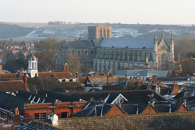
English: Winchester cathedral Taken from the 2nd floor of Hampshire County Council's refurbished offices at E2 Court. The cathedral squats in the valley of the River Itchen, but none the less dominates the city. Started in 1079 by Bishop Walklin, it was consecrated in 1093. The tower fell down in 1107 (thought to be bad luck caused by the burial of the unpopular King William 2nd (Rufus) here in 1100) and was never rebuilt. The nave (this end between the West window and the tower) is the second longest in Europe after St. Peter's in Rome. |
| Dagsetning | |
| Uppruni | From geograph.org.uk |
| Höfundarréttarhafi | Graham Horn |
| Tilvísun höfundarréttar (required by the license) | Graham Horn / Winchester cathedral / |
| Camera location | | View this and other nearby images on: OpenStreetMap |
|---|
_heading:135.00&language=is)
| Object location | | View this and other nearby images on: OpenStreetMap |
|---|
_heading:135.00&language=is)
Leyfisupplýsingar:

|
This image was taken from the Geograph project collection. See this photograph's page on the Geograph website for the photographer's contact details. The copyright on this image is owned by Graham Horn and is licensed for reuse under the Creative Commons Attribution-ShareAlike 2.0 license.
|
This file is licensed under the Creative Commons Attribution-Share Alike 2.0 Generic license.
Tilvísun höfundarréttar: Graham Horn
- Þér er frjálst:
- að deila – að afrita, deila og yfirfæra verkið
- að blanda – að breyta verkinu
- Undir eftirfarandi skilmálum:
- tilvísun höfundarréttar – Þú verður að tilgreina viðurkenningu á höfundarréttindum, gefa upp tengil á notkunarleyfið og gefa til kynna ef breytingar hafa verið gerðar. Þú getur gert þetta á einhvern ásættanlegan máta, en ekki á nokkurn þann hátt sem bendi til þess að leyfisveitandinn styðji þig eða notkun þína á verkinu.
- Deila eins – Ef þú breytir, yfirfærir eða byggir á þessu efni, þá mátt þú eingöngu dreifa því verki með sama eða svipuðu leyfi og upprunalega verkið er með.
Breytingaskrá skjals
Smelltu á dagsetningu eða tímasetningu til að sjá hvernig hún leit þá út.
| Dagsetning/Tími | Smámynd | Víddir | Notandi | Athugasemd | |
|---|---|---|---|---|---|
| núverandi | 4. mars 2011 kl. 14:55 | | 640 × 428 (188 KB) | GeographBot | == {{int:filedesc}} == {{Information |description={{en|1=Winchester cathedral Taken from the 2nd floor of Hampshire County Council's refurbished offices at E2 Court. The cathedral squats in the valley of the River Itchen, but none the less dominates the |
Skráartenglar
Eftirfarandi síða notar þessa skrá:
Altæk notkun skráar
Eftirfarandi wikar nota einnig þessa skrá:
- Notkun á ang.wikipedia.org
- Notkun á az.wikipedia.org
- Notkun á en.wikipedia.org
- Notkun á fi.wikipedia.org
- Notkun á lv.wikipedia.org
- Notkun á vi.wikipedia.org
- Notkun á war.wikipedia.org
- Notkun á wuu.wikipedia.org
- Notkun á zh-min-nan.wikipedia.org