Mynd:White Sea Canal map.png

Stærð þessarar forskoðunar: 699 × 600 mynddílar Aðrar upplausnir: 280 × 240 mynddílar | 560 × 480 mynddílar | 1.000 × 858 mynddílar.
Upphafleg skrá (1.000 × 858 mynddílar, skráarstærð: 351 KB, MIME-gerð: image/png)

|
This locator map image could be re-created using vector graphics as an SVG file. This has several advantages; see Commons:Media for cleanup for more information. If an SVG form of this image is available, please upload it and afterwards replace this template with
{{vector version available|new image name}}.
It is recommended to name the SVG file “White Sea Canal map.svg”—then the template Vector version available (or Vva) does not need the new image name parameter. |
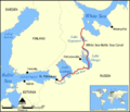
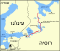
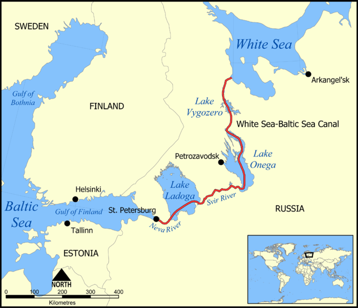
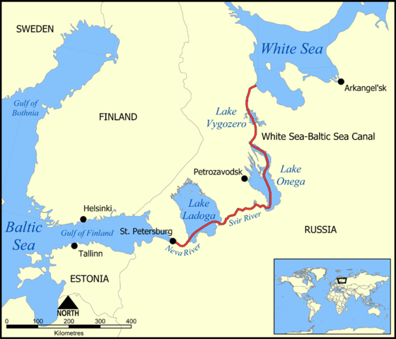
This map shows the route of the White Sea-Baltic Sea Canal ("Belomorkanal") between the White Sea and Baltic Sea. It shows the lakes Vygozero, Onega, and Ladoga, and the Svir' and Neva rivers too.
Created by NormanEinstein, December 6, 2005.
I, the copyright holder of this work, hereby publish it under the following license:

|
Gefið er leyfi til að afrita, dreifa og/eða breyta þessu skjali samkvæmt Frjálsa GNU Free Documentation License, útgáfu 1.2 eða nýrri, sem gefið er út af Frjálsu hugbúnaðarstofnuninni með engum breytingum þar á. Afrit af leyfinu er innifalið í kaflanum GNU Free Documentation License. |
| Þessi skrá er með Creative Commons Tilvísun-DeilaEins 3.0 Óstaðfært notkunarleyfi. | ||
| ||
| This licensing tag was added to this file as part of the GFDL licensing update. |
Derivative works
[]
-
 Deutsch
 -
 English
 -
 français
 -
 hrvatski
 -
 עברית
עברית


Breytingaskrá skjals
Smelltu á dagsetningu eða tímasetningu til að sjá hvernig hún leit þá út.
| Dagsetning/Tími | Smámynd | Víddir | Notandi | Athugasemd | |
|---|---|---|---|---|---|
| núverandi | 6. desember 2005 kl. 17:59 | | 1.000 × 858 (351 KB) | NormanEinstein | This map shows the route of the White Sea-Baltic Sea Canal between the White Sea and Baltic Sea. (Heh heh.) It shows the lakes Vygozero, Onega, and Ladoga, and the Sivr and Neva rivers too. Created by NormanEinstein, December 6, 2005. {{GFDL-self}} [[C |
Skráartenglar
Eftirfarandi síða notar þessa skrá:
Altæk notkun skráar
Eftirfarandi wikar nota einnig þessa skrá:
- Notkun á af.wikipedia.org
- Notkun á ar.wikipedia.org
- Notkun á arz.wikipedia.org
- Notkun á ast.wikipedia.org
- Notkun á bg.wikipedia.org
- Notkun á ca.wikipedia.org
- Notkun á cs.wikipedia.org
- Notkun á da.wikipedia.org
- Notkun á en.wikipedia.org
- Notkun á es.wikipedia.org
- Notkun á fa.wikipedia.org
- Notkun á fr.wikipedia.org
- Notkun á fy.wikipedia.org
- Notkun á hi.wikipedia.org
- Notkun á id.wikipedia.org
- Notkun á incubator.wikimedia.org
- Notkun á it.wikipedia.org
- Notkun á ja.wikipedia.org
- Notkun á ko.wikipedia.org
- Notkun á lt.wikipedia.org
- Notkun á lv.wikipedia.org
- Notkun á mk.wikipedia.org
- Notkun á nl.wikipedia.org
- Notkun á no.wikipedia.org
- Notkun á pl.wikipedia.org
- Notkun á pt.wikipedia.org
- Notkun á qu.wikipedia.org
- Notkun á ro.wikipedia.org
- Notkun á ru.wikipedia.org
- Notkun á simple.wikipedia.org
- Notkun á sl.wikipedia.org
Skoða frekari altæka notkun þessarar skráar.