Mynd:Wfm firth of forth.jpg

Stærð þessarar forskoðunar: 800 × 593 mynddílar Aðrar upplausnir: 320 × 237 mynddílar | 640 × 474 mynddílar | 1.024 × 758 mynddílar | 1.280 × 948 mynddílar.
Upphafleg skrá (1.280 × 948 mynddílar, skráarstærð: 289 KB, MIME-gerð: image/jpeg)
Lýsing
| Lýsing |
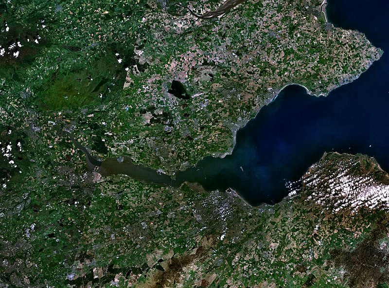
English: The Firth of the river Forth, on the east coast of Scotland. The two forth bridges are visible near the centre of the frame. Stirling is at the extreme left side. |
| Dagsetning | 3. ágúst 2005 (upload date) |
| Uppruni | Satellite imagery taken by screenshot from NASA World Wind software |
| Höfundarréttarhafi | NASA |
Leyfisupplýsingar:
| This image is in the public domain because it is a screenshot from NASA’s globe software World Wind using a public domain layer, such as Blue Marble, MODIS, Landsat, SRTM, USGS or GLOBE.
|
 |
Breytingaskrá skjals
Smelltu á dagsetningu eða tímasetningu til að sjá hvernig hún leit þá út.
| Dagsetning/Tími | Smámynd | Víddir | Notandi | Athugasemd | |
|---|---|---|---|---|---|
| núverandi | 3. ágúst 2005 kl. 09:38 | | 1.280 × 948 (289 KB) | Finlay McWalter | The Firth of the river Forth, on the east coast of Scotland. The two forth bridges are visible near the centre of the frame. Stirling is at the extreme left side. Image made with NASA World Wind. {{PD-USGov-NASA}} category:satellite photos |
Skráartenglar
Eftirfarandi síða notar þessa skrá:
Altæk notkun skráar
Eftirfarandi wikar nota einnig þessa skrá:
- Notkun á ar.wikipedia.org
- Notkun á be.wikipedia.org
- Notkun á bg.wikipedia.org
- Notkun á br.wikipedia.org
- Notkun á ca.wikipedia.org
- Notkun á ceb.wikipedia.org
- Notkun á cs.wikipedia.org
- Notkun á cy.wikipedia.org
- Notkun á de.wikipedia.org
- Notkun á el.wikipedia.org
- Notkun á en.wikipedia.org
- Notkun á en.wikivoyage.org
- Notkun á eo.wikipedia.org
- Notkun á es.wikipedia.org
- Notkun á et.wikipedia.org
- Notkun á eu.wikipedia.org
- Notkun á fa.wikipedia.org
- Notkun á fr.wikipedia.org
- Notkun á ga.wikipedia.org
- Notkun á gd.wikipedia.org
- Notkun á ha.wikipedia.org
- Notkun á he.wikipedia.org
- Notkun á hi.wikipedia.org
- Notkun á ia.wikipedia.org
- Notkun á it.wikipedia.org
- Notkun á it.wikivoyage.org
- Notkun á ja.wikipedia.org
- Notkun á kbd.wikipedia.org
- Notkun á lt.wikipedia.org
- Notkun á mt.wikipedia.org
- Notkun á nl.wikipedia.org
- Notkun á nn.wikipedia.org
- Notkun á no.wikipedia.org
- Notkun á pl.wikipedia.org
- Notkun á pt.wikipedia.org
- Notkun á ro.wikipedia.org
- Notkun á ru.wikipedia.org
- Notkun á sco.wikipedia.org
Skoða frekari altæka notkun þessarar skráar.