Mynd:View of Amsterdam.JPG
Stærð þessarar forskoðunar: 800 × 582 mynddílar Aðrar upplausnir: 320 × 233 mynddílar | 640 × 466 mynddílar | 1.024 × 745 mynddílar | 1.280 × 931 mynddílar | 2.560 × 1.863 mynddílar | 3.341 × 2.431 mynddílar.
Upphafleg skrá (3.341 × 2.431 mynddílar, skráarstærð: 3,18 MB, MIME-gerð: image/jpeg)
Lýsing
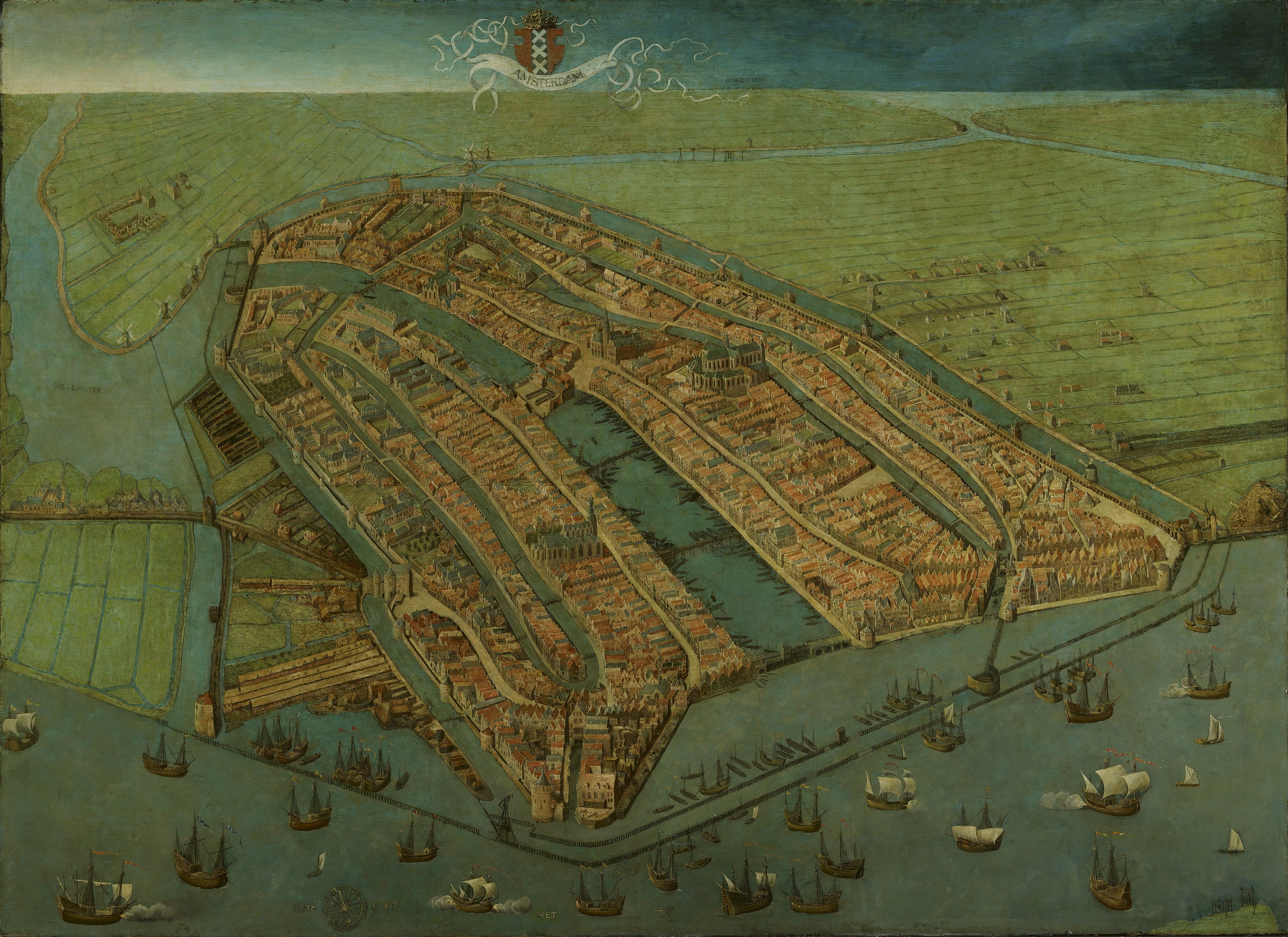
| Cornelis Anthonisz.: Bird’s-eye View of Amsterdam
|
|||||||||||||||||||||||||||
|---|---|---|---|---|---|---|---|---|---|---|---|---|---|---|---|---|---|---|---|---|---|---|---|---|---|---|---|
| Listamaður |
|
 | |||||||||||||||||||||||||
| Titill |
enska:
Bird's-eye view of Amsterdam |
||||||||||||||||||||||||||
| Object type | painting | ||||||||||||||||||||||||||
| Genre |
cityscape |
||||||||||||||||||||||||||
| Lýsing |
Oldest surviving map of Amsterdam, showing the city's finished medieval walls, towers and gates. Like in most old maps of Amsterdam the city is shown from the IJ, so that the view is directed to the south rather than the north. |
||||||||||||||||||||||||||
| Dagsetning |
1538 / 1530 - 1539 |
||||||||||||||||||||||||||
| Miðill |
oil on panel |
||||||||||||||||||||||||||
| Stærðir |
hæð: 116 cm |
||||||||||||||||||||||||||
| Collection |
|
||||||||||||||||||||||||||
| Accession number |
SA 3009 |
||||||||||||||||||||||||||
| Place of creation | Amsterdam | ||||||||||||||||||||||||||
| Object history |
1538: commissioned by the city of Amsterdam (?) by 1667: Kamer van de Thesauriers Ordinaris, New town hall, Amsterdam Óþekkt dagsetning: transferred to Amsterdam Museum, Inventory number SA 3009, Amsterdam |
||||||||||||||||||||||||||
| Exhibition history | Het Aanzien van Amsterdam. Panorama's, plattegronden en profielen uit de Gouden Eeuw, Stadsarchief Amsterdam, Amsterdam, 19. október 2007–16. janúar 2008, ISBN 978-90-6868-444-5, p. 86-87, cat. no. 3, with color image, as Gezicht in vogelvlucht op Amsterdam, 1538. | ||||||||||||||||||||||||||
| Inscriptions |
Titill : AMSTERDAM
: AMSTELVEEN
: HET [-] TY
Dagsetning og monogram : 153[8] [-] CAT
|
||||||||||||||||||||||||||
| Tilvísanir |
|
||||||||||||||||||||||||||
| Source/Photographer | www.amsterdammuseum.nl : Home : Info, het Amsterdam Museum [1] | ||||||||||||||||||||||||||
| Aðrar útgáfur |
|
||||||||||||||||||||||||||
.jpg)

_by_Cornelis_Anthonisz.jpg)

Leyfisupplýsingar:
|
This is a faithful photographic reproduction of a two-dimensional, public domain work of art. The work of art itself is in the public domain for the following reason:
The official position taken by the Wikimedia Foundation is that "faithful reproductions of two-dimensional public domain works of art are public domain".
This photographic reproduction is therefore also considered to be in the public domain in the United States. In other jurisdictions, re-use of this content may be restricted; see Reuse of PD-Art photographs for details. | ||||
Breytingaskrá skjals
Smelltu á dagsetningu eða tímasetningu til að sjá hvernig hún leit þá út.
| Dagsetning/Tími | Smámynd | Víddir | Notandi | Athugasemd | |
|---|---|---|---|---|---|
| núverandi | 11. apríl 2023 kl. 12:50 | | 3.341 × 2.431 (3,18 MB) | Vincent Steenberg | rotated 0.5° AC, cropped |
| 6. apríl 2023 kl. 19:34 |  | 3.484 × 2.518 (9,62 MB) | Artanisen | Higher quality - https://hart.amsterdam/nl/collectie/object/amcollect/38011 | |
| 17. desember 2010 kl. 10:19 |  | 6.400 × 4.650 (1,94 MB) | Maarten Jansen | {{Information |Description={{en|1=Oldest surviving plan of the medieval town of Amsterdam }} {{nl|1=Oudste nog bestaande plattegrond van middeleeuws Amsterdam}} |Source={{[http://ahm.adlibsoft.com/ahmonline/dispatcher.aspx?action=search&database=ChoiceCol |
Skráartenglar
Eftirfarandi síða notar þessa skrá:
Altæk notkun skráar
Eftirfarandi wikar nota einnig þessa skrá:
- Notkun á af.wikipedia.org
- Notkun á ar.wikipedia.org
- Notkun á br.wikipedia.org
- Notkun á bs.wikipedia.org
- Notkun á ca.wikipedia.org
- Notkun á cs.wikipedia.org
- Notkun á de.wikipedia.org
- Notkun á en.wikipedia.org
- Notkun á et.wikipedia.org
- Notkun á eu.wikipedia.org
- Notkun á fi.wikipedia.org
- Notkun á fr.wikipedia.org
- Notkun á it.wikipedia.org
- Notkun á it.wikivoyage.org
- Notkun á ja.wikipedia.org
- Notkun á nl.wikipedia.org
- Notkun á pt.wikipedia.org
- Notkun á ru.wikipedia.org
- Notkun á sh.wikipedia.org
- Notkun á sr.wikipedia.org
- Notkun á tr.wikipedia.org
- Notkun á uk.wikipedia.org
- Notkun á www.wikidata.org