Mynd:Texel.jpg
Það er engin hærri upplausn til.
Texel.jpg (800 × 600 mynddílar, skráarstærð: 44 KB, MIME-gerð: image/jpeg)
Lýsing
| Lýsing |
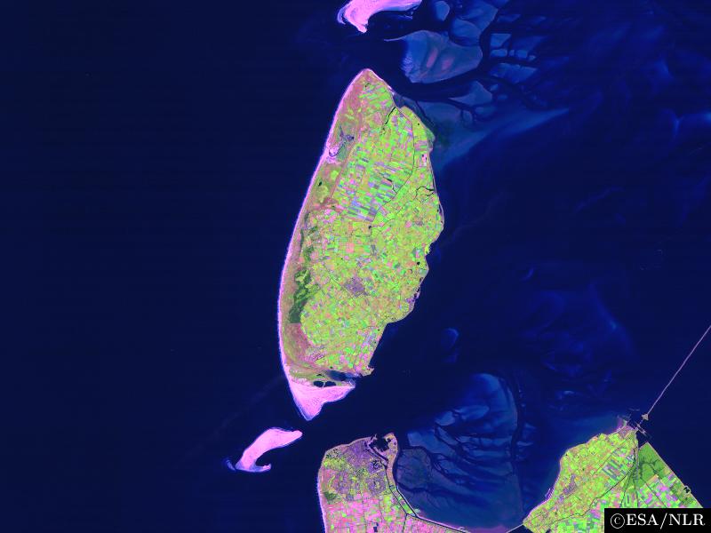
en:False colour en:satellite en:image of the en:island of en:Texel and its surroundings. The image was made by NLR and ESA.NLR and ESA are cited as its source. To the south of the island, part of the en:mainland of the Dutch en:province of en:North Holland can be seen, including the en:city of en:Den Helder (bottom center) and the former island of en:Wieringen (bottom right). Further features include the sand bar of en:Noorderhaaks to the southwest of Texel; the southernmost part of the neighbouring island of en:Vlieland (top center); the en:Afsluitdijk en:dam, which connects North Holland to en:Friesland (center right), the en:Wadden Sea, east of Texel; and the en:North Sea (west of Texel). |
| Dagsetning | 23. ágúst 2004 (original upload date) |
| Uppruni | Transferred from en.wikipedia to Commons. |
| Höfundarréttarhafi | The original uploader was Cwoyte at enska Wikipedia. |
Leyfisupplýsingar:

|
The copyright holder of this file allows anyone to use it for any purpose, provided that the copyright holder is properly attributed. Redistribution, derivative work, commercial use, and all other use is permitted. |
|
|
Original upload log
The original description page was here. All following user names refer to en.wikipedia.
- 2004-08-23 09:49 Cwoyte 800×600×8 (45082 bytes) Satellite image of the island of Texel and its surroundings.
Breytingaskrá skjals
Smelltu á dagsetningu eða tímasetningu til að sjá hvernig hún leit þá út.
| Dagsetning/Tími | Smámynd | Víddir | Notandi | Athugasemd | |
|---|---|---|---|---|---|
| núverandi | 21. maí 2007 kl. 17:53 | | 800 × 600 (44 KB) | Matanya (usurped) | {{Information |Description=en:False colour en:satellite en:image of the en:island of en:Texel and its surroundings. The image was made by [http://www.npoc.nl NLR] and [http://www.esa.int ESA].NLR and ESA are cited as its source. |
Skráartenglar
Eftirfarandi síða notar þessa skrá:
Altæk notkun skráar
Eftirfarandi wikar nota einnig þessa skrá:
- Notkun á br.wikipedia.org
- Notkun á de.wiktionary.org
- Notkun á fa.wikipedia.org
- Notkun á fi.wikipedia.org
- Notkun á he.wikipedia.org
- Notkun á ja.wikipedia.org
- Notkun á ka.wikipedia.org
- Notkun á ko.wikipedia.org
- Notkun á nl.wikipedia.org
- Notkun á th.wikipedia.org
- Notkun á vi.wikipedia.org
- Notkun á www.wikidata.org
- Notkun á zh.wikipedia.org