Mynd:Sweden in 1658.PNG
Það er engin hærri upplausn til.
Sweden_in_1658.PNG (398 × 599 mynddílar, skráarstærð: 63 KB, MIME-gerð: image/png)

|
This map has been uploaded by Electionworld from en.wikipedia.org to enable the |
| Lýsing |
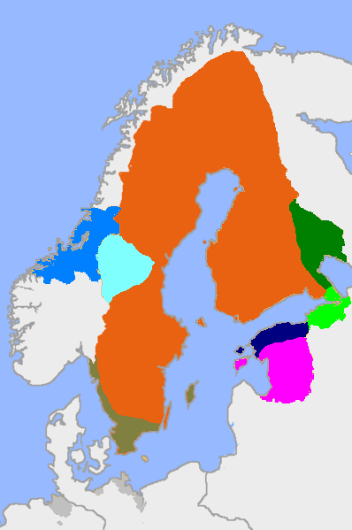
English: Sweden in 1658. The actual main part of the realm and the dominions in different colours.
Key
Svenska: Sverige 1658.
Färger
Suomi: Ruotsin valtakunta vuonna 1658
Värit
Eesti: Rootsi 1658. Värvid
|
||||||||
| Dagsetning | |||||||||
| Uppruni | On the basis of former file version, using Image:Sweden_1658.jpg and Image:Historical provinces of sweden no national borders.png for help. This version differentiates between the actual main realm and does not have interference from contemporary borders. | ||||||||
| Höfundarréttarhafi | User:MPorciusCato, Litany | ||||||||
| Réttindi (Endurnotkun á þessari skrá) |
I, the copyright holder of this work, hereby publish it under the following licenses:
Þú mátt velja notkunarleyfi að eigin vali. |


|
This historical map image could be re-created using vector graphics as an SVG file. This has several advantages; see Commons:Media for cleanup for more information. If an SVG form of this image is available, please upload it and afterwards replace this template with
{{vector version available|new image name}}.
It is recommended to name the SVG file “Sweden in 1658.svg”—then the template Vector version available (or Vva) does not need the new image name parameter. |
Breytingaskrá skjals
Smelltu á dagsetningu eða tímasetningu til að sjá hvernig hún leit þá út.
| Dagsetning/Tími | Smámynd | Víddir | Notandi | Athugasemd | |
|---|---|---|---|---|---|
| núverandi | 26. september 2007 kl. 17:15 | | 398 × 599 (63 KB) | MPorciusCato | {{Information |Description={{en|Sweden in 1658. The actual main part of the realm and the dominions in different colours <br> '''Key''' *Red: main part of the realm *Dark green: Kexholm County. *Light green: [[:en:Ingermanland|Inge |
| 21. febrúar 2007 kl. 19:56 |  | 398 × 599 (66 KB) | Tene~commonswiki | Optimised (0;4192) | |
| 29. desember 2006 kl. 15:53 |  | 398 × 599 (78 KB) | Electionworld | {{ew|en|Litany}} == Summary == slightly modified map from http://en.wikipedia.org/wiki/Image:Sweden_1658.png, with extended german territories == Licensing == {{GFDL-self}} |
Skráartenglar
Eftirfarandi síða notar þessa skrá:
Altæk notkun skráar
Eftirfarandi wikar nota einnig þessa skrá:
- Notkun á ar.wikipedia.org
- Notkun á ast.wikipedia.org
- Notkun á ba.wikipedia.org
- Notkun á be-tarask.wikipedia.org
- Notkun á be.wikipedia.org
- Notkun á bg.wikipedia.org
- Notkun á br.wikipedia.org
- Notkun á ca.wikipedia.org
- Notkun á cs.wikipedia.org
- Notkun á da.wikipedia.org
- Notkun á et.wikipedia.org
- Notkun á fi.wikipedia.org
- Notkun á fr.wikipedia.org
- Notkun á he.wikipedia.org
- Notkun á hr.wikipedia.org
- Notkun á it.wikipedia.org
- Notkun á krc.wikipedia.org
- Notkun á lv.wikipedia.org
- Notkun á mk.wikipedia.org
- Notkun á nl.wikipedia.org
- Notkun á pl.wikipedia.org
Skoða frekari altæka notkun þessarar skráar.