Mynd:Quebec province topographic map-fr.svg

Stærð þessarar PNG forskoðunar á SVG skránni: 484 × 600 mynddílar. Aðrar upplausnir: 194 × 240 mynddílar | 387 × 480 mynddílar | 620 × 768 mynddílar | 826 × 1.024 mynddílar | 1.652 × 2.048 mynddílar | 1.261 × 1.563 mynddílar.
Upphafleg skrá (SVG-skrá, að nafni til 1.261 × 1.563 mynddílar, skráarstærð: 956 KB)
This image was selected as picture of the day on Wikimedia Commons for 25 November 2009. It was captioned as follows: Other languages:
Bosanski: Topografska mapa Kvebeka (Kanada) na francuskom sa gradovima iz popisa 2000. Français : Carte topographique en français du Québec, Canada, avec agglomérations suivant le recensement de 2000. Italiano: Carta topografica in francese della provincia canadese del Québec aggiornata secondo i dati del censimento del 2000. Magyar: A kanadai Québec tartomány francia nyelvű topográfiai térképe a 2000-es népszámlálás szerinti városok feltüntetésével Nederlands: Franstalige topografische kaart van de Canadese (Franssprekende) provincie Québec met de steden van de volkstelling van 2002 Polski: Topograficzna mapa Quebecu (Kanada) w języku francuskim. Português: Mapa topográfico em francês do Quebeque, Canadá, com as cidades do censo de 2000. Македонски: Топографска карта на покраината Квебек, Канада, на француски јазик. Русский: Физическая карта провинции Квебек (Канада) на французском языке. Использованы данные переписи 2000 года. Українська: Фізична карта провінції Квебек, Канада французькою мовою. Наведені дані перепису населення 2000 року. বাংলা : ফরাসী ভাষায় লিখিত কানাডার, কুইবেক অঙ্গরাজ্যের প্রাকৃতিক মানচিত্র। প্রায় ২০০০ শহর উল্লেখিত রয়েছে। 中文: 加拿大魁北克地形学法文地图,根据2000年城市人口普查数据绘制 中文(繁體): 加拿大魁北克地形學法文地圖,根據2000年城市人口普查數據繪製 |
|

Lýsing
| Camera location | | View this and other nearby images on: OpenStreetMap |
|---|
| Lýsing |
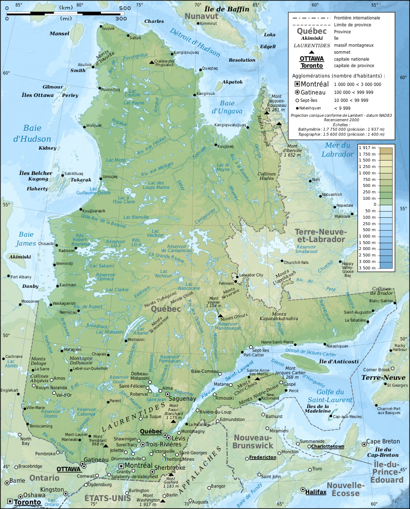
English: Topographic map in French of Quebec, Canada, with 2000' census cities. Note: The background map is a raster image embedded in the SVG file. Français : Carte topographique en français du Québec, Canada, avec agglomérations suivant le recensement de 2000.
Note : Le fond de carte est une image bitmap embarquée dans le fichier SVG.
|
||
| Dagsetning | |||
| Uppruni |
Own work ;
|
||
| Höfundarréttarhafi | Eric Gaba (Sting - fr:Sting) | ||
| Réttindi (Endurnotkun á þessari skrá) |
|
||
| Aðrar útgáfur |
[]
Same base map but with topography and without transportation:
Same map, but with an extra layer containing locations of Hydro-Québec's generating stations and 735 kV lines and substations
|


|
This SVG file contains embedded text that can be translated into your language, using any capable SVG editor, text editor or the SVG Translate tool. For more information see: About translating SVG files. |
Leyfisupplýsingar:
I, the copyright holder of this work, hereby publish it under the following licenses:

|
Gefið er leyfi til að afrita, dreifa og/eða breyta þessu skjali samkvæmt Frjálsa GNU Free Documentation License, útgáfu 1.2 eða nýrri, sem gefið er út af Frjálsu hugbúnaðarstofnuninni með engum breytingum þar á. Afrit af leyfinu er innifalið í kaflanum GNU Free Documentation License. |
This file is licensed under the Creative Commons Attribution-Share Alike 4.0 International, 3.0 Unported, 2.5 Generic, 2.0 Generic and 1.0 Generic license.
- Þér er frjálst:
- að deila – að afrita, deila og yfirfæra verkið
- að blanda – að breyta verkinu
- Undir eftirfarandi skilmálum:
- tilvísun höfundarréttar – Þú verður að tilgreina viðurkenningu á höfundarréttindum, gefa upp tengil á notkunarleyfið og gefa til kynna ef breytingar hafa verið gerðar. Þú getur gert þetta á einhvern ásættanlegan máta, en ekki á nokkurn þann hátt sem bendi til þess að leyfisveitandinn styðji þig eða notkun þína á verkinu.
- Deila eins – Ef þú breytir, yfirfærir eða byggir á þessu efni, þá mátt þú eingöngu dreifa því verki með sama eða svipuðu leyfi og upprunalega verkið er með.
Þú mátt velja notkunarleyfi að eigin vali.
Breytingaskrá skjals
Smelltu á dagsetningu eða tímasetningu til að sjá hvernig hún leit þá út.
| Dagsetning/Tími | Smámynd | Víddir | Notandi | Athugasemd | |
|---|---|---|---|---|---|
| núverandi | 3. mars 2009 kl. 13:43 | | 1.261 × 1.563 (956 KB) | Sting | Correction ; + additional labels |
| 3. mars 2009 kl. 00:04 |  | 1.261 × 1.563 (949 KB) | Sting | == Summary == {{Location|54|00|00|N|68|30|00|W|scale:10000000}} <br/> {{Information |Description={{en|Topographic map in French of Quebec, Canada, with 2000' census cities.}} {{fr|Carte topographique en français du [[:fr:Qu� |
Skráartenglar
Eftirfarandi síða notar þessa skrá:
Altæk notkun skráar
Eftirfarandi wikar nota einnig þessa skrá:
- Notkun á af.wikipedia.org
- Notkun á ba.wikipedia.org
- Notkun á bn.wikipedia.org
- Notkun á crh.wikipedia.org
- Notkun á cs.wikipedia.org
- Notkun á cv.wikipedia.org
- Notkun á da.wikipedia.org
- Notkun á en.wikipedia.org
- Notkun á et.wikipedia.org
- Notkun á frp.wikipedia.org
- Notkun á fr.wikipedia.org
- Géographie du Québec
- Utilisateur:Sting
- Québec
- Araignées du Québec
- Wikipédia:Image du jour/mars 2009
- Projet:Cartographie/Cartes standards/Pays
- Wikipédia:Atelier graphique/Cartes/Archives/mars 2009
- Wikipédia:Image du jour/29 mars 2009
- Wikipédia:Atelier graphique/Cartes/Archives/juin 2009
- Wikipédia:Atelier graphique/Cartes/Archives/avril 2010
- Wikipédia:Atelier graphique/Cartes/Archives/Demandes mises en sommeil/Europe
- Notkun á hu.wikipedia.org
- Notkun á ko.wikipedia.org
- Notkun á krc.wikipedia.org
- Notkun á lbe.wikipedia.org
- Notkun á lmo.wikipedia.org
- Notkun á mk.wikipedia.org
- Notkun á nl.wikipedia.org
- Notkun á oc.wikipedia.org
- Notkun á os.wikipedia.org
- Notkun á pam.wikipedia.org
- Notkun á pl.wikipedia.org
- Notkun á pt.wikipedia.org
- Notkun á ru.wikipedia.org
- Notkun á ru.wikinews.org
- Notkun á sah.wikipedia.org
- Notkun á sn.wikipedia.org
- Notkun á sv.wikipedia.org
- Notkun á uk.wikipedia.org
Skoða frekari altæka notkun þessarar skráar.