Mynd:Percentage population undernourished world map.PNG

Stærð þessarar forskoðunar: 800 × 362 mynddílar Aðrar upplausnir: 320 × 145 mynddílar | 640 × 289 mynddílar | 1.237 × 559 mynddílar.
Upphafleg skrá (1.237 × 559 mynddílar, skráarstærð: 161 KB, MIME-gerð: image/png)
Lýsing
| Lýsing |
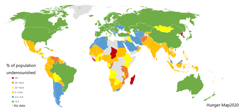
English: List of countries by percentage of population suffering from undernourishment. Made by jp:User:Fnweirkmnwperojvnu, using Map of Excel. The map has been updated (on 2021-01-11) according to the "Hunger Map 2020" from the United Nations World Food Programme.
Sources: Sustainable Development Goal indicators website "Global SDG Indicators Database>GOLE2 End hunger, achieve food security and improved nutrition and promote sustainable agriculture": https://unstats.un.org/sdgs/indicators/database/?indicator=2.1.1 United Nations World Food Programme's interactive "hunger map": http://cdn.wfp.org/hungermap/ Hunger Map 2020: https://www.wfp.org/publications/hunger-map-2020 |
| Dagsetning | 11. janúar 2021 (original upload date) |
| Uppruni | Transferred from en.wikipedia to Commons. |
| Höfundarréttarhafi | The original uploader was Fnweirkmnwperojvnu at jp Wikipedia. |
| Aðrar útgáfur |
Derivative works of this file: Percentage population undernourished world map-ar.PNG  |


|
This map image could be re-created using vector graphics as an SVG file. This has several advantages; see Commons:Media for cleanup for more information. If an SVG form of this image is available, please upload it and afterwards replace this template with
{{vector version available|new image name}}.
It is recommended to name the SVG file “Percentage population undernourished world map.svg”—then the template Vector version available (or Vva) does not need the new image name parameter. |
Leyfisupplýsingar:

|
Gefið er leyfi til að afrita, dreifa og/eða breyta þessu skjali samkvæmt Frjálsa GNU Free Documentation License, útgáfu 1.2 eða nýrri, sem gefið er út af Frjálsu hugbúnaðarstofnuninni með engum breytingum þar á. Afrit af leyfinu er innifalið í kaflanum GNU Free Documentation License. |
| Þessi skrá er með Creative Commons Tilvísun-DeilaEins 3.0 Óstaðfært notkunarleyfi. | ||
| ||
| This licensing tag was added to this file as part of the GFDL licensing update. |
Original upload log
The original description page was here. All following user names refer to en.wikipedia.
- 2007-03-23 02:31 Lobizón 1355×768×8 (58226 bytes) List of countries by percentage of population suffering from undernourishment. Made from Wikipedia's "map of the world" template, using information from the United Nations World Food Programme and the FAO "The State of Food Insecurity in the World 2006" r
Breytingaskrá skjals
Smelltu á dagsetningu eða tímasetningu til að sjá hvernig hún leit þá út.
| Dagsetning/Tími | Smámynd | Víddir | Notandi | Athugasemd | |
|---|---|---|---|---|---|
| núverandi | 10. janúar 2021 kl. 16:31 | | 1.237 × 559 (161 KB) | Fnweirkmnwperojvnu | data updates |
| 18. júlí 2020 kl. 21:07 |  | 1.357 × 628 (47 KB) | Maphobbyist | South Sudan border | |
| 16. apríl 2016 kl. 18:30 |  | 1.357 × 628 (46 KB) | Kontrollstellekundl | updated according to the "Hunger Map 2013" http://documents.wfp.org/stellent/groups/public/documents/communications/wfp229327.pdf | |
| 28. febrúar 2016 kl. 12:20 |  | 1.357 × 628 (45 KB) | Kontrollstellekundl | cropped | |
| 15. ágúst 2015 kl. 14:08 |  | 1.355 × 768 (46 KB) | Jamie Tubers | update | |
| 31. desember 2013 kl. 04:38 |  | 1.355 × 768 (56 KB) | Varitia | Small correction on Indonesia | |
| 31. desember 2013 kl. 04:19 |  | 1.355 × 768 (56 KB) | Varitia | Update to 2012 figures and parameters according to the United Nations World Food Programme | |
| 4. maí 2008 kl. 23:04 |  | 1.355 × 768 (56 KB) | Dwrcan | Updates. (Note: click on the actual countries of the source map, the actual data sometimes doesn't match the color of the country.) | |
| 10. nóvember 2007 kl. 21:00 |  | 1.355 × 768 (57 KB) | Béka~commonswiki | {{Information |Description={{en|List of countries by percentile of population suffering from undernourishment. Made by en:User:Lobizón, using Wikipedia's "map of the world" template, and information from the United Nations World Food Programme and t |
Skráartenglar
Eftirfarandi 2 síður nota þessa skrá:
Altæk notkun skráar
Eftirfarandi wikar nota einnig þessa skrá:
- Notkun á af.wikipedia.org
- Notkun á ast.wikipedia.org
- Notkun á ba.wikipedia.org
- Notkun á bg.wikipedia.org
- Notkun á bn.wikipedia.org
- Notkun á cs.wikipedia.org
- Notkun á cv.wikipedia.org
- Notkun á de.wikipedia.org
- Notkun á en.wikipedia.org
- Notkun á en.wikinews.org
- Notkun á eo.wikipedia.org
- Notkun á es.wikipedia.org
- Notkun á es.wikinews.org
- Notkun á eu.wikipedia.org
- Notkun á fa.wikipedia.org
- Notkun á fi.wikipedia.org
- Notkun á fy.wikipedia.org
- Notkun á gu.wikipedia.org
- Notkun á he.wikipedia.org
- Notkun á hr.wikipedia.org
- Notkun á hu.wikipedia.org
- Notkun á hy.wikipedia.org
- Notkun á id.wikipedia.org
- Notkun á it.wikipedia.org
- Notkun á ja.wikipedia.org
- Notkun á kn.wikipedia.org
- Notkun á la.wikipedia.org
- Notkun á lmo.wikipedia.org
- Notkun á lt.wikipedia.org
- Notkun á lv.wikipedia.org
- Notkun á mk.wikipedia.org
Skoða frekari altæka notkun þessarar skráar.