Mynd:Octodon degus range map.png
Það er engin hærri upplausn til.
Octodon_degus_range_map.png (218 × 336 mynddílar, skráarstærð: 5 KB, MIME-gerð: image/png)
Lýsing
| Lýsing |
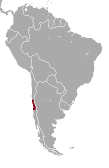
English: Octodon degus range map
Source - http://maps.iucnredlist.org/map.html?id=15088
Български: Ареал на разпространение на Дегу |
| Uppruni | eigin skrá |
| Höfundarréttarhafi | Izvora |
Leyfisupplýsingar:
I, the copyright holder of this work, hereby publish it under the following license:
| This file is made available under the Creative Commons CC0 1.0 Universal Public Domain Dedication. | |
| The person who associated a work with this deed has dedicated the work to the public domain by waiving all of their rights to the work worldwide under copyright law, including all related and neighboring rights, to the extent allowed by law. You can copy, modify, distribute and perform the work, even for commercial purposes, all without asking permission.
|
Breytingaskrá skjals
Smelltu á dagsetningu eða tímasetningu til að sjá hvernig hún leit þá út.
| Dagsetning/Tími | Smámynd | Víddir | Notandi | Athugasemd | |
|---|---|---|---|---|---|
| núverandi | 13. desember 2012 kl. 19:40 | | 218 × 336 (5 KB) | Izvora | {{Information |Description ={{en|1=Octodon degus range map Source - http://maps.iucnredlist.org/map.html?id=15088}} {{bg|1=Ареал на разпространение на Дегу}} |Source ={{own}} |Author =[[User:Izvora|Izvora]... |
Skráartenglar
Eftirfarandi síða notar þessa skrá:
Altæk notkun skráar
Eftirfarandi wikar nota einnig þessa skrá:
- Notkun á arz.wikipedia.org
- Notkun á ast.wikipedia.org
- Notkun á bg.wikipedia.org
- Notkun á ca.wikipedia.org
- Notkun á cs.wikipedia.org
- Notkun á eu.wikipedia.org
- Notkun á fr.wikipedia.org
- Notkun á pt.wikipedia.org
- Notkun á vi.wikipedia.org
- Notkun á www.wikidata.org