Mynd:North ossetia alania map.png

Stærð þessarar forskoðunar: 534 × 599 mynddílar Aðrar upplausnir: 214 × 240 mynddílar | 428 × 480 mynddílar | 720 × 808 mynddílar.
Upphafleg skrá (720 × 808 mynddílar, skráarstærð: 53 KB, MIME-gerð: image/png)
Lýsing
| Lýsing |
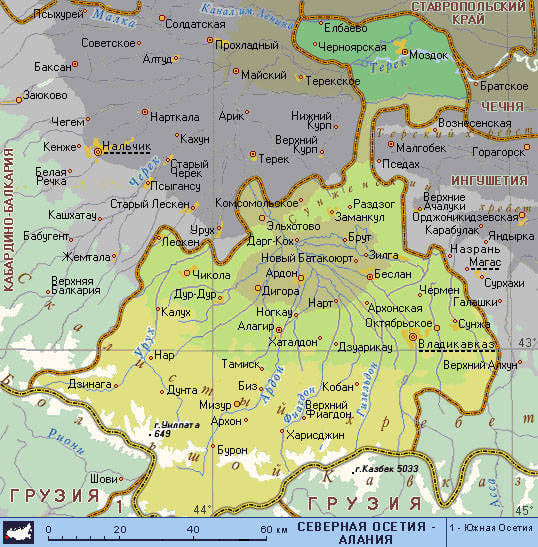
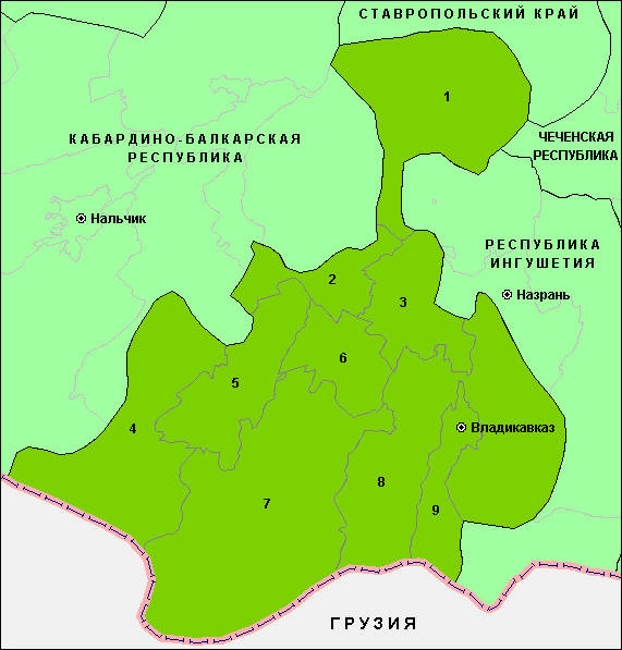
English: Map of the Republic of North Ossetia-Alania. |
| Dagsetning | |
| Uppruni | eigin skrá |
| Höfundarréttarhafi | PANONIAN |
Leyfisupplýsingar:
I, the copyright holder of this work, hereby publish it under the following license:
| This file is made available under the Creative Commons CC0 1.0 Universal Public Domain Dedication. | |
| The person who associated a work with this deed has dedicated the work to the public domain by waiving all of their rights to the work worldwide under copyright law, including all related and neighboring rights, to the extent allowed by law. You can copy, modify, distribute and perform the work, even for commercial purposes, all without asking permission.
|
References
Maps from external links:
- http://www.skppk.ru/i/map/osetiya_region_map.jpg
- http://ossetians.com/pictures/Map_1.jpg
- http://topwar.ru/uploads/posts/2011-06/1309189225_alania_karta.jpg
- http://www.stopwatchhut.com/places/770.jpg
- http://nocss.ru/projects/10/images/map-1.jpg
- http://karty.narod.ru/maps/sosetia/s-osetia.GIF
- http://obkom.com/russia/fussr/osetiya-yuzhnaya/images/karta-osetia-sev-yuzh.jpg
- http://karta-russia.ru/maps/map-severnaya-osetiya-karta.jpg
- http://alcoinf.com/images/severnaya-osetiya.gif
- http://sif.ru/images/maps/Severnaya-Osetiya2.gif
- http://region15.ru/img/territor/map-adm.gif
- http://www.hge.pu.ru/mapgis/subekt/osetia/osetia.gif
- http://www.smsr-senclub.ru/upload/medialibrary/ece/ece341c19c79030e09063fff6763d2d5.jpg
- http://www.rossadovod.ru/regions/osetia-alania/map.jpg
- http://www.ntsomz.ru/img/severnaya%20osetiya_800x566.jpg
- http://trasa.ru/img/regions/sevosetiya.gif
- http://dic.academic.ru/pictures/enc_geo/Severnaya_Osetia-Alania.jpg
- http://geo.1september.ru/2008/22/40-1.jpg
- http://openbudget.karelia.ru/budnord/russian/north-caucasian/northern-ossetiya-republic/images/karta_alania.jpg
List of largest cities and towns:
Breytingaskrá skjals
Smelltu á dagsetningu eða tímasetningu til að sjá hvernig hún leit þá út.
| Dagsetning/Tími | Smámynd | Víddir | Notandi | Athugasemd | |
|---|---|---|---|---|---|
| núverandi | 17. júní 2012 kl. 06:51 | | 720 × 808 (53 KB) | PANONIAN | {{Information |Description ={{en|1=Map of the Republic of North Ossetia-Alania.}} |Source ={{own}} |Author =PANONIAN |Date =2012 |Permission = |other_versions = }} |
Skráartenglar
Eftirfarandi síða notar þessa skrá:
Altæk notkun skráar
Eftirfarandi wikar nota einnig þessa skrá:
- Notkun á ace.wikipedia.org
- Notkun á ast.wikipedia.org
- Notkun á az.wikipedia.org
- Notkun á ba.wikipedia.org
- Notkun á be-tarask.wikipedia.org
- Notkun á be.wikipedia.org
- Notkun á bg.wikipedia.org
- Notkun á br.wikipedia.org
- Notkun á bs.wikipedia.org
- Notkun á bxr.wikipedia.org
- Notkun á ce.wikipedia.org
- Notkun á cs.wikipedia.org
- Notkun á cv.wikipedia.org
- Notkun á diq.wikipedia.org
- Notkun á en.wikipedia.org
- Notkun á es.wikipedia.org
- Notkun á et.wikipedia.org
- Notkun á eu.wikipedia.org
- Notkun á fo.wikipedia.org
- Notkun á ga.wikipedia.org
- Notkun á gl.wikipedia.org
- Notkun á got.wikipedia.org
- Notkun á hy.wikipedia.org
- Notkun á id.wikipedia.org
- Notkun á it.wikipedia.org
- Notkun á ka.wikipedia.org
- Notkun á kbd.wikipedia.org
- Notkun á koi.wikipedia.org
- Notkun á krc.wikipedia.org
- Notkun á kv.wikipedia.org
- Notkun á la.wikipedia.org
- Notkun á lbe.wikipedia.org
- Notkun á lmo.wikipedia.org
- Notkun á lt.wikipedia.org
- Notkun á mhr.wikipedia.org
- Notkun á mn.wikipedia.org
- Notkun á mr.wikipedia.org
- Notkun á ms.wikipedia.org
- Notkun á myv.wikipedia.org
- Notkun á nn.wikipedia.org
- Notkun á pnb.wikipedia.org
- Notkun á ps.wikipedia.org
- Notkun á ro.wikipedia.org
- Notkun á rw.wikipedia.org
- Notkun á sah.wikipedia.org
- Notkun á scn.wikipedia.org
- Notkun á sco.wikipedia.org
- Notkun á se.wikipedia.org
- Notkun á simple.wikipedia.org
Skoða frekari altæka notkun þessarar skráar.