Mynd:North German Confederation 1870.svg

Stærð þessarar PNG forskoðunar á SVG skránni: 450 × 456 mynddílar. Aðrar upplausnir: 237 × 240 mynddílar | 474 × 480 mynddílar | 758 × 768 mynddílar | 1.011 × 1.024 mynddílar | 2.021 × 2.048 mynddílar.
Upphafleg skrá (SVG-skrá, að nafni til 450 × 456 mynddílar, skráarstærð: 705 KB)
Lýsing
This W3C-unspecified vector image was created with Inkscape .


.svg)
.svg)
.svg)
.svg)
.svg)


.svg)
.svg)
.svg)


.png)
.png)


.svg)


.svg)

.svg)


.svg)
.svg)
.svg)
.svg)


.svg)
.png)


.svg)


.svg)
.svg)


.svg)


.svg)


.svg)
.svg)
.svg)
.svg)
.svg)
.svg)
.svg)
_cropped.svg)
.svg)
.svg)
.svg)
.svg)
.svg)
.svg)
.svg)
.svg)
.svg)
.svg)
.svg)
.svg)
.svg)
.svg)
.svg)
.svg)
.svg)
.svg)
.svg)
.svg)
.svg)
.svg)
.svg)
.svg)
.svg)
.svg)
.svg)
.svg)
.svg)
.svg)
.svg)
.svg)
.svg)
.svg)
.svg)
.svg)
.svg)
.svg)
.svg)
.svg)
.svg)
.svg)
.svg)
.svg)
.svg)
Leyfisupplýsingar:
This file is licensed under the Creative Commons Attribution-Share Alike 4.0 International license.
- Þér er frjálst:
- að deila – að afrita, deila og yfirfæra verkið
- að blanda – að breyta verkinu
- Undir eftirfarandi skilmálum:
- tilvísun höfundarréttar – Þú verður að tilgreina viðurkenningu á höfundarréttindum, gefa upp tengil á notkunarleyfið og gefa til kynna ef breytingar hafa verið gerðar. Þú getur gert þetta á einhvern ásættanlegan máta, en ekki á nokkurn þann hátt sem bendi til þess að leyfisveitandinn styðji þig eða notkun þína á verkinu.
- Deila eins – Ef þú breytir, yfirfærir eða byggir á þessu efni, þá mátt þú eingöngu dreifa því verki með sama eða svipuðu leyfi og upprunalega verkið er með.
Breytingaskrá skjals
Smelltu á dagsetningu eða tímasetningu til að sjá hvernig hún leit þá út.
| Dagsetning/Tími | Smámynd | Víddir | Notandi | Athugasemd | |
|---|---|---|---|---|---|
| núverandi | 1. júní 2016 kl. 02:58 | | 450 × 456 (705 KB) | Alphathon | Various corrections to the states of the North German Confederation |
| 31. maí 2016 kl. 05:22 |  | 450 × 456 (662 KB) | Alphathon | Uploaded wrong file | |
| 31. maí 2016 kl. 05:22 |  | 450 × 456 (725 KB) | Alphathon | Minor corrections (Tarasp and post-1818 German Confederation border change) | |
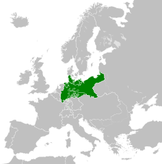
| 31. maí 2016 kl. 02:40 |  | 450 × 456 (662 KB) | Alphathon | == {{int:filedesc}} == {{Inkscape}} {{Information |Description={{en|A map of the en:North German Confederation within Europe circa 1870 CE.}} |Source= {{Derived from|Blank_map_of_Europe.svg|display=50}} |Date=2016-05-31 |Author=*[[:File:Bla... |
Skráartenglar
Eftirfarandi síða notar þessa skrá:
Altæk notkun skráar
Eftirfarandi wikar nota einnig þessa skrá:
- Notkun á ang.wikipedia.org
- Notkun á ar.wikipedia.org
- Notkun á azb.wikipedia.org
- Notkun á bg.wikipedia.org
- Notkun á cs.wikipedia.org
- Notkun á en.wikipedia.org
- Notkun á es.wikipedia.org
- Notkun á eu.wikipedia.org
- Notkun á fa.wikipedia.org
- Notkun á fi.wikipedia.org
- Notkun á fr.wikipedia.org
- Notkun á he.wikipedia.org
- Notkun á hr.wikipedia.org
- Notkun á it.wikipedia.org
- Notkun á ko.wikipedia.org
- Notkun á lt.wikipedia.org
- Notkun á lv.wikipedia.org
- Notkun á ms.wikipedia.org
- Notkun á pl.wikipedia.org
- Notkun á pt.wikipedia.org
- Notkun á ru.wikipedia.org
- Notkun á sv.wikipedia.org
- Notkun á th.wikipedia.org
- Notkun á tr.wikipedia.org
- Notkun á vi.wikipedia.org
- Notkun á zh.wikipedia.org