Mynd:Near east lrg.jpg

Upphafleg skrá (2.987 × 3.967 mynddílar, skráarstærð: 2,62 MB, MIME-gerð: image/jpeg)
| Lýsing |
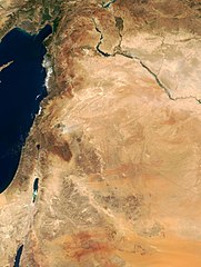
This true-color image of the region was taken on September 10, 2000, by the MODerate-resolution Imaging Spectroradiometer (MODIS) flying aboard NASA's Terra spacecraft. The image shows the lands of Israel along the eastern shore of the Mediterranean Sea, with the countries of Jordan to the southeast and Syria to the Northeast. The region known as the West Bank lies between the two countries. Running from north to south, the Jordan River links the Sea of Galilee to the Dead Sea. Click the image to enlarge it, and to see the borders drawn in. Image courtesy Jacques Descloitres, MODIS Land Group, NASA GSFC |
| Dagsetning | image taken on 10. Sep. 2000 |
| Uppruni | http://earthobservatory.nasa.gov/Newsroom/NewImages/Images/modis_near_east_lrg.jpg |
| Höfundarréttarhafi | NASA, earthobservatory, http://earthobservatory.nasa.gov/ |
| Réttindi (Endurnotkun á þessari skrá) |
PD-USGov-NASA |
| This file is in the public domain in the United States because it was solely created by NASA. NASA copyright policy states that "NASA material is not protected by copyright unless noted". (See Template:PD-USGov, NASA copyright policy page or JPL Image Use Policy.) | ||
 |
Warnings:
|
Breytingaskrá skjals
Smelltu á dagsetningu eða tímasetningu til að sjá hvernig hún leit þá út.
| Dagsetning/Tími | Smámynd | Víddir | Notandi | Athugasemd | |
|---|---|---|---|---|---|
| núverandi | 5. febrúar 2015 kl. 20:27 | | 2.987 × 3.967 (2,62 MB) | Capricorn4049 | Cropped < 1 % horizontally and 1 % vertically using CropTool with precise mode. |
| 5. júní 2005 kl. 09:29 |  | 3.002 × 4.002 (1,96 MB) | Prolineserver | near east, PD-USGov-NASA |
Skráartenglar
Eftirfarandi síða notar þessa skrá:
Altæk notkun skráar
Eftirfarandi wikar nota einnig þessa skrá:
- Notkun á ar.wikipedia.org
- Notkun á arz.wikipedia.org
- Notkun á ast.wikipedia.org
- Notkun á ba.wikipedia.org
- Notkun á ca.wikipedia.org
- Notkun á ckb.wikipedia.org
- Notkun á el.wikipedia.org
- Notkun á en.wikipedia.org
- Notkun á eo.wikipedia.org
- Notkun á eo.wikiquote.org
- Notkun á es.wikipedia.org
- Notkun á eu.wikipedia.org
- Notkun á fa.wikipedia.org
- Notkun á fr.wikipedia.org
- Notkun á gl.wikipedia.org
- Notkun á he.wikipedia.org
- Notkun á id.wikipedia.org
- Notkun á it.wikipedia.org
- Notkun á ja.wikipedia.org
- Notkun á kbp.wikipedia.org
- Notkun á ko.wikipedia.org
- Notkun á mk.wikipedia.org
Skoða frekari altæka notkun þessarar skráar.