Mynd:Montana Relief 1.jpg
Það er engin hærri upplausn til.
Montana_Relief_1.jpg (500 × 345 mynddílar, skráarstærð: 70 KB, MIME-gerð: image/jpeg)
Lýsing
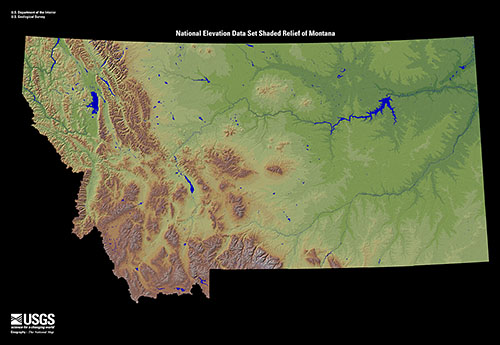
| Lýsing |
English: Shaded relief map of the U.S. state of Montana. From the United States Geological Survey. |
| Dagsetning | |
| Uppruni | EROS USGS |
| Höfundarréttarhafi | United States Geological Survey |
Leyfisupplýsingar:
This image is in the public domain in the United States because it only contains materials that originally came from the United States Geological Survey, an agency of the United States Department of the Interior. For more information, see the official USGS copyright policy.
|
Breytingaskrá skjals
Smelltu á dagsetningu eða tímasetningu til að sjá hvernig hún leit þá út.
| Dagsetning/Tími | Smámynd | Víddir | Notandi | Athugasemd | |
|---|---|---|---|---|---|
| núverandi | 23. nóvember 2008 kl. 19:31 | | 500 × 345 (70 KB) | AlexiusHoratius~commonswiki | {{Information |Description={{en|1=Shaded relief map of the U.S. state of Montana. From the United States Geological Survey.}} |Source=http://eros.usgs.gov/imagegallery/index.php/collection/ned_states |Author=United States Geological Survey |Date= |Permiss |
Skráartenglar
Eftirfarandi síða notar þessa skrá:
Altæk notkun skráar
Eftirfarandi wikar nota einnig þessa skrá:
- Notkun á bg.wikipedia.org
- Notkun á el.wikipedia.org
- Notkun á en.wikipedia.org
- Notkun á fy.wikipedia.org
- Notkun á ja.wikipedia.org
- Notkun á pam.wikipedia.org
- Notkun á sah.wikipedia.org
- Notkun á zh.wikipedia.org