Mynd:Middle East (historical definition)(orthographic projection).svg

Stærð þessarar PNG forskoðunar á SVG skránni: 553 × 553 mynddílar. Aðrar upplausnir: 240 × 240 mynddílar | 480 × 480 mynddílar | 768 × 768 mynddílar | 1.024 × 1.024 mynddílar | 2.048 × 2.048 mynddílar.
Upphafleg skrá (SVG-skrá, að nafni til 553 × 553 mynddílar, skráarstærð: 408 KB)
(orthographic_projection).svg)
Lýsing
| Lýsing |
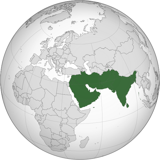
English: Orthographic grey-and-green locator map of the Middle East's historical definition as the Asian lands and islands to the west of the "Far East", with 21st-century international borders.
The Indian subcontinent here is the eastern extreme of the Middle East, with Burma counted as the "Far East". Sinai, Egypt, and Africa as a whole are here excluded, as are modern Turkey and the countries of the Caucasus. Afghanistan is here included, but Turkmenistan and other central Asian countries are excluded. This file was derived from: Middle East (orthographic projection).svg:.svg) |
| Dagsetning | |
| Uppruni | eigin skrá |
| Höfundarréttarhafi | GPinkerton |
Leyfisupplýsingar:
I, the copyright holder of this work, hereby publish it under the following license:
This file is licensed under the Creative Commons Attribution-Share Alike 4.0 International license.
- Þér er frjálst:
- að deila – að afrita, deila og yfirfæra verkið
- að blanda – að breyta verkinu
- Undir eftirfarandi skilmálum:
- tilvísun höfundarréttar – Þú verður að tilgreina viðurkenningu á höfundarréttindum, gefa upp tengil á notkunarleyfið og gefa til kynna ef breytingar hafa verið gerðar. Þú getur gert þetta á einhvern ásættanlegan máta, en ekki á nokkurn þann hátt sem bendi til þess að leyfisveitandinn styðji þig eða notkun þína á verkinu.
- Deila eins – Ef þú breytir, yfirfærir eða byggir á þessu efni, þá mátt þú eingöngu dreifa því verki með sama eða svipuðu leyfi og upprunalega verkið er með.
Breytingaskrá skjals
Smelltu á dagsetningu eða tímasetningu til að sjá hvernig hún leit þá út.
| Dagsetning/Tími | Smámynd | Víddir | Notandi | Athugasemd | |
|---|---|---|---|---|---|
| núverandi | 12. nóvember 2022 kl. 13:40 | | 553 × 553 (408 KB) | GPinkerton | Reverted to version as of 11:38, 1 April 2021 (UTC) Incorrect |
| 12. nóvember 2022 kl. 07:00 |  | 550 × 550 (2,77 MB) | Sourav Bapuli | Excluded India, as historically it was never part of the Middle East. | |
| 1. apríl 2021 kl. 11:38 |  | 553 × 553 (408 KB) | GPinkerton | Uploaded own work with UploadWizard |
Skráartenglar
Það eru engar síður sem nota þessa skrá.
(orthographic_projection).svg)