Mynd:Mauke map.jpg

Stærð þessarar forskoðunar: 800 × 582 mynddílar Aðrar upplausnir: 320 × 233 mynddílar | 640 × 466 mynddílar | 1.024 × 745 mynddílar | 1.240 × 902 mynddílar.
Upphafleg skrá (1.240 × 902 mynddílar, skráarstærð: 130 KB, MIME-gerð: image/jpeg)
Lýsing

|
This map image could be re-created using vector graphics as an SVG file. This has several advantages; see Commons:Media for cleanup for more information. If an SVG form of this image is available, please upload it and afterwards replace this template with
{{vector version available|new image name}}.
It is recommended to name the SVG file “Mauke map.svg”—then the template Vector version available (or Vva) does not need the new image name parameter. |


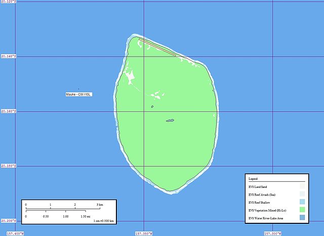
| Lýsing | Map of Mauke (Cook Islands) |
| Dagsetning | |
| Uppruni | Mauke Atoll - Map |
| Höfundarréttarhafi | Mr Minton from San Diego, US |
Leyfisupplýsingar:
This file is licensed under the Creative Commons Attribution 2.0 Generic license.
- Þér er frjálst:
- að deila – að afrita, deila og yfirfæra verkið
- að blanda – að breyta verkinu
- Undir eftirfarandi skilmálum:
- tilvísun höfundarréttar – Þú verður að tilgreina viðurkenningu á höfundarréttindum, gefa upp tengil á notkunarleyfið og gefa til kynna ef breytingar hafa verið gerðar. Þú getur gert þetta á einhvern ásættanlegan máta, en ekki á nokkurn þann hátt sem bendi til þess að leyfisveitandinn styðji þig eða notkun þína á verkinu.
| This image was originally posted to Flickr by EVS-Islands at https://www.flickr.com/photos/60042877@N00/126141302. It was reviewed on 17. ágúst 2007 by FlickreviewR and was confirmed to be licensed under the terms of the cc-by-2.0. |
Breytingaskrá skjals
Smelltu á dagsetningu eða tímasetningu til að sjá hvernig hún leit þá út.
| Dagsetning/Tími | Smámynd | Víddir | Notandi | Athugasemd | |
|---|---|---|---|---|---|
| núverandi | 16. ágúst 2007 kl. 14:20 | | 1.240 × 902 (130 KB) | Henry Merrivale | {{Information |Description= Map of Mauke (Cook Islands) |Source=[http://www.flickr.com/photos/60042877@N00/126141302/ Mauke Atoll - Map] |Date=April 09, 2006 at 20:34 |Author=[http://www.flickr.com/people/60042877@N00 Mr Minton] from San Diego, US |Permis |
Skráartenglar
Eftirfarandi síða notar þessa skrá:
Altæk notkun skráar
Eftirfarandi wikar nota einnig þessa skrá:
- Notkun á ca.wikipedia.org
- Notkun á cs.wikipedia.org
- Notkun á de.wikipedia.org
- Notkun á en.wikipedia.org
- Notkun á en.wikivoyage.org
- Notkun á es.wikipedia.org
- Notkun á fa.wikipedia.org
- Notkun á fr.wikipedia.org
- Notkun á id.wikipedia.org
- Notkun á it.wikipedia.org
- Notkun á ka.wikipedia.org
- Notkun á la.wikipedia.org
- Notkun á lt.wikipedia.org
- Notkun á mt.wikipedia.org
- Notkun á pl.wikipedia.org
- Notkun á su.wikipedia.org
- Notkun á tr.wikipedia.org
- Notkun á uk.wikipedia.org
- Notkun á zh.wikivoyage.org