Mynd:Martinique legende arrs.PNG
Það er engin hærri upplausn til.
Martinique_legende_arrs.PNG (419 × 478 mynddílar, skráarstærð: 16 KB, MIME-gerð: image/png)
Lýsing
| Lýsing |
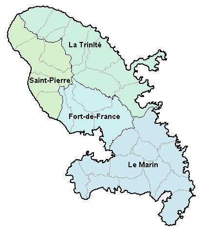
Carte de la Martinique avec ses 4 arrondissements. Map of French department of Martinique with its 4 "arrondissements". |
| Dagsetning | 2. janúar 2007 (original upload date) |
| Uppruni | No machine-readable source provided. Own work assumed (based on copyright claims). |
| Höfundarréttarhafi | No machine-readable author provided. BigonL assumed (based on copyright claims). |
Leyfisupplýsingar:
| I, the copyright holder of this work, release this work into the public domain. This applies worldwide. In some countries this may not be legally possible; if so: I grant anyone the right to use this work for any purpose, without any conditions, unless such conditions are required by law. |
Breytingaskrá skjals
Smelltu á dagsetningu eða tímasetningu til að sjá hvernig hún leit þá út.
| Dagsetning/Tími | Smámynd | Víddir | Notandi | Athugasemd | |
|---|---|---|---|---|---|
| núverandi | 2. janúar 2007 kl. 16:48 | | 419 × 478 (16 KB) | BigonL | Carte de la Martinique avec ses 4 arrondissements. Map of French department of Martinique with its 4 "arrondissements". |
Skráartenglar
Eftirfarandi síða notar þessa skrá:
Altæk notkun skráar
Eftirfarandi wikar nota einnig þessa skrá:
- Notkun á cs.wikipedia.org
- Notkun á cv.wikipedia.org
- Notkun á el.wikipedia.org
- Notkun á en.wikipedia.org
- Notkun á es.wikipedia.org
- Notkun á fa.wikipedia.org
- Notkun á fr.wikipedia.org
- Notkun á gl.wikipedia.org
- Notkun á it.wikipedia.org
- Notkun á ka.wikipedia.org
- Notkun á lb.wikipedia.org
- Notkun á mk.wikipedia.org
- Notkun á oc.wikipedia.org
- Fort-de-France
- Comunas de Martinica
- Modèl:Comunas de Martinica
- L'Ajoupa-Bouillon
- Les Anses-d'Arlet
- Basse-Pointe
- Le Carbet
- Case-Pilote
- Le Diamant
- Ducos
- Fonds-Saint-Denis
- Le François
- Grand'Rivière
- Gros-Morne
- Le Lamentin
- Le Lorrain
- Macouba
- Le Marigot
- Le Marin
- Le Morne-Rouge
- Le Prêcheur
- Rivière-Pilote
- Rivière-Salée
- Le Robert
- Saint-Esprit
- Saint-Joseph (Martinica)
- Saint-Pierre (Martinica)
- Sainte-Luce (Martinica)
- Schœlcher
- La Trinité
- Les Trois-Îlets
- Le Vauclin
- Le Morne-Vert
- Bellefontaine (Martinica)
- Sainte-Marie (Martinica)
- Sainte-Anne (Martinica)
- Notkun á pl.wikipedia.org
Skoða frekari altæka notkun þessarar skráar.