Mynd:Map indicating Davis Strait.png
Það er engin hærri upplausn til.
Map_indicating_Davis_Strait.png (340 × 330 mynddílar, skráarstærð: 47 KB, MIME-gerð: image/png)
Lýsing
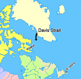
Map indicating Davis Strait, lying between Greenland and Nunavut, Canada.
Nunavut
Quebec
Newfoundland and Labrador
Regions outside Canada (Greenland, Iceland)
© Her Majesty the Queen in Right of Canada, Department of Natural Resources. All rights reserved.
Licence Agreement
Leyfisupplýsingar:

|
The copyright holder of this work allows anyone to use it for any purpose including unrestricted redistribution, commercial use, and modification.
Usage notes:
|
Breytingaskrá skjals
Smelltu á dagsetningu eða tímasetningu til að sjá hvernig hún leit þá út.
| Dagsetning/Tími | Smámynd | Víddir | Notandi | Athugasemd | |
|---|---|---|---|---|---|
| núverandi | 21. mars 2006 kl. 11:08 | | 340 × 330 (47 KB) | David Kernow~commonswiki | Map indicating Davis Strait, lying between Nunavut, Canada and Greenland. {{legend|#ffff66|Nunavut}} {{legend|#d5fe94|Quebec}} {{legend|#ecebb6|Newfoundland and Labrador}} {{legend|#ffffcc|Regions outside Canada (Greenland, Iceland)}} |
Skráartenglar
Eftirfarandi síða notar þessa skrá:
Altæk notkun skráar
Eftirfarandi wikar nota einnig þessa skrá:
- Notkun á be.wikipedia.org
- Notkun á bg.wikipedia.org
- Notkun á bn.wikipedia.org
- Notkun á bs.wikipedia.org
- Notkun á cs.wikipedia.org
- Notkun á da.wikipedia.org
- Notkun á de.wikipedia.org
- Notkun á el.wikipedia.org
- Notkun á en.wikipedia.org
- Notkun á eo.wikipedia.org
- Notkun á fi.wikipedia.org
- Notkun á fy.wikipedia.org
- Notkun á he.wikipedia.org
- Notkun á hr.wikipedia.org
- Notkun á id.wikipedia.org
- Notkun á it.wikipedia.org
- Notkun á ja.wikipedia.org
- Notkun á ko.wikipedia.org
- Notkun á ku.wikipedia.org
- Notkun á la.wikipedia.org
- Notkun á lt.wikipedia.org
- Notkun á ml.wikipedia.org
- Notkun á nn.wikipedia.org
- Notkun á pa.wikipedia.org
- Notkun á pl.wikipedia.org
- Notkun á pnb.wikipedia.org
- Notkun á pt.wikipedia.org
- Notkun á ro.wikipedia.org
- Notkun á sh.wikipedia.org
- Notkun á simple.wikipedia.org
- Notkun á sk.wikipedia.org
- Notkun á sr.wikipedia.org
- Notkun á sv.wikipedia.org
- Notkun á sw.wikipedia.org
- Notkun á th.wikipedia.org
- Notkun á tr.wikipedia.org
- Notkun á uk.wikipedia.org
- Notkun á ur.wikipedia.org
- Notkun á vi.wikipedia.org
- Notkun á war.wikipedia.org
- Notkun á xmf.wikipedia.org
- Notkun á zh-min-nan.wikipedia.org