Mynd:Map Mariana Islands volcanoes.gif

Stærð þessarar forskoðunar: 394 × 599 mynddílar Aðrar upplausnir: 158 × 240 mynddílar | 400 × 608 mynddílar.
Upphafleg skrá (400 × 608 mynddílar, skráarstærð: 19 KB, MIME-gerð: image/gif)
Lýsing
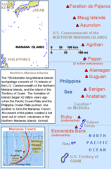
| Lýsing | Map describing volcanoes of the Mariana Islands along the Marianas Trench (east of China and the Philippines). |
| Dagsetning | |
| Uppruni | Derived by cropping US Government (USGS) map: http://vulcan.wr.usgs.gov/Imgs/Gif/MarianaIslands/Maps/map_mariana_islands_volcanoes.gif |
| Höfundarréttarhafi | Wikid77 |
Leyfisupplýsingar:
The map is public domain, derived by User:Wikid77 from a USGS image (in GIF format).
This work is in the public domain in the United States because it is a work prepared by an officer or employee of the United States Government as part of that person’s official duties under the terms of Title 17, Chapter 1, Section 105 of the US Code.
Note: This only applies to original works of the Federal Government and not to the work of any individual U.S. state, territory, commonwealth, county, municipality, or any other subdivision. This template also does not apply to postage stamp designs published by the United States Postal Service since 1978. (See § 313.6(C)(1) of Compendium of U.S. Copyright Office Practices). It also does not apply to certain US coins; see The US Mint Terms of Use.
|
 | |
| This file has been identified as being free of known restrictions under copyright law, including all related and neighboring rights. | ||
Breytingaskrá skjals
Smelltu á dagsetningu eða tímasetningu til að sjá hvernig hún leit þá út.
| Dagsetning/Tími | Smámynd | Víddir | Notandi | Athugasemd | |
|---|---|---|---|---|---|
| núverandi | 29. júní 2010 kl. 19:55 | | 400 × 608 (19 KB) | Ras67 | cropped |
| 7. mars 2008 kl. 14:23 |  | 400 × 640 (21 KB) | Wikid77 | initial upload |
Skráartenglar
Eftirfarandi síða notar þessa skrá:
Altæk notkun skráar
Eftirfarandi wikar nota einnig þessa skrá:
- Notkun á af.wikipedia.org
- Notkun á az.wikipedia.org
- Notkun á br.wikipedia.org
- Notkun á da.wikipedia.org
- Notkun á en.wikipedia.org
- Notkun á fa.wikipedia.org
- Notkun á fi.wikipedia.org
- Notkun á fo.wikipedia.org
- Notkun á gl.wikipedia.org
- Notkun á io.wikipedia.org
- Notkun á ja.wikipedia.org
- Notkun á la.wikipedia.org
- Notkun á lt.wikipedia.org
- Notkun á mk.wikipedia.org
- Notkun á ms.wikipedia.org
- Notkun á nl.wikipedia.org
- Notkun á no.wikipedia.org
- Notkun á pt.wikipedia.org
- Notkun á sk.wikipedia.org
- Notkun á sr.wikipedia.org
- Notkun á th.wikipedia.org
- Notkun á tl.wikipedia.org
- Notkun á tr.wikipedia.org
- Notkun á tr.wiktionary.org
- Notkun á uk.wikipedia.org
- Notkun á uz.wikipedia.org
- Notkun á vi.wikipedia.org
- Notkun á zh-yue.wikipedia.org