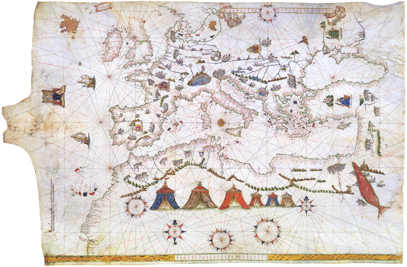
Mynd:Maggiolo - Portolankarte - 1541.png
Stærð þessarar forskoðunar: 800 × 524 mynddílar Aðrar upplausnir: 320 × 210 mynddílar | 640 × 420 mynddílar | 1.024 × 671 mynddílar | 1.312 × 860 mynddílar.
Upphafleg skrá (1.312 × 860 mynddílar, skráarstærð: 2,21 MB, MIME-gerð: image/png)
Lýsing
| Lýsing |
Deutsch: Vesconte Maggiolo, Portolankarte (1541)
Français : Portulan de Vesconte Maggiolo (1541) Europe, Méditerranée et Afrique du Nord |
||||||||||||||||||||||
| Dagsetning | |||||||||||||||||||||||
| Uppruni | Kartenabteilung der Staatsbibliothek zu Berlin] | ||||||||||||||||||||||
| Höfundarréttarhafi |
|
||||||||||||||||||||||
| Aðrar útgáfur | Derivative works of this file: Maggiolo - Portolankarte - 1541 Black Sea.PNG | ||||||||||||||||||||||
Leyfisupplýsingar:
|
This is a faithful photographic reproduction of a two-dimensional, public domain work of art. The work of art itself is in the public domain for the following reason:
The official position taken by the Wikimedia Foundation is that "faithful reproductions of two-dimensional public domain works of art are public domain".
This photographic reproduction is therefore also considered to be in the public domain in the United States. In other jurisdictions, re-use of this content may be restricted; see Reuse of PD-Art photographs for details. | ||||
Breytingaskrá skjals
Smelltu á dagsetningu eða tímasetningu til að sjá hvernig hún leit þá út.
| Dagsetning/Tími | Smámynd | Víddir | Notandi | Athugasemd | |
|---|---|---|---|---|---|
| núverandi | 23. júní 2018 kl. 20:01 | | 1.312 × 860 (2,21 MB) | SteinsplitterBot | Bot: Image rotated by 270° |
| 11. desember 2015 kl. 10:00 |  | 860 × 1.312 (2,22 MB) | SteinsplitterBot | Bot: Image rotated by 90° | |
| 14. september 2005 kl. 09:36 |  | 1.312 × 860 (2,33 MB) | Frank Schulenburg | ||
| 14. september 2005 kl. 09:03 |  | 1.312 × 860 (2,37 MB) | Frank Schulenburg | Vesconte Maggiolo, Portolankarte (1541) Category:16th century maps |
Skráartenglar
Eftirfarandi síða notar þessa skrá:
Altæk notkun skráar
Eftirfarandi wikar nota einnig þessa skrá:
- Notkun á ar.wikipedia.org
- Notkun á bg.wikipedia.org
- Notkun á ca.wikipedia.org
- Notkun á de.wikipedia.org
- Notkun á el.wikipedia.org
- Notkun á en.wikipedia.org
- Notkun á es.wikipedia.org
- Notkun á fr.wikipedia.org
- Notkun á he.wikipedia.org
- Notkun á hy.wikipedia.org
- Notkun á ky.wikipedia.org
- Notkun á no.wikipedia.org
- Notkun á nrm.wikipedia.org
- Notkun á oc.wikipedia.org
- Notkun á sl.wikipedia.org