Mynd:Location Ardennes.PNG
Það er engin hærri upplausn til.
Location_Ardennes.PNG (506 × 439 mynddílar, skráarstærð: 40 KB, MIME-gerð: image/png)
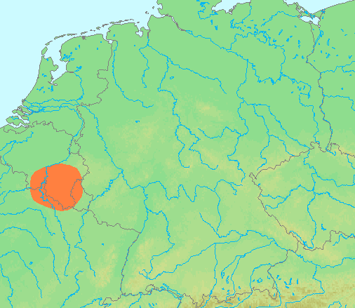
| Lýsing | Locator maps for mountain ranges : Location Ardennes.PNG |
| Uppruni | demis maps, see below |
| Höfundarréttarhafi | 13:44, 29 June 2007 (UTC) |
This image is in the public domain because it came from the site https://www.demis.nl/products/web-map-server/examples/ and was released by the copyright holder. Permission is granted to copy, distribute and/or modify this map since it is based on free of copyright images from: www.demis.nl. See also approval email on de.wp and its clarification.
|
| This work has been released into the public domain by its copyright holder, www.demis.nl. This applies worldwide. In some countries this may not be legally possible; if so: www.demis.nl grants anyone the right to use this work for any purpose, without any conditions, unless such conditions are required by law.
|
Breytingaskrá skjals
Smelltu á dagsetningu eða tímasetningu til að sjá hvernig hún leit þá út.
| Dagsetning/Tími | Smámynd | Víddir | Notandi | Athugasemd | |
|---|---|---|---|---|---|
| núverandi | 29. júní 2007 kl. 13:42 | | 506 × 439 (40 KB) | Michiel1972 | {{Information |Description=Locator maps for mountain ranges : {{subst:PAGENAME}} |Source=demis maps, see below |Date= |Author={{Statistics Netherlands map}} |Permission=see below |other_versions= }} {{PD-Demis}} [[Category:Maps of mountain_ranges_of_Eu |
Skráartenglar
Eftirfarandi síða notar þessa skrá:
Altæk notkun skráar
Eftirfarandi wikar nota einnig þessa skrá:
- Notkun á af.wikipedia.org
- Notkun á ar.wikipedia.org
- Notkun á arz.wikipedia.org
- Notkun á be-tarask.wikipedia.org
- Notkun á ca.wikipedia.org
- Notkun á ceb.wikipedia.org
- Notkun á cs.wikipedia.org
- Notkun á de.wikipedia.org
- Notkun á de.wiktionary.org
- Notkun á en.wikipedia.org
- Notkun á eo.wikipedia.org
- Notkun á es.wikipedia.org
- Notkun á eu.wikipedia.org
- Notkun á fy.wikipedia.org
- Notkun á hy.wikipedia.org
- Notkun á ia.wikipedia.org
- Notkun á incubator.wikimedia.org
- Notkun á ja.wikipedia.org
- Notkun á ko.wikipedia.org
- Notkun á li.wikipedia.org
- Notkun á lt.wikipedia.org
- Notkun á ms.wikipedia.org
- Notkun á pcd.wikipedia.org
- Notkun á pl.wikipedia.org
- Notkun á pl.wiktionary.org
- Notkun á pnb.wikipedia.org
- Notkun á simple.wikipedia.org
- Notkun á sk.wikipedia.org
- Notkun á sv.wikipedia.org
- Notkun á th.wikipedia.org
- Notkun á uk.wikipedia.org
- Notkun á wa.wikipedia.org
- Notkun á www.wikidata.org
- Notkun á zh-yue.wikipedia.org
- Notkun á zh.wikipedia.org