Mynd:Iceberg with hole around Cape York, Greenland edit.jpg

Stærð þessarar forskoðunar: 800 × 527 mynddílar Aðrar upplausnir: 320 × 211 mynddílar | 640 × 421 mynddílar | 1.024 × 674 mynddílar | 1.280 × 843 mynddílar | 2.560 × 1.685 mynddílar | 3.412 × 2.246 mynddílar.
Upphafleg skrá (3.412 × 2.246 mynddílar, skráarstærð: 4,4 MB, MIME-gerð: image/jpeg)
Lýsing
| Lýsing |
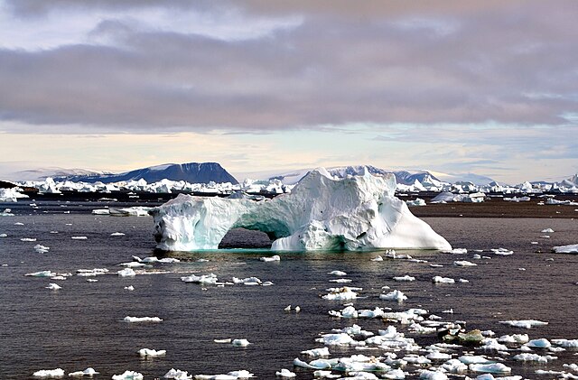
English: Icebergs around Cape York,Greenland. The icebergs are beautiful and display many interesting shapes. You could see the iceberg with a hole at the image. The hole was caused by weathering effects - erosion by waves, wind and melting.
Français : Des Icebergs près de Cape York, au Groenland. Les icebergs ont des formes très variées. Celui-ci est orné d'un trou, dû aux actions des vagues et de la fonte de la glace.
עברית: קרחונים בסביבת קייפ יורק, גרינלנד. הקרחונים היפים מציגים צורות מעניינות רבות. ניתן לראות קרחון עם חור במרכזו באמצע התמונה. החור נגרם על ידי השפעות מזג האוויר - הרס על ידי גלים, רוח, ונמיסה. |
| Dagsetning | |
| Uppruni | eigin skrá |
| Höfundarréttarhafi | This image was edited byUser:CillanXC |
| Camera location | | View this and other nearby images on: OpenStreetMap |
|---|
|

Leyfisupplýsingar:
I, the copyright holder of this work, hereby publish it under the following licenses:

|
Gefið er leyfi til að afrita, dreifa og/eða breyta þessu skjali samkvæmt Frjálsa GNU Free Documentation License, útgáfu 1.2 eða nýrri, sem gefið er út af Frjálsu hugbúnaðarstofnuninni með engum breytingum þar á. Afrit af leyfinu er innifalið í kaflanum GNU Free Documentation License. |
This file is licensed under the Creative Commons Attribution-Share Alike 3.0 Unported, 2.5 Generic, 2.0 Generic and 1.0 Generic license.
- Þér er frjálst:
- að deila – að afrita, deila og yfirfæra verkið
- að blanda – að breyta verkinu
- Undir eftirfarandi skilmálum:
- tilvísun höfundarréttar – Þú verður að tilgreina viðurkenningu á höfundarréttindum, gefa upp tengil á notkunarleyfið og gefa til kynna ef breytingar hafa verið gerðar. Þú getur gert þetta á einhvern ásættanlegan máta, en ekki á nokkurn þann hátt sem bendi til þess að leyfisveitandinn styðji þig eða notkun þína á verkinu.
- Deila eins – Ef þú breytir, yfirfærir eða byggir á þessu efni, þá mátt þú eingöngu dreifa því verki með sama eða svipuðu leyfi og upprunalega verkið er með.
Þú mátt velja notkunarleyfi að eigin vali.
Breytingaskrá skjals
Smelltu á dagsetningu eða tímasetningu til að sjá hvernig hún leit þá út.
| Dagsetning/Tími | Smámynd | Víddir | Notandi | Athugasemd | |
|---|---|---|---|---|---|
| núverandi | 7. janúar 2012 kl. 18:51 | | 3.412 × 2.246 (4,4 MB) | Soerfm | Brightness |
| 2. október 2007 kl. 15:16 |  | 3.412 × 2.246 (4,14 MB) | CillanXC | Edit for WP:FPC. |
Skráartenglar
Eftirfarandi síða notar þessa skrá:
Altæk notkun skráar
Eftirfarandi wikar nota einnig þessa skrá:
- Notkun á arc.wikipedia.org
- Notkun á ar.wikipedia.org
- Notkun á azb.wikipedia.org
- Notkun á az.wikipedia.org
- Notkun á ca.wikipedia.org
- Notkun á diq.wikipedia.org
- Notkun á en.wikipedia.org
- User:CillanXC
- Wikipedia:Featured pictures thumbs/08
- Wikipedia:Featured picture candidates/October-2007
- Wikipedia:Wikipedia Signpost/2007-10-08/Features and admins
- Wikipedia:Featured picture candidates/Iceberg with hole edit.jpg
- Wikipedia:Picture of the day/February 2008
- Template:POTD/2008-02-07
- Wikipedia:Featured pictures/Natural phenomena/Others
- User:Carcharoth/Arctic articles
- Wikipedia:WikiProject Arctic
- Wikipedia:Wikipedia Signpost/2007-10-08/SPV
- User:BLADIMIR MOYANO
- North American Arctic
- User talk:Mbz1/a7
- User:CillanXC/archive
- User talk:Mbz1/a77
- User:Mbz1
- Wikipedia:Wikipedia Signpost/Single/2007-10-08
- Notkun á eo.wikipedia.org
- Notkun á es.wikipedia.org
- Notkun á fa.wikipedia.org
- Notkun á hy.wikipedia.org
- Notkun á incubator.wikimedia.org
- Notkun á it.wikipedia.org
- Notkun á ka.wikipedia.org
- Notkun á lt.wikipedia.org
- Notkun á lv.wikipedia.org
- Notkun á lv.wiktionary.org
- Notkun á mk.wikipedia.org
- Notkun á ms.wikipedia.org
- Notkun á my.wikipedia.org
- Notkun á nn.wikipedia.org
- Notkun á pa.wikipedia.org
- Notkun á pl.wikipedia.org
- Notkun á pnb.wikipedia.org
- Notkun á ru.wikipedia.org
- Notkun á ru.wiktionary.org
- Notkun á sh.wikipedia.org
Skoða frekari altæka notkun þessarar skráar.