Mynd:Hungary topographic map.jpg
Stærð þessarar forskoðunar: 800 × 549 mynddílar Aðrar upplausnir: 320 × 220 mynddílar | 640 × 439 mynddílar | 912 × 626 mynddílar.
Upphafleg skrá (912 × 626 mynddílar, skráarstærð: 75 KB, MIME-gerð: image/jpeg)
Lýsing
| Lýsing |
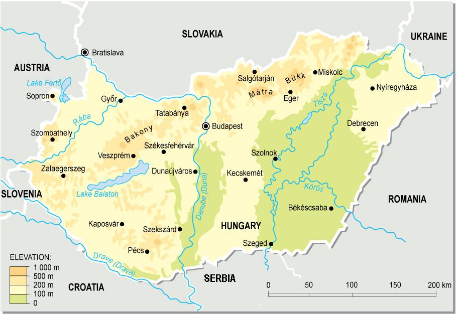
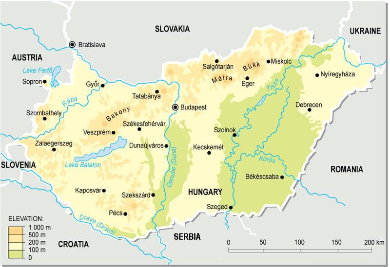
English: Topographic map of Hungary.
Deutsch: Topografische Karte Ungarns. |
| Dagsetning | |
| Uppruni | eigin skrá (from a PD map collection. Mistakes fixed) |
| Höfundarréttarhafi | Cserlajos |
| Aðrar útgáfur |
|


|
This map has been uploaded by Electionworld from en.wikipedia.org to enable the |


Leyfisupplýsingar:
| This work has been released into the public domain by its author, Cserlajos. This applies worldwide. In some countries this may not be legally possible; if so: |
Breytingaskrá skjals
Smelltu á dagsetningu eða tímasetningu til að sjá hvernig hún leit þá út.
| Dagsetning/Tími | Smámynd | Víddir | Notandi | Athugasemd | |
|---|---|---|---|---|---|
| núverandi | 23. desember 2006 kl. 23:51 | | 912 × 626 (75 KB) | Electionworld | {{ew|en|Cserlajos}} == Summary == From a pd map collection. Mistakes fixed by User:cserlajos. == Licensing == {{no rights reserved}} |
Skráartenglar
Eftirfarandi síða notar þessa skrá:
Altæk notkun skráar
Eftirfarandi wikar nota einnig þessa skrá:
- Notkun á azb.wikipedia.org
- Notkun á az.wikipedia.org
- Notkun á be-tarask.wikipedia.org
- Notkun á bg.wikipedia.org
- Notkun á bn.wikipedia.org
- Notkun á bs.wikipedia.org
- Notkun á cs.wikipedia.org
- Notkun á da.wikipedia.org
- Notkun á de.wikipedia.org
- Notkun á de.wikibooks.org
- Notkun á en.wikipedia.org
- Notkun á eu.wikipedia.org
- Notkun á fa.wikipedia.org
- Notkun á fi.wikipedia.org
- Notkun á fr.wikipedia.org
- Notkun á gl.wikipedia.org
- Notkun á gom.wikipedia.org
- Notkun á he.wikipedia.org
- Notkun á hr.wikipedia.org
- Notkun á hr.wiktionary.org
- Notkun á hu.wikipedia.org
- Notkun á hu.wikibooks.org
- Notkun á io.wikipedia.org
Skoða frekari altæka notkun þessarar skráar.