Mynd:Geographic map of Somaliland.svg

Stærð þessarar PNG forskoðunar á SVG skránni: 800 × 506 mynddílar. Aðrar upplausnir: 320 × 202 mynddílar | 640 × 405 mynddílar | 1.024 × 648 mynddílar | 1.280 × 810 mynddílar | 2.560 × 1.619 mynddílar | 4.110 × 2.600 mynddílar.
Upphafleg skrá (SVG-skrá, að nafni til 4.110 × 2.600 mynddílar, skráarstærð: 11,09 MB)
Lýsing
| Lýsing |
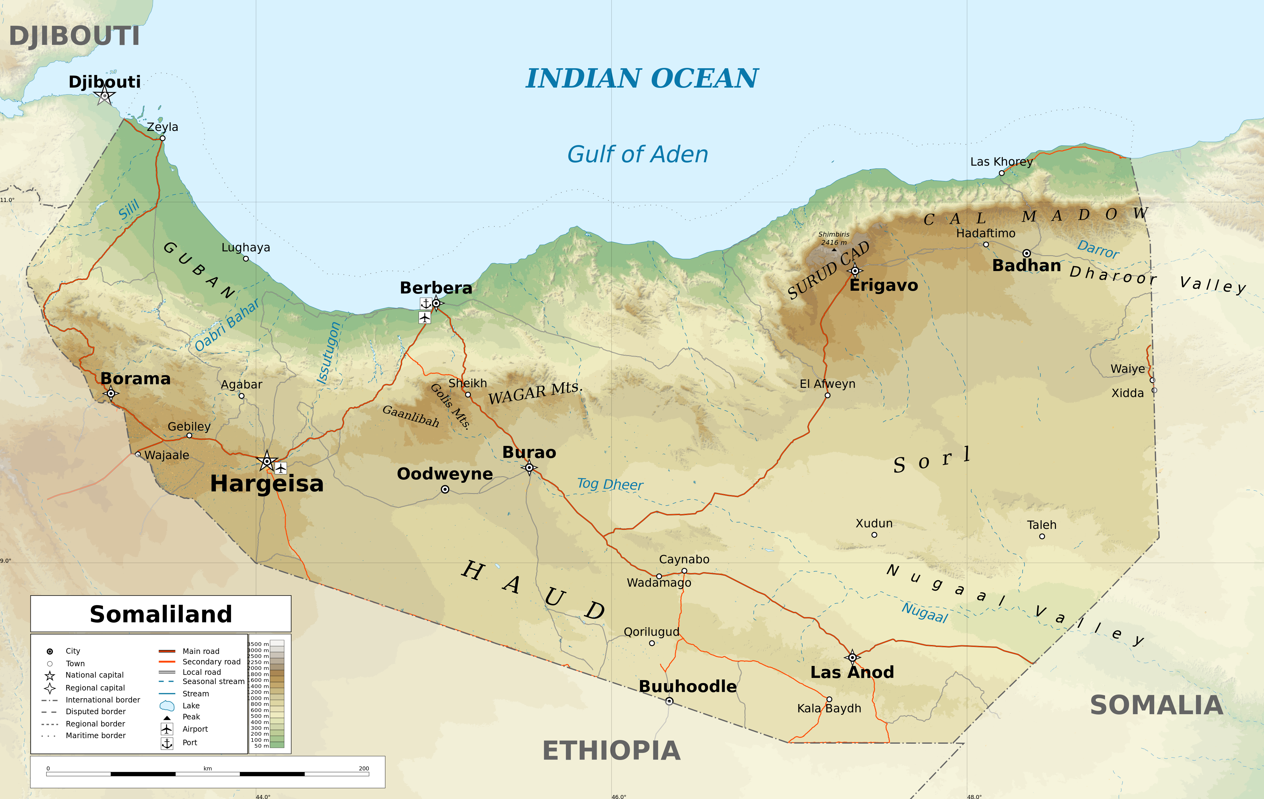
English: Geographic map of Somaliland. Geographic limits of the map:
|
| Dagsetning | |
| Uppruni |
eigin skrá
|
| Höfundarréttarhafi | Ikonact |
| Réttindi (Endurnotkun á þessari skrá) |
Any use of this map is subject of the license(s) stated below with the condition that you credit (Wikimedia Commons user: Ikonact) as the author . A message with a reply address would also be greatly appreciated. |
| Aðrar útgáfur |
[]
|
| SVG genesis |


Assessment
|
Leyfisupplýsingar:
I, the copyright holder of this work, hereby publish it under the following license:
This file is licensed under the Creative Commons Attribution-Share Alike 4.0 International license.
- Þér er frjálst:
- að deila – að afrita, deila og yfirfæra verkið
- að blanda – að breyta verkinu
- Undir eftirfarandi skilmálum:
- tilvísun höfundarréttar – Þú verður að tilgreina viðurkenningu á höfundarréttindum, gefa upp tengil á notkunarleyfið og gefa til kynna ef breytingar hafa verið gerðar. Þú getur gert þetta á einhvern ásættanlegan máta, en ekki á nokkurn þann hátt sem bendi til þess að leyfisveitandinn styðji þig eða notkun þína á verkinu.
- Deila eins – Ef þú breytir, yfirfærir eða byggir á þessu efni, þá mátt þú eingöngu dreifa því verki með sama eða svipuðu leyfi og upprunalega verkið er með.
Breytingaskrá skjals
Smelltu á dagsetningu eða tímasetningu til að sjá hvernig hún leit þá út.
| Dagsetning/Tími | Smámynd | Víddir | Notandi | Athugasemd | |
|---|---|---|---|---|---|
| núverandi | 13. febrúar 2022 kl. 17:20 | | 4.110 × 2.600 (11,09 MB) | Jacob300 | Reverted to version as of 22:29, 26 August 2021 (UTC) |
| 27. ágúst 2021 kl. 08:01 |  | 4.110 × 2.600 (11,27 MB) | Ikonact | Reverted to version as of 11:59, 26 August 2021 (UTC) - the eastern border is disputed and should stay as such | |
| 26. ágúst 2021 kl. 22:29 |  | 4.110 × 2.600 (11,09 MB) | Siirski | Corrected eastern border | |
| 26. ágúst 2021 kl. 11:59 |  | 4.110 × 2.600 (11,27 MB) | Ikonact | final touch | |
| 26. ágúst 2021 kl. 09:37 |  | 4.110 × 2.600 (11,36 MB) | Ikonact | legend, names in En | |
| 25. ágúst 2021 kl. 20:47 |  | 4.110 × 2.600 (11,33 MB) | Ikonact | + mnts nammes | |
| 25. ágúst 2021 kl. 20:07 |  | 4.110 × 2.600 (11,32 MB) | Ikonact | font | |
| 25. ágúst 2021 kl. 20:03 |  | 4.110 × 2.600 (11,32 MB) | Ikonact | more data | |
| 24. ágúst 2021 kl. 12:56 |  | 4.110 × 2.600 (16,17 MB) | Ikonact | == {{int:filedesc}} == {{Information |description={{en|Geographic map of {{W|Somaliland}}. Geographic limits of the map:}} *N: 12.12° N *S: 7.69° N *W: 42.56° E *E: 49.67° E Equidistant Cylindrical projection; WGS 84 datum |date=2021-08-24 |source={{own}} *Sources of data:<br/> **Topography: SRTM3 v4 (public domain);<br/> **Rivers and water bodies: Natural Earth, © OpenStreetMap contributors **Borders and towns: © OpenStreetMap contributors;<br/> *Tool:<br/> **The map is created with Octave s... |
Skráartenglar
Eftirfarandi síða notar þessa skrá:
Altæk notkun skráar
Eftirfarandi wikar nota einnig þessa skrá:
- Notkun á ar.wikipedia.org
- Notkun á bg.wikipedia.org
- Notkun á ca.wikipedia.org
- Notkun á da.wikipedia.org
- Notkun á de.wikipedia.org
- Notkun á en.wikipedia.org
- Notkun á fr.wikipedia.org
- Notkun á ga.wikipedia.org
- Notkun á gl.wikipedia.org
- Notkun á hu.wikipedia.org
- Notkun á id.wikipedia.org
- Notkun á ja.wikipedia.org
- Notkun á ku.wikipedia.org
- Notkun á lt.wikipedia.org
- Notkun á ru.wikivoyage.org
- Notkun á sh.wikipedia.org
- Notkun á so.wikipedia.org
- Notkun á sv.wikipedia.org
- Notkun á www.wikidata.org
- Notkun á zh.wikipedia.org