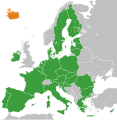
Mynd:European Union Iceland Locator.svg

Stærð þessarar PNG forskoðunar á SVG skránni: 587 × 600 mynddílar. Aðrar upplausnir: 235 × 240 mynddílar | 470 × 480 mynddílar | 752 × 768 mynddílar | 1.002 × 1.024 mynddílar | 2.004 × 2.048 mynddílar | 593 × 606 mynddílar.
Upphafleg skrá (SVG-skrá, að nafni til 593 × 606 mynddílar, skráarstærð: 711 KB)
Breytingaskrá skjals
Smelltu á dagsetningu eða tímasetningu til að sjá hvernig hún leit þá út.
| Dagsetning/Tími | Smámynd | Víddir | Notandi | Athugasemd | |
|---|---|---|---|---|---|
| núverandi | 20. nóvember 2022 kl. 13:40 |  | 593 × 606 (711 KB) | M.Bitton | Reverted to version as of 01:53, 19 November 2022 (UTC): per COM:OVERWRITE. 2016 was 6 years ago, making this map stable. Feel free to upload under a different name |
| 20. nóvember 2022 kl. 09:00 |  | 593 × 606 (714 KB) | Рагин1987 | Removed the gray square at the maritime borders of Spain, also painted over Malta from blue to green (also a member of the EU). Slightly expanded the map to the borders of Georgia (the territory of Abkhazia), since Georgia, like Moldova, is a member of the Eastern Partnership, an associated trio and applied for EU membership. Please, before automatically referring to COM:OVERWRITE, take a close look at the history of the file, and the fact that its format was radically edited in 2016. | |
| 19. nóvember 2022 kl. 01:53 |  | 593 × 606 (711 KB) | M.Bitton | Reverted to version as of 12:05, 3 February 2020 (UTC): meaningless edit summary | |
| 18. nóvember 2022 kl. 12:54 |  | 593 × 606 (710 KB) | Рагин1987 | Small correction | |
| 3. febrúar 2020 kl. 12:05 |  | 593 × 606 (711 KB) | Darranc | Remove UK from EU | |
| 26. október 2016 kl. 18:21 |  | 680 × 520 (602 KB) | Giorgi Balakhadze | Rv of sockpuppet and per COM:OVERWRITE | |
| 15. mars 2015 kl. 21:00 |  | 680 × 520 (620 KB) | Leftcry | Update layout | |
| 11. júlí 2013 kl. 10:51 |  | 680 × 520 (307 KB) | Augusta 89 | Croatie (oubli) | |
| 11. júlí 2013 kl. 10:13 |  | 680 × 520 (309 KB) | Augusta 89 | Localisation des micro-États européens | |
| 1. júlí 2013 kl. 09:23 |  | 680 × 520 (318 KB) | Treehill | + croatia |
Skráartenglar
Það eru engar síður sem nota þessa skrá.
Altæk notkun skráar
Eftirfarandi wikar nota einnig þessa skrá:
- Notkun á de.wikipedia.org
- Notkun á en.wikipedia.org
- Notkun á en.wikinews.org
- Notkun á es.wikinews.org
- Notkun á fr.wikipedia.org
- Notkun á fr.wikinews.org
- Notkun á it.wikipedia.org
- Notkun á mk.wikipedia.org
- Notkun á pl.wikipedia.org
- Notkun á sv.wikipedia.org
- Notkun á tr.wikinews.org
- Notkun á uk.wikipedia.org
- Notkun á www.wikidata.org
- Notkun á zh.wikipedia.org
