Mynd:Europe in 1430.PNG
Stærð þessarar forskoðunar: 553 × 599 mynddílar Aðrar upplausnir: 221 × 240 mynddílar | 600 × 650 mynddílar.
Upphafleg skrá (600 × 650 mynddílar, skráarstærð: 69 KB, MIME-gerð: image/png)
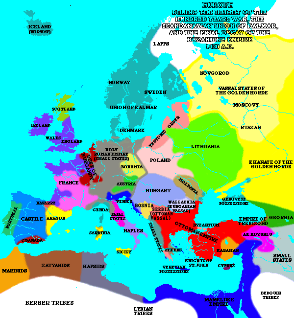
| Lýsing | A map of Europe in 1430. | ||
| Uppruni | [1] | ||
| Höfundarréttarhafi | Lynn H. Nelson | ||
| Réttindi (Endurnotkun á þessari skrá) |
|
_en.png)
.png)
.jpg)
Breytingaskrá skjals
Smelltu á dagsetningu eða tímasetningu til að sjá hvernig hún leit þá út.
| Dagsetning/Tími | Smámynd | Víddir | Notandi | Athugasemd | |
|---|---|---|---|---|---|
| núverandi | 10. maí 2020 kl. 20:16 | | 600 × 650 (69 KB) | Santasa99 | Per John V.A. Fine: The Late Medieval Balkans: A Critical Survey from the Late Twelfth Century to the Ottoman Conquest; Chapter 9. The Balkans in the Early Fifteenth Century - Bosnia after death of Tvrtko |
| 8. mars 2005 kl. 19:30 |  | 600 × 650 (44 KB) | Quadell | A map of Europe in 1430.{{PD}}Source:[http://www.ku.edu/kansas/medieval/108/lectures/]Category:Maps of EuropeCategory:Historical mapsCategory:1430 |
Skráartenglar
Eftirfarandi síða notar þessa skrá:
Altæk notkun skráar
Eftirfarandi wikar nota einnig þessa skrá:
- Notkun á ar.wikipedia.org
- Notkun á az.wikipedia.org
- Notkun á ba.wikipedia.org
- Notkun á bg.wikipedia.org
- Notkun á bn.wikipedia.org
- Notkun á bxr.wikipedia.org
- Notkun á ca.wikipedia.org
- Notkun á cs.wikipedia.org
- Notkun á de.wikipedia.org
- Notkun á el.wikipedia.org
- Notkun á en.wikipedia.org
- Notkun á en.wikibooks.org
- Notkun á es.wikipedia.org
- Notkun á fa.wikipedia.org
- Notkun á fi.wikipedia.org
- Notkun á fr.wikipedia.org
- Notkun á id.wikipedia.org
- Notkun á io.wikipedia.org
- Notkun á ka.wikipedia.org
- Notkun á mk.wikipedia.org
- Notkun á nds-nl.wikipedia.org
- Notkun á nl.wikipedia.org
- Notkun á nn.wikipedia.org
- Notkun á no.wikipedia.org
- Notkun á pnb.wikipedia.org
- Notkun á pt.wikipedia.org
- Notkun á ru.wikipedia.org
- Notkun á sa.wikipedia.org
- Notkun á scn.wikipedia.org
- Notkun á sh.wikipedia.org
- Notkun á simple.wikipedia.org
- Notkun á skr.wikipedia.org
- Notkun á sk.wikipedia.org
Skoða frekari altæka notkun þessarar skráar.