Mynd:Eruption of Eyjafjallajökull Volcano, Iceland 2010-04-04 lrg.jpg

Upphafleg skrá(4.013 × 4.013 mynddílar, skráarstærð: 2,88 MB, MIME-gerð: image/jpeg)

Skrá þessi er af Wikimedia Commons, og deilt meðal annarra verkefna og nýtist því þar. Hér fyrir neðan er afrit af skráarsíðunni þar.

Lýsing

Lýsing
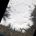
English: Lava continued to pour out of two fissures near Eyjafjallajökull as the eruption near the Fimmvörduháls Pass entered its third week. This satellite image shows the eruption on April 4, 2010. The original fissure—originally about 1,000 meters (3,000 feet) long and composed of several distinct vents—has coalesced into a single vent. The new fissure is hidden under a volcanic plume, likely composed primarily of steam. Black lava flows reach several kilometers north from the vents, eventually spilling into Hvannárgil and Hrunagil Canyons. This image was acquired by the Advanced Land Imager (ALI) aboard NASA’s Earth Observing-1 (EO-1) satellite.
Dagsetning
Uppruni http://earthobservatory.nasa.gov/NaturalHazards/view.php?id=43410
Höfundarréttarhafi NASA image by Robert Simmon
Aðrar útgáfur

Leyfisupplýsingar:

Public domain This file is in the public domain in the United States because it was solely created by NASA. NASA copyright policy states that "NASA material is not protected by copyright unless noted". (See Template:PD-USGov, NASA copyright policy page or JPL Image Use Policy.)
Warnings:
Annotations
InfoField
This image is annotated: View the annotations at Commons

Captions

Add a one-line explanation of what this file represents

Items portrayed in this file

depicts enska

4. apríl 2010

Breytingaskrá skjals

Smelltu á dagsetningu eða tímasetningu til að sjá hvernig hún leit þá út.

Dagsetning/TímiSmámyndVíddirNotandiAthugasemd
núverandi9. apríl 2010 kl. 09:25Smámynd útgáfunnar frá 9. apríl 2010, kl. 09:254.013 × 4.013 (2,88 MB)Captain-tucker{{Information |Description={{en|Lava continued to pour out of two fissures near Eyjafjallajökull as the eruption near the Fimmvörduháls Pass entered its third week. This satellite image shows the eruption on April 4, 2010. The original fissure—origin

Eftirfarandi síða notar þessa skrá:

Lýsigögn