Mynd:CIA map Central America & Caribbean.png

Stærð þessarar forskoðunar: 798 × 599 mynddílar Aðrar upplausnir: 320 × 240 mynddílar | 639 × 480 mynddílar | 1.023 × 768 mynddílar | 1.280 × 961 mynddílar | 1.390 × 1.044 mynddílar.
Upphafleg skrá (1.390 × 1.044 mynddílar, skráarstærð: 1,6 MB, MIME-gerð: image/png)
JAY TAMBU MAYALA ENGANGE PAR LA CIA
Lýsing
| Lýsing |
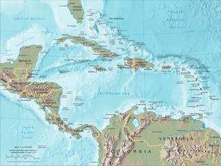
English: Map of Central America and the Caribbean by the CIA World Factbook Español: Mapa de Centroamérica y el Caribe en el CIA World Factbook |
| Uppruni | Transferred from en.wikipedia to Commons. Original source is/was CIA The World Factbook |
| Höfundarréttarhafi | U.S. Central Intelligence Agency (CIA) |
| Aðrar útgáfur |


Leyfisupplýsingar:
This image is in the public domain because it contains materials that originally came from the United States Central Intelligence Agency's World Factbook.
|
 |
Original upload log
The original description page was here. All following user names refer to en.wikipedia.
- 2007-09-20 19:45 Brianski 1392×1066×8 (1720810 bytes) == Summary == Map of [[Central America]], see https://www.cia.gov/library/publications/the-world-factbook/docs/refmaps.html. == License == {{PD-USGov-CIA-WF}}
Breytingaskrá skjals
Smelltu á dagsetningu eða tímasetningu til að sjá hvernig hún leit þá út.
| Dagsetning/Tími | Smámynd | Víddir | Notandi | Athugasemd | |
|---|---|---|---|---|---|
| núverandi | 10. júní 2010 kl. 22:22 | | 1.390 × 1.044 (1,6 MB) | Jahoe | better compression (no visible alterations) |
| 26. ágúst 2008 kl. 08:45 |  | 1.390 × 1.044 (2,3 MB) | Bowlhover | Cropped title. | |
| 25. september 2007 kl. 22:01 |  | 1.392 × 1.066 (1,64 MB) | Paintman | {{Information |Description=Map of en:Central America, see https://www.cia.gov/library/publications/the-world-factbook/docs/refmaps.html. |Source=Originally from [http://en.wikipedia.org en.wikipedia]; description page is/was [http://en.wikipedia.org |
Skráartenglar
Eftirfarandi síða notar þessa skrá:
Altæk notkun skráar
Eftirfarandi wikar nota einnig þessa skrá:
- Notkun á als.wikipedia.org
- Notkun á an.wikipedia.org
- Notkun á ar.wikipedia.org
- Notkun á ast.wikipedia.org
- Notkun á bat-smg.wikipedia.org
- Notkun á ba.wikipedia.org
- Notkun á bm.wikipedia.org
- Notkun á bn.wikipedia.org
- Notkun á bo.wikipedia.org
- Notkun á br.wikipedia.org
- Notkun á bs.wikipedia.org
- Notkun á co.wikipedia.org
- Notkun á cs.wikipedia.org
- Notkun á da.wikipedia.org
- Notkun á de.wikipedia.org
- Notkun á de.wiktionary.org
- Notkun á el.wikipedia.org
- Notkun á en.wikipedia.org
- Piracy in the Caribbean
- Portal:Latin America/Portals
- Wikipedia:WikiProject Caribbean
- Portal:Piracy/Selected article
- User:Saaristo
- Portal:Piracy/Selected article/10
- User:Zero Gravity/Proposal
- Ocean fisheries
- Wikipedia:Graphics Lab/Image workshop/Archive/Sep 2008
- Portal:Bolivia
- Portal:Bolivia/Related portals
- User:StAnMc18/sandbox
- Notkun á en.wikibooks.org
- Notkun á eo.wikipedia.org
- Notkun á es.wikipedia.org
- Notkun á eu.wikipedia.org
- Notkun á ext.wikipedia.org
- Notkun á fa.wikipedia.org
Skoða frekari altæka notkun þessarar skráar.