Mynd:506-Castile 1210.png
Það er engin hærri upplausn til.
506-Castile_1210.png (474 × 506 mynddílar, skráarstærð: 138 KB, MIME-gerð: image/png)
Lýsing
| Lýsing |
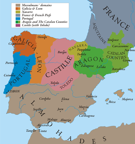
English: This map show Al-Andalus (Almohades) and European Christian kingdoms. 12th-13th centuries. It´s made from "The Historical Atlas by William R. Shepherd, 1926". |
| Dagsetning | 7/05/2010 |
| Uppruni | eigin skrá |
| Höfundarréttarhafi | Alexandre Vigo |
| Réttindi (Endurnotkun á þessari skrá) |
Texas University |
| Aðrar útgáfur | http://www.lib.utexas.edu/maps/historical/spanish_kingdoms_1210.jpg |

|
This historical map image could be re-created using vector graphics as an SVG file. This has several advantages; see Commons:Media for cleanup for more information. If an SVG form of this image is available, please upload it and afterwards replace this template with
{{vector version available|new image name}}.
It is recommended to name the SVG file “506-Castile 1210.svg”—then the template Vector version available (or Vva) does not need the new image name parameter. |
Leyfisupplýsingar:
I, the copyright holder of this work, hereby publish it under the following licenses:

|
Gefið er leyfi til að afrita, dreifa og/eða breyta þessu skjali samkvæmt Frjálsa GNU Free Documentation License, útgáfu 1.2 eða nýrri, sem gefið er út af Frjálsu hugbúnaðarstofnuninni með engum breytingum þar á. Afrit af leyfinu er innifalið í kaflanum GNU Free Documentation License. |
Þessi skrá er með Creative Commons Tilvísun-DeilaEins 3.0 Óstaðfært notkunarleyfi.
- Þér er frjálst:
- að deila – að afrita, deila og yfirfæra verkið
- að blanda – að breyta verkinu
- Undir eftirfarandi skilmálum:
- tilvísun höfundarréttar – Þú verður að tilgreina viðurkenningu á höfundarréttindum, gefa upp tengil á notkunarleyfið og gefa til kynna ef breytingar hafa verið gerðar. Þú getur gert þetta á einhvern ásættanlegan máta, en ekki á nokkurn þann hátt sem bendi til þess að leyfisveitandinn styðji þig eða notkun þína á verkinu.
- Deila eins – Ef þú breytir, yfirfærir eða byggir á þessu efni, þá mátt þú eingöngu dreifa því verki með sama eða svipuðu leyfi og upprunalega verkið er með.
Þú mátt velja notkunarleyfi að eigin vali.
Breytingaskrá skjals
Smelltu á dagsetningu eða tímasetningu til að sjá hvernig hún leit þá út.
| Dagsetning/Tími | Smámynd | Víddir | Notandi | Athugasemd | |
|---|---|---|---|---|---|
| núverandi | 12. maí 2010 kl. 20:58 | | 474 × 506 (138 KB) | Alexandre Vigo~commonswiki | {{Information |Description={{en|1=This map show Al-Andalus (Almohades) and European Christian kingdoms. 12th-13th centuries. It´s made from "The Historical Atlas by William R. Shepherd, 1926".}} |Source={{own}} |Author=[[User:Alexandre Vigo|Alexandre Vig |
Skráartenglar
Eftirfarandi síða notar þessa skrá:
Altæk notkun skráar
Eftirfarandi wikar nota einnig þessa skrá:
- Notkun á ar.wikipedia.org
- Notkun á arz.wikipedia.org
- Notkun á ast.wikipedia.org
- Notkun á azb.wikipedia.org
- Notkun á az.wikipedia.org
- Notkun á ba.wikipedia.org
- Notkun á be.wikipedia.org
- Notkun á br.wikipedia.org
- Notkun á ca.wikipedia.org
- Notkun á cs.wikipedia.org
- Notkun á cy.wikipedia.org
- Notkun á de.wikipedia.org
- Notkun á en.wikipedia.org
- Notkun á en.wikibooks.org
- Notkun á es.wikipedia.org
- Notkun á et.wikipedia.org
- Notkun á fa.wikipedia.org
- Notkun á fr.wikipedia.org
Skoða frekari altæka notkun þessarar skráar.