Mynd:Relief Map of Poland.svg

Stærð þessarar PNG forskoðunar á SVG skránni: 617 × 600 mynddílar. Aðrar upplausnir: 247 × 240 mynddílar | 494 × 480 mynddílar | 790 × 768 mynddílar | 1.053 × 1.024 mynddílar | 2.107 × 2.048 mynddílar | 861 × 837 mynddílar.
Upphafleg skrá (SVG-skrá, að nafni til 861 × 837 mynddílar, skráarstærð: 4 MB)
Lýsing
| Lýsing |
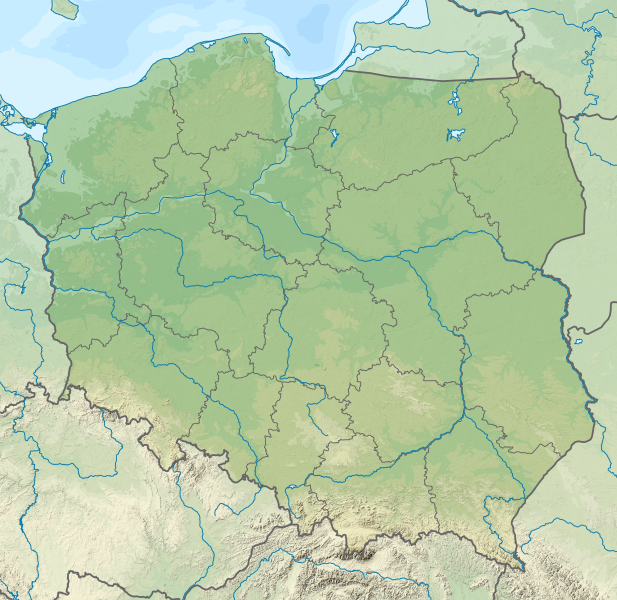
Deutsch: Positionskarte von Polen
Quadratische Plattkarte, N-S-Streckung 160 %. Geographische Begrenzung der Karte:
English: Location map of Poland
Equirectangular projection, N/S stretching 160 %. Geographic limits of the map:
|
| Dagsetning | |
| Uppruni |
eigin skrá This vector image includes elements that have been taken or adapted from this file: This vector image includes elements that have been taken or adapted from this file: |
| Höfundarréttarhafi |
TUBS |
| Aðrar útgáfur |
|
| SVG genesis | This map was created with Adobe Illustrator by TUBS. |


Leyfisupplýsingar:
I, the copyright holder of this work, hereby publish it under the following license:
Þessi skrá er með Creative Commons Tilvísun-DeilaEins 3.0 Óstaðfært notkunarleyfi.
- Þér er frjálst:
- að deila – að afrita, deila og yfirfæra verkið
- að blanda – að breyta verkinu
- Undir eftirfarandi skilmálum:
- tilvísun höfundarréttar – Þú verður að tilgreina viðurkenningu á höfundarréttindum, gefa upp tengil á notkunarleyfið og gefa til kynna ef breytingar hafa verið gerðar. Þú getur gert þetta á einhvern ásættanlegan máta, en ekki á nokkurn þann hátt sem bendi til þess að leyfisveitandinn styðji þig eða notkun þína á verkinu.
- Deila eins – Ef þú breytir, yfirfærir eða byggir á þessu efni, þá mátt þú eingöngu dreifa því verki með sama eða svipuðu leyfi og upprunalega verkið er með.

|
I'd greatly appreciate, that you attribute this media file to Wikimedia Commons, if used outside Wikipedia or Commons. For use in publications such as books, newspapers, blogs, websites, please insert here the following line:
|
Breytingaskrá skjals
Smelltu á dagsetningu eða tímasetningu til að sjá hvernig hún leit þá út.
| Dagsetning/Tími | Smámynd | Víddir | Notandi | Athugasemd | |
|---|---|---|---|---|---|
| núverandi | 30. nóvember 2021 kl. 23:20 | | 861 × 837 (4 MB) | Puck04 | fixed SVG code (was "W3C-invalid") + cleanup using text editor; contains raster graphics however |
| 3. febrúar 2021 kl. 20:54 |  | 861 × 837 (4,18 MB) | SANtosito | Vectorized topo | |
| 30. nóvember 2011 kl. 21:52 |  | 861 × 837 (4,87 MB) | TUBS | == {{int:filedesc}} == {{Information |Description={{en|Relief map of Poland}} Equirectangular projection, N/S stretching 160 %. Geographic limits of the map: * N: 55.2° N * S: 48.7° N * W: 13.8° E * E: 24.5° E |Source={{own}}{{Adobe Il |
Skráartenglar
Eftirfarandi 2 síður nota þessa skrá:
Altæk notkun skráar
Eftirfarandi wikar nota einnig þessa skrá:
- Notkun á ab.wikipedia.org
- Notkun á als.wikipedia.org
- Notkun á ar.wikipedia.org
- Notkun á av.wikipedia.org
- Notkun á azb.wikipedia.org
- Notkun á az.wikipedia.org
- Şablon:Yer xəritəsi Polşa
- Əyri meşə
- Slovinski Milli Parkı
- Dzivna boğazı
- Yamno gölü
- Baltik dili
- Şablon:Dil (coğrafiya)
- Şablon:Dil (coğrafiya)/doc
- Xel dili
- Blendovka səhrası
- Morskie Oko gölü
- Belka-Snejna mağarası
- Karsibur adası
- Ambarlar adası
- Qrabovski adası
- Haliç dağı
- Jives gölü
- Rozeve burnu
- Lısa-Gora dağı
- Avqustovskaya puşa
- Tuxolskie borı
- Rastoçe
- Rominten meşəsi
- Solina gölü
- Qartal Yuvası təbiət parkı
- Çarne gölü
- Pienini dağları
- Tatra Milli Parkı
- Notkun á ban.wikipedia.org
- Taman Nasional Tatra, Polandia
- Taman Nasional Bieszczady
- Lis taman nasional ring Polandia
- Taman Nasional Wielkopolska
- Taman Nasional Pieniny (Polandia)
- Taman Nasional Gorce
- Taman Nasional Babia Góra
- Taman Nasional Białowieża
- Taman Nasional Biebrza
- Taman Nasional Kampinos
- Taman Nasional Narew
- Taman Nasional Wigry
- Taman Nasional Magura
- Taman Nasional Roztocze
Skoða frekari altæka notkun þessarar skráar.