Mynd:Quercus macrocarpa range map 1.png
Stærð þessarar forskoðunar: 600 × 600 mynddílar Aðrar upplausnir: 240 × 240 mynddílar | 480 × 480 mynddílar | 768 × 768 mynddílar | 1.024 × 1.024 mynddílar | 2.048 × 2.048 mynddílar.
Upphafleg skrá (2.048 × 2.048 mynddílar, skráarstærð: 135 KB, MIME-gerð: image/png)
Lýsing
| Lýsing |
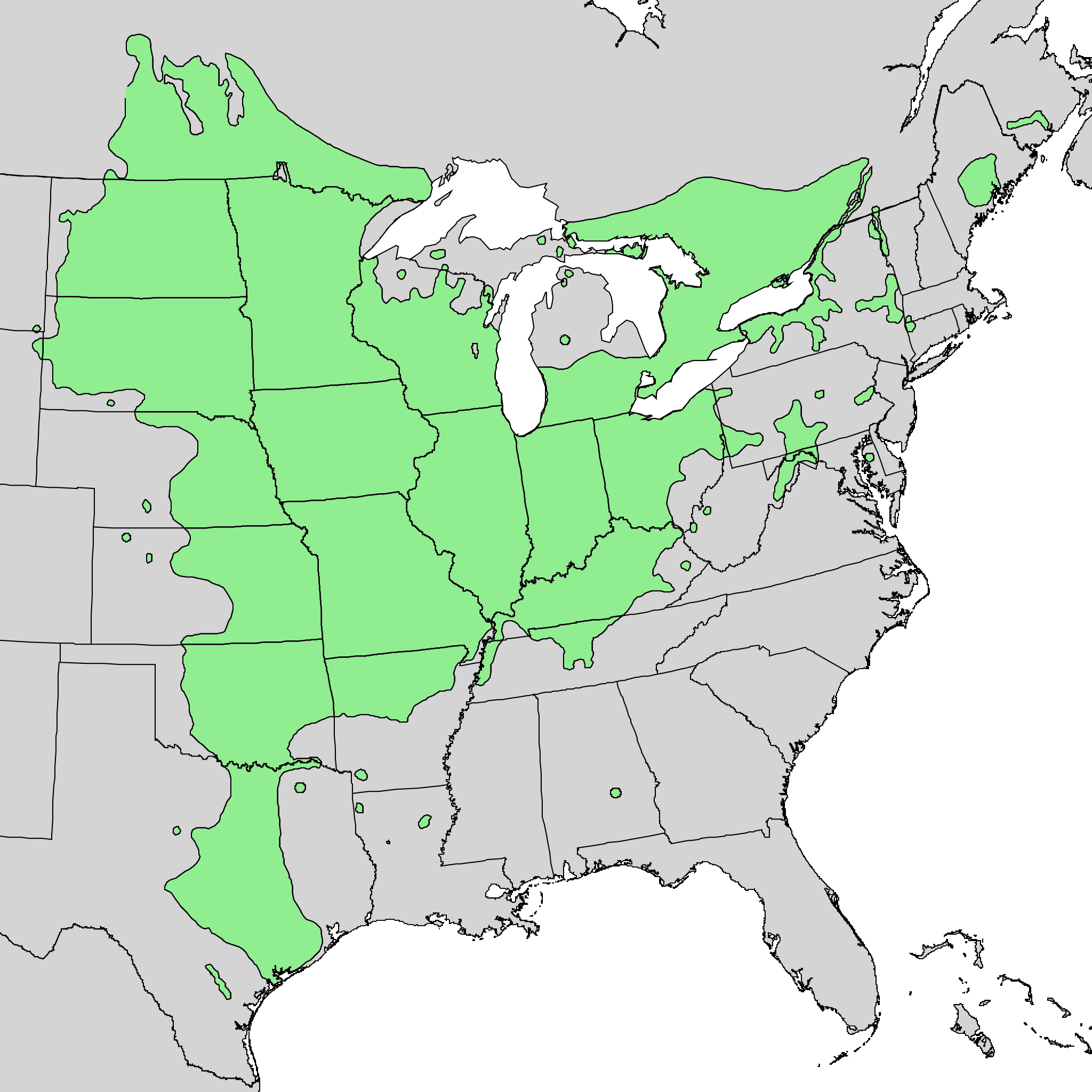
English: Range map of Quercus macrocarpa. |
| Dagsetning | |
| Uppruni | Digital representation of "Atlas of United States Trees" by Elbert L. Little, Jr. [1] |
| Höfundarréttarhafi | U.S. Geological Survey |
Leyfisupplýsingar:
This image is in the public domain in the United States because it only contains materials that originally came from the United States Geological Survey, an agency of the United States Department of the Interior. For more information, see the official USGS copyright policy.
|
Original upload log
Transferred from en.wikipedia to Commons by Quadell using CommonsHelper.
The original description page was here. All following user names refer to en.wikipedia.
- 2010-05-21 03:22 Masebrock 743×612× (139721 bytes) {{Information |Description=Range map of Quercus marcocarpa |Source=Digital representation of "Atlas of United States Trees" by Elbert L. Little, Jr. [http://esp.cr.usgs.gov/data/atlas/little/] |Date=1999 |Author=U.S. Geological Survey |Permission={{PD-US
Breytingaskrá skjals
Smelltu á dagsetningu eða tímasetningu til að sjá hvernig hún leit þá út.
| Dagsetning/Tími | Smámynd | Víddir | Notandi | Athugasemd | |
|---|---|---|---|---|---|
| núverandi | 20. október 2013 kl. 20:40 | | 2.048 × 2.048 (135 KB) | Nonenmac | Doubled the resolution so that more of the little green circles contain green instead of just black |
| 18. október 2013 kl. 14:47 |  | 1.024 × 1.024 (45 KB) | Nonenmac | larger png version without the vertical striping, directly from the same USGS source | |
| 7. september 2011 kl. 20:43 |  | 743 × 612 (136 KB) | File Upload Bot (Magnus Manske) | {{BotMoveToCommons|en.wikipedia|year={{subst:CURRENTYEAR}}|month={{subst:CURRENTMONTHNAME}}|day={{subst:CURRENTDAY}}}} {{Information |Description={{en|Range map of Quercus marcocarpa}} |Source=Transferred from [http://en.wikipedia.org en.wikipedia]; tran |
Skráartenglar
Eftirfarandi síða notar þessa skrá:
Altæk notkun skráar
Eftirfarandi wikar nota einnig þessa skrá:
- Notkun á ar.wikipedia.org
- Notkun á arz.wikipedia.org
- Notkun á ca.wikipedia.org
- Notkun á ceb.wikipedia.org
- Notkun á cs.wikipedia.org
- Notkun á en.wikipedia.org
- Notkun á es.wikipedia.org
- Notkun á fa.wikipedia.org
- Notkun á hu.wikipedia.org
- Notkun á it.wikipedia.org
- Notkun á ka.wikipedia.org
- Notkun á no.wikipedia.org
- Notkun á pl.wikipedia.org
- Notkun á ru.wikipedia.org
- Notkun á sv.wikipedia.org
- Notkun á uk.wikipedia.org
- Notkun á vi.wikipedia.org
- Notkun á www.wikidata.org
- Notkun á zh.wikipedia.org