Mynd:Mayotte topographic map-fr.svg

Stærð þessarar PNG forskoðunar á SVG skránni: 477 × 599 mynddílar. Aðrar upplausnir: 191 × 240 mynddílar | 382 × 480 mynddílar | 612 × 768 mynddílar | 815 × 1.024 mynddílar | 1.631 × 2.048 mynddílar | 1.033 × 1.297 mynddílar.
Upphafleg skrá (SVG-skrá, að nafni til 1.033 × 1.297 mynddílar, skráarstærð: 874 KB)
Lýsing
| Lýsing |
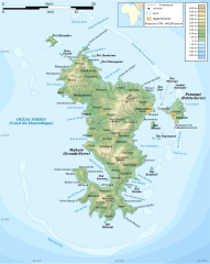
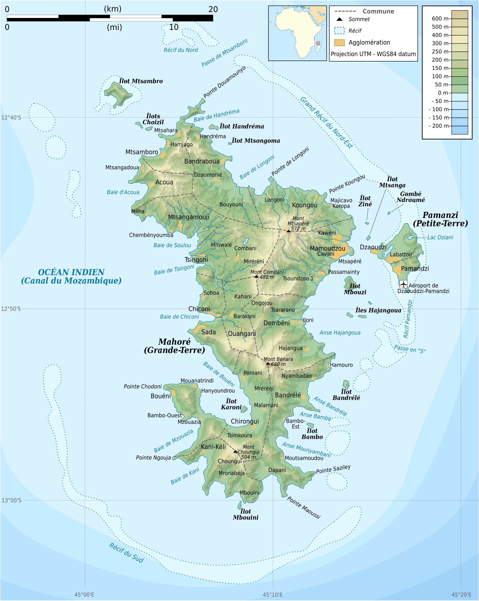
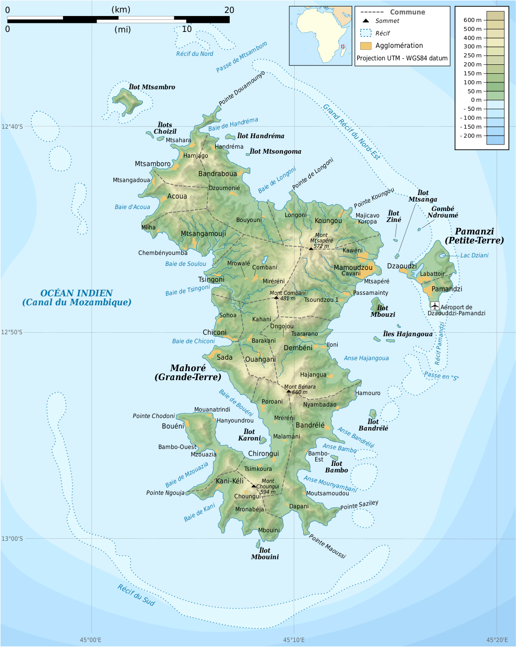
Français : Carte topographique de Mayotte en français. Utiliser la version PNG dans les articles pour un rendu plus rapide.
|
| Dagsetning | |
| Uppruni |
Own work. Sources of data:
|
| Höfundarréttarhafi | Rémi Kaupp |
| Aðrar útgáfur |
[]
|


English: This map has been created by Rémi Kaupp (User:Korrigan) and released under the license(s) stated below. You are free to use it for any purpose as long as you credit me and follow the terms of the license. You may need to credit the sources of data of the map (please check). Example:
Français : Cette carte a été créée par Rémi Kaupp (User:Korrigan) et placée sous la ou les licence(s) ci-dessous. Vous êtes libre de la réutiliser, tant que vous me citez en tant qu'auteur et suivez les instructions de la licence. Certaines sources de données de la carte doivent peut-être être créditées, veuillez vérifier. Exemple :
|
 |
Leyfisupplýsingar:
I, the copyright holder of this work, hereby publish it under the following licenses:

|
Gefið er leyfi til að afrita, dreifa og/eða breyta þessu skjali samkvæmt Frjálsa GNU Free Documentation License, útgáfu 1.2 eða nýrri, sem gefið er út af Frjálsu hugbúnaðarstofnuninni með engum breytingum þar á. Afrit af leyfinu er innifalið í kaflanum GNU Free Documentation License. |
This file is licensed under the Creative Commons Attribution-Share Alike 4.0 International, 3.0 Unported, 2.5 Generic, 2.0 Generic and 1.0 Generic license.
- Þér er frjálst:
- að deila – að afrita, deila og yfirfæra verkið
- að blanda – að breyta verkinu
- Undir eftirfarandi skilmálum:
- tilvísun höfundarréttar – Þú verður að tilgreina viðurkenningu á höfundarréttindum, gefa upp tengil á notkunarleyfið og gefa til kynna ef breytingar hafa verið gerðar. Þú getur gert þetta á einhvern ásættanlegan máta, en ekki á nokkurn þann hátt sem bendi til þess að leyfisveitandinn styðji þig eða notkun þína á verkinu.
- Deila eins – Ef þú breytir, yfirfærir eða byggir á þessu efni, þá mátt þú eingöngu dreifa því verki með sama eða svipuðu leyfi og upprunalega verkið er með.
Þú mátt velja notkunarleyfi að eigin vali.
Breytingaskrá skjals
Smelltu á dagsetningu eða tímasetningu til að sjá hvernig hún leit þá út.
| Dagsetning/Tími | Smámynd | Víddir | Notandi | Athugasemd | |
|---|---|---|---|---|---|
| núverandi | 24. mars 2009 kl. 20:55 | | 1.033 × 1.297 (874 KB) | Korrigan | {{Information |Description={{en|Topographic map of Mayotte in French. Use the PNG version in articles for faster loading.}} {{fr|Carte topographique de Mayotte en français. Utiliser [[:File:Mayotte_topographic |
Skráartenglar
Eftirfarandi síða notar þessa skrá:
Altæk notkun skráar
Eftirfarandi wikar nota einnig þessa skrá:
- Notkun á ar.wikipedia.org
- Notkun á az.wikipedia.org
- Notkun á br.wikipedia.org
- Notkun á ca.wikipedia.org
- Notkun á ce.wikipedia.org
- Notkun á cs.wikipedia.org
- Notkun á en.wikipedia.org
- Notkun á es.wikipedia.org
- Notkun á fr.wikipedia.org
- Notkun á ga.wikipedia.org
- Notkun á gl.wikipedia.org
- Notkun á io.wikipedia.org
- Notkun á it.wikipedia.org
- Notkun á ja.wikipedia.org
- Notkun á la.wikipedia.org
- Notkun á nl.wikipedia.org
- Notkun á pl.wiktionary.org
- Notkun á ru.wikipedia.org
- Notkun á sc.wikipedia.org
- Notkun á tt.wikipedia.org
- Notkun á uk.wikipedia.org
- Notkun á www.wikidata.org