Mynd:Map of Danish Settlements in India (1620 - 1845).svg

Stærð þessarar PNG forskoðunar á SVG skránni: 512 × 446 mynddílar. Aðrar upplausnir: 276 × 240 mynddílar | 551 × 480 mynddílar | 882 × 768 mynddílar | 1.176 × 1.024 mynddílar | 2.351 × 2.048 mynddílar.
Upphafleg skrá (SVG-skrá, að nafni til 512 × 446 mynddílar, skráarstærð: 162 KB)
.svg)
Lýsing
| Lýsing |
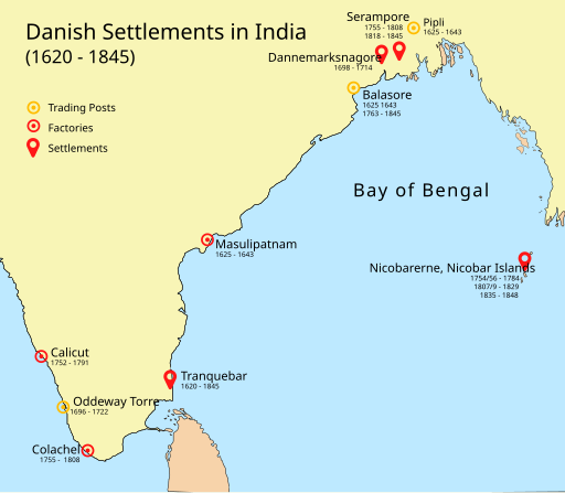
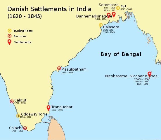
English: Map of Danish settlements and trading posts in India from 1620 - 1845 |
| Dagsetning | |
| Uppruni | Created using illustrator |
| Höfundarréttarhafi | Adondai |
| This file is made available under the Creative Commons CC0 1.0 Universal Public Domain Dedication. | |
| The person who associated a work with this deed has dedicated the work to the public domain by waiving all of their rights to the work worldwide under copyright law, including all related and neighboring rights, to the extent allowed by law. You can copy, modify, distribute and perform the work, even for commercial purposes, all without asking permission.
|
Leyfisupplýsingar:
| I, the copyright holder of this work, release this work into the public domain. This applies worldwide. In some countries this may not be legally possible; if so: I grant anyone the right to use this work for any purpose, without any conditions, unless such conditions are required by law. |
Breytingaskrá skjals
Smelltu á dagsetningu eða tímasetningu til að sjá hvernig hún leit þá út.
| Dagsetning/Tími | Smámynd | Víddir | Notandi | Athugasemd | |
|---|---|---|---|---|---|
| núverandi | 7. maí 2018 kl. 09:07 | | 512 × 446 (162 KB) | Adondai | {{subst:Upload marker added by en.wp UW}} {{Information |Description = {{en|Map of Danish settlements and trading posts in India from 1620 - 1845}} |Source = Created using illustrator |Date = 2018-05-07 |Author = Adondai }} {{cc-zero}} |
Skráartenglar
Eftirfarandi síða notar þessa skrá:
Altæk notkun skráar
Eftirfarandi wikar nota einnig þessa skrá:
- Notkun á ar.wikipedia.org
- Notkun á bn.wikipedia.org
- Notkun á de.wikipedia.org
- Notkun á en.wikipedia.org
- Notkun á en.wikivoyage.org
- Notkun á es.wikipedia.org
- Notkun á fr.wikipedia.org
- Notkun á he.wikipedia.org
- Notkun á id.wikipedia.org
- Notkun á it.wikipedia.org
- Notkun á ja.wikipedia.org
- Notkun á mt.wikipedia.org
- Notkun á nl.wikipedia.org
- Notkun á vi.wikipedia.org
- Notkun á www.wikidata.org
- Notkun á wuu.wikipedia.org
- Notkun á zh.wikipedia.org
.svg)