Mynd:England-878ad.jpg

Stærð þessarar forskoðunar: 471 × 599 mynddílar Aðrar upplausnir: 189 × 240 mynddílar | 377 × 480 mynddílar | 735 × 935 mynddílar.
Upphafleg skrá (735 × 935 mynddílar, skráarstærð: 127 KB, MIME-gerð: image/jpeg)

|
This map has been uploaded by Electionworld from en.wikipedia.org to enable the |
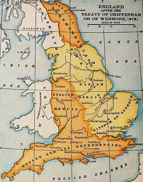
England and Wales at the time of the Treaty of Chippenham (AD 878). From the Atlas of European History, Earle W Dowe (d. 1946), G Bell and Sons, London, 1910
[]
-
 Cymraeg
 -
 Deutsch
 -
 English
 -
 English
 -
 English
 -
 español
 -
 français
 -
 Nederlands
 -
 polski
 -
 magyar


.svg)


|
The author died in 1946, so this work is in the public domain in its country of origin and other countries and areas where the copyright term is the author's life plus 75 years or fewer. This work is in the public domain in the United States because it was published (or registered with the U.S. Copyright Office) before January 1, 1929. | |
| This file has been identified as being free of known restrictions under copyright law, including all related and neighboring rights. | |
Breytingaskrá skjals
Smelltu á dagsetningu eða tímasetningu til að sjá hvernig hún leit þá út.
| Dagsetning/Tími | Smámynd | Víddir | Notandi | Athugasemd | |
|---|---|---|---|---|---|
| núverandi | 7. nóvember 2011 kl. 19:27 | | 735 × 935 (127 KB) | Hel-hama | same source, better version of the image |
| 29. desember 2006 kl. 15:49 |  | 693 × 879 (79 KB) | Electionworld | {{ew|en|Adamsan}} England and Wales at the time of the Treaty of Chippenham (AD 878). From the Atlas of European History, Earle W Dowe, G Bell and Sons, London, 1910 {{PD-US}} |
Skráartenglar
Eftirfarandi 2 síður nota þessa skrá:
Altæk notkun skráar
Eftirfarandi wikar nota einnig þessa skrá:
- Notkun á ar.wikipedia.org
- Notkun á br.wikipedia.org
- Notkun á cs.wikipedia.org
- Notkun á en.wikipedia.org
- Talk:Sub-Roman Britain
- Portal:Denmark/Selected article/2006 archive
- Portal:Denmark/Selected article/Week 20, 2006
- Portal:Denmark/Selected article/2007 archive
- Portal:Denmark/Selected article/Week 4, 2007
- Portal:Denmark/Selected article/Week 5, 2007
- Portal:Denmark/Selected article/Week 45, 2007
- Portal:Denmark/Selected article/Week 46, 2007
- Portal:Denmark/Selected article/2008 archive
- Portal:Denmark/Selected article/Week 3, 2008
- User:Amitchell125/danelaw
- Notkun á eo.wikipedia.org
- Notkun á fy.wikipedia.org
- Notkun á hu.wikipedia.org
- Notkun á id.wikipedia.org
- Notkun á it.wikipedia.org
- Notkun á ja.wikipedia.org
- Notkun á pt.wikipedia.org
- Notkun á sh.wikipedia.org
- Notkun á simple.wikipedia.org
- Notkun á sk.wikipedia.org
- Notkun á th.wikipedia.org
- Notkun á uk.wikipedia.org
- Notkun á zh.wikipedia.org