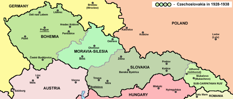
Mynd:Czechoslovakia01.png

Stærð þessarar forskoðunar: 800 × 340 mynddílar Aðrar upplausnir: 320 × 136 mynddílar | 1.100 × 468 mynddílar.
Upphafleg skrá (1.100 × 468 mynddílar, skráarstærð: 63 KB, MIME-gerð: image/png)
Breytingaskrá skjals
Smelltu á dagsetningu eða tímasetningu til að sjá hvernig hún leit þá út.
| Dagsetning/Tími | Smámynd | Víddir | Notandi | Athugasemd | |
|---|---|---|---|---|---|
| núverandi | 12. júlí 2022 kl. 14:48 |  | 1.100 × 468 (63 KB) | Sebastian Wallroth | cropped |
| 19. maí 2011 kl. 10:54 |  | 1.128 × 513 (63 KB) | PANONIAN | minor change, marked provincial capitals | |
| 17. maí 2011 kl. 09:53 |  | 1.128 × 513 (62 KB) | PANONIAN | Reverted to version as of 10:38, 24 April 2011 - because this is map of Czechoslovakia and it was capital of Czechoslovakia | |
| 17. maí 2011 kl. 05:07 |  | 1.128 × 513 (55 KB) | Millenium187 | Why was Prague underlined and Vienna, Brno, Bratislava and other capital cities were not? -- corrected | |
| 24. apríl 2011 kl. 10:38 |  | 1.128 × 513 (62 KB) | PANONIAN | few corrections | |
| 23. apríl 2011 kl. 11:31 |  | 1.128 × 509 (61 KB) | PANONIAN | improved version | |
| 20. desember 2008 kl. 20:58 |  | 1.100 × 497 (78 KB) | Kirk979 | {{Information |Description= |Source= |Date= |Author= |Permission= |other_versions= }} | |
| 28. desember 2006 kl. 16:11 |  | 1.100 × 497 (90 KB) | Electionworld | {{ew|en|PANONIAN}} Map of {{link|Czechoslovakia}} (self made) Note: The provinces shown on the map were introduced by Act No. 125/1927 Zb. and became effective in 1928. {{PD-self}} Category:Maps of Czechoslovakia Category:Maps of Czech history |
Skráartenglar
Eftirfarandi síða notar þessa skrá:
Altæk notkun skráar
Eftirfarandi wikar nota einnig þessa skrá:
- Notkun á af.wikipedia.org
- Notkun á als.wikipedia.org
- Notkun á ang.wikipedia.org
- Notkun á an.wikipedia.org
- Notkun á ar.wikipedia.org
- Notkun á arz.wikipedia.org
- Notkun á azb.wikipedia.org
- Notkun á az.wikipedia.org
- Notkun á ba.wikipedia.org
- Notkun á bcl.wikipedia.org
- Notkun á be-tarask.wikipedia.org
- Notkun á be.wikipedia.org
- Notkun á bg.wikipedia.org
- Notkun á bn.wikipedia.org
- Notkun á br.wikipedia.org
- Notkun á ca.wikipedia.org
- Notkun á cs.wikipedia.org
- Notkun á cv.wikipedia.org
- Notkun á cy.wikipedia.org
- Notkun á de.wikipedia.org
- Notkun á diq.wikipedia.org
- Notkun á dsb.wikipedia.org
- Notkun á el.wikipedia.org
- Notkun á en.wikipedia.org
Skoða frekari altæka notkun þessarar skráar.


